
Ancient Chinese civilization emerged along two great rivers — the Yellow River (Huang He) in the north and the Yangtze (Chang Jiang) in the south — and gradually expanded to encompass one of the most geographically diverse empires in history.
Introduction
China's geography is defined by dramatic contrasts: the fertile North China Plain versus the Gobi Desert, the Tibetan Plateau (averaging 4,500 m elevation) versus the subtropical lowlands, and the Pacific coast versus the Central Asian steppe. These contrasts shaped everything from agricultural practices to military strategy to cultural identity.
From the early Shang Dynasty (c. 1600 BCE) through the unified Qin Empire (221 BCE) and beyond, Chinese rulers grappled with a fundamental geographic challenge: how to connect and defend a vast territory spanning 9.6 million km² of incredibly varied terrain.
The Yellow River (Huang He)
- Length: 5,464 km — China's second-longest river
- Loess Plateau: The river carries 1.6 billion tons of sediment annually, giving it its yellow color
- Floods: Called "China's Sorrow" — catastrophic floods killed millions throughout history
The Yellow River was the cradle of Chinese civilization. The Shang and Zhou dynasties arose on the fertile but flood-prone North China Plain, where loess soil (wind-deposited silt up to 300 m deep) supported millet agriculture. The river's tendency to shift course — it has changed its mouth location by hundreds of kilometers multiple times — caused devastating floods but also created new farmland.
Managing the Yellow River became a defining challenge of Chinese statecraft. The earliest known Chinese engineering projects were flood control works along this river, and a ruler's ability to tame its waters was considered a test of their legitimacy.
The Yangtze River and Southern Expansion
- Length: 6,300 km — Asia's longest river and the world's third longest
- Rice Agriculture: The Yangtze basin became China's rice bowl, with paddy cultivation dating to 7000 BCE
- Three Gorges: A 200 km stretch of dramatic gorges cutting through limestone mountains
While the Yellow River cradle birthed Chinese civilization, the Yangtze basin ultimately became its economic engine. Rice cultivation in the warm, wet Yangtze lowlands produced far more calories per hectare than northern wheat and millet, supporting denser populations. By the Song Dynasty (960–1279 CE), southern China produced the majority of the empire's wealth.
The geographic barrier of the Qinling Mountains and Huai River traditionally divided northern and southern China — a cultural and agricultural boundary that persists today. North of this line, wheat and millet dominate; south of it, rice paddies cover the landscape.
The Great Wall and Northern Frontiers
- Total Length: Over 21,000 km including all branches and dynasties
- Purpose: Defensive barrier against steppe nomads — also controlled trade and migration
- Geography: Follows the ecological boundary between farmland and steppe grassland at roughly 400 mm annual rainfall
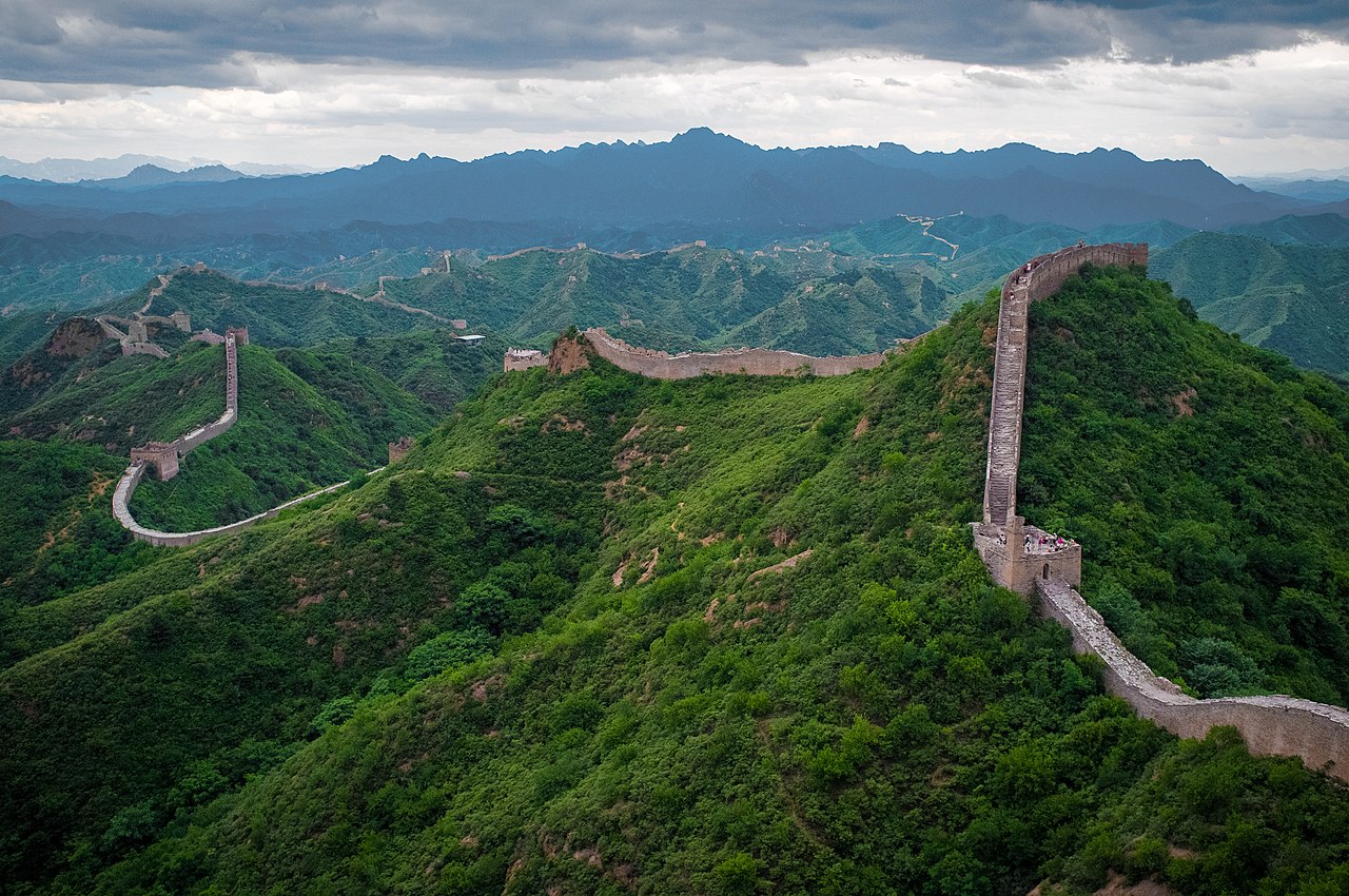
The Great Wall is fundamentally a geographic feature — it traces the ecological boundary between the settled agricultural zone and the nomadic steppe. Where annual rainfall drops below 400 mm, farming becomes unreliable and pastoralism dominates. The Wall marks this transition almost precisely.
Qin Shi Huang connected existing walls into a unified barrier around 221 BCE, but most visible remains date from the Ming Dynasty (1368–1644). The Wall served not just as a military fortification but as a customs boundary, immigration checkpoint, and communication network via its beacon tower system.
The Silk Road and Western Connections
- Route Length: Over 6,400 km from Chang'an (Xi'an) to the Mediterranean
- Key Geography: Crossed the Gansu Corridor, Taklamakan Desert, Pamir Mountains, and Central Asian steppes
- Peak Period: Han Dynasty (206 BCE–220 CE) through Tang Dynasty (618–907 CE)
The Silk Road was shaped by Central Asia's harsh geography. The Gansu Corridor — a narrow strip between the Tibetan Plateau and the Gobi Desert — funneled traffic through a passable route. Beyond lay the Taklamakan Desert, one of the world's most inhospitable regions, which traders skirted along its northern or southern rim via oasis towns like Dunhuang, Turfan, and Kashgar.
This trade network connected China to Persia, Rome, and India, transmitting not just silk but also paper, gunpowder, Buddhism, Islam, and the Black Death. The geography of Central Asia — its mountain passes, desert oases, and steppe corridors — determined which civilizations could interact and how.
Key Facts
- The Yellow River carries 1.6 billion tons of sediment annually — more than any other river
- The Great Wall stretches over 21,000 km including all historical sections
- The Silk Road connected Chang'an to Rome — over 6,400 km
- Rice cultivation along the Yangtze dates back to at least 7000 BCE
- China's geography spans from sea level to 8,849 m (Everest) — the greatest elevation range of any country
Fun Facts
- The Yellow River has changed its course to the sea at least 26 times in recorded history, with its mouth shifting by up to 800 km
- The Great Wall is not visible from space with the naked eye — this is a persistent myth
- The Terracotta Army of Xi'an (Qin Dynasty) was buried just 35 km from the eastern terminus of the Silk Road
- China's Grand Canal (1,776 km) is the world's longest artificial waterway, connecting the Yellow and Yangtze rivers since the 5th century BCE
Final Thoughts
Ancient China's geography — vast river systems, mountain barriers, desert frontiers, and maritime coastlines — created a civilization that was both deeply connected internally and strategically isolated from external threats. The interplay between these geographic forces shaped 4,000 years of dynastic history and continues to influence China today.
Test Your Knowledge!
Think you know your ancient civilizations? Try our interactive geography quiz!
Play Geography Games →