
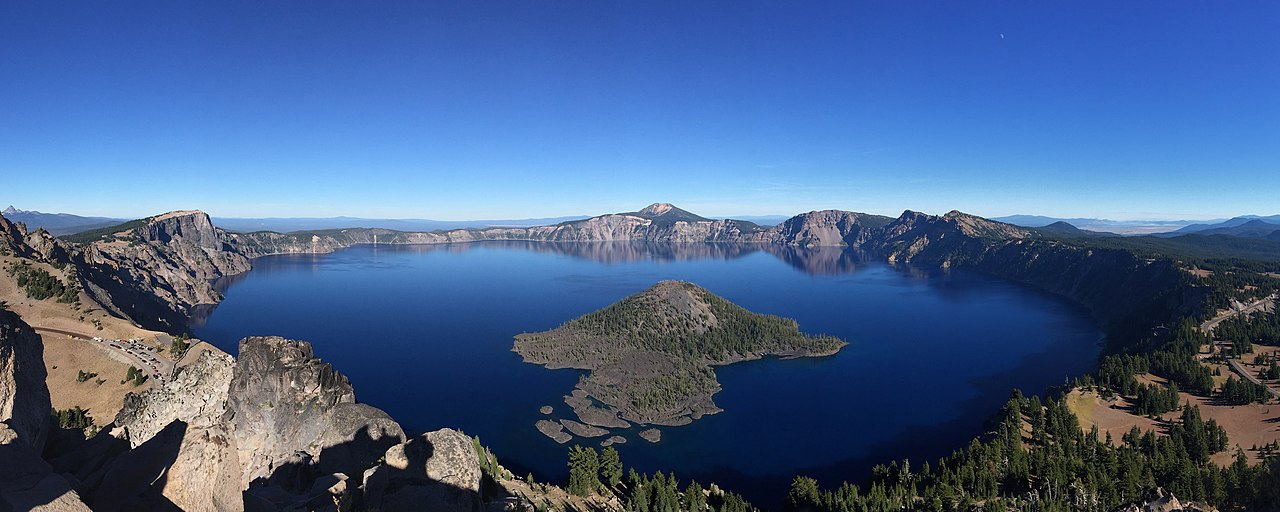
Crater Lake National Park, established on May 22, 1902, protects 183,224 acres of volcanic landscape in the Cascade Range of southern Oregon, centered on the deepest lake in the United States. Crater Lake fills the caldera of ancient Mount Mazama, which collapsed during a catastrophic eruption approximately 7,700 years ago. At 1,943 feet (592 meters), it is the deepest lake in the US and the ninth deepest in the world.
Introduction
The lake's remarkable deep blue color — among the most vivid of any body of water on Earth — results from its extraordinary clarity and depth. With no inlet streams and no outlet, the lake is fed entirely by rain and snowfall (averaging 43 feet of snow annually), producing water of exceptional purity. Approximately 704,000 visitors come annually to gaze from the rim, hike the surrounding wilderness, and, if they dare, swim in the 60°F waters of this volcanic jewel.

The Lake
- Depth: 1,943 feet (deepest in the US, 9th deepest globally)
- Diameter: Approximately 5 miles across
- Surface Elevation: 6,178 feet
- Water Clarity: Secchi disk visible to 100+ feet depth
- Wizard Island: Volcanic cinder cone rising 755 feet above the lake
Crater Lake's mesmerizing blue is the result of its extreme depth and clarity. Sunlight penetrates deep into the water, where red wavelengths are absorbed and blue wavelengths are scattered back to the surface. Because the lake is fed only by precipitation — no sediment-carrying streams flow into it — the water is exceptionally pure. Secchi disk measurements have recorded visibility exceeding 100 feet, making it one of the clearest lakes in the world.
Wizard Island, a volcanic cinder cone that rises 755 feet above the lake surface on its western side, formed shortly after the caldera collapsed and the lake began to fill. A second volcanic feature, Phantom Ship, is a small rocky island on the lake's southern edge that resembles a ghost ship in fog. The lake takes approximately 250 years to completely replace its water through evaporation and seepage, maintaining a remarkably constant level despite having no outlet.
Volcanic Origins
- Mount Mazama Eruption: Approximately 7,700 years ago
- Eruption Volume: 42 times more than Mount St. Helens (1980)
- Ash Distribution: Found as far as British Columbia and Nevada
- Caldera Dimensions: 5 miles wide, nearly 4,000 feet from rim to lake bottom
Mount Mazama was once a composite stratovolcano reaching an estimated 12,000 feet — comparable to other Cascade peaks like Mount Hood and Mount Rainier. Approximately 7,700 years ago, a cataclysmic eruption emptied the magma chamber so rapidly that the mountaintop collapsed inward, creating the caldera that now holds the lake. The eruption ejected approximately 12 cubic miles of material — 42 times more than the 1980 eruption of Mount St. Helens.
The eruption was witnessed by the ancestors of the Klamath Tribe, who passed down oral traditions describing the mountain's destruction for over 7,000 years — one of the longest-documented oral histories of a geological event. Archaeological evidence shows that pumice from the eruption fell several inches thick across an area the size of New England. The Pinnacles, towering spires of volcanic ash cemented by hot gases called fumaroles, are visible along the park's eastern road.
Trails & Rim Drive
- Rim Drive: 33-mile scenic loop around the caldera
- Total Trail Miles: Over 90 miles
- Cleetwood Cove Trail: The only trail to the lake shore (2.2 miles round trip)
- Mount Scott: Highest point in the park at 8,929 feet
Rim Drive, a 33-mile loop, circles the caldera rim with over 30 viewpoints offering different perspectives of the lake, Wizard Island, and the surrounding Cascade landscape. The road climbs to 7,863 feet at its highest point and is typically open from July through October, as the park receives an average of 43 feet of snow per year — among the snowiest places in the Cascades.
The Cleetwood Cove Trail is the only legal access to the lake shore, descending 700 feet in 1.1 miles to a dock where ranger-guided boat tours depart for Wizard Island. The trail is steep and strenuous on the return climb. The Mount Scott Trail (5 miles round trip) leads to the park's highest point at 8,929 feet, offering panoramic views of the lake, the Cascade Range, and on clear days, Mount Shasta 125 miles to the south. The Garfield Peak Trail (3.4 miles round trip) provides what many consider the best overlook of the lake.
Seasons & Visiting
- Annual Snowfall: Average 43 feet (516 inches)
- Best Time to Visit: July through September
- Winter Access: South and west entrance roads open year-round
- Annual Visitors: Approximately 704,000
Crater Lake's extreme snowfall — averaging 43 feet annually with a record of 73 feet in 1932-33 — dominates the park experience for much of the year. Snow typically covers the rim from October through June, and Rim Drive does not fully open until July in most years. The heavy snowfall, however, creates outstanding cross-country skiing and snowshoe opportunities, with ranger-led snowshoe walks offered on weekends in winter.
Summer (July-September) is the prime visiting season, when all roads, trails, and facilities are accessible. Even in summer, nighttime temperatures can drop near freezing at the rim, and afternoon thunderstorms are common. The boat tour to Wizard Island is the park's premier activity, offering a unique perspective from the lake surface and the opportunity to hike the island's cinder cone. Swimming is permitted but the water temperature rarely exceeds 60°F even in August.
Key Facts
- Crater Lake is 1,943 feet deep — the deepest lake in the United States and the ninth deepest in the world.
- The lake formed in the caldera of Mount Mazama after a catastrophic eruption 7,700 years ago.
- The eruption ejected 42 times more material than the 1980 Mount St. Helens eruption.
- The lake has no inlet or outlet streams — it is fed entirely by rain and snow.
- The park receives an average of 43 feet of snow per year, keeping Rim Drive closed until July.
Fun Facts
- The Klamath Tribe's oral tradition describing Mount Mazama's destruction has been passed down for over 7,700 years — one of the oldest verifiable oral histories in the world.
- A hemlock log nicknamed "The Old Man of the Lake" has been floating vertically in the lake since at least 1896 and has been tracked by researchers for over a century.
- Crater Lake's water is so pure that it was once considered for use as a US drinking water standard.
- Despite its depth and cold temperatures, the lake has never frozen over completely in recorded history due to the volume of water that must lose heat.
Final Thoughts
Crater Lake National Park centers on a single feature of such extraordinary beauty that it needs no accompaniment. The lake's impossible blue — deeper and more vivid than any photograph can capture — is the legacy of one of the most violent geological events in the recent history of North America. Standing on the rim, gazing at water that fell as rain and snow with nothing else added, visitors witness purity in its most literal and stunning form.
Test Your Knowledge!
Think you know America's national parks? Try our interactive geography quiz!
Play Geography Games →