

Introduction
Hadrian's Wall is a Roman fortification stretching 117 kilometers across the narrow neck of northern England, from Wallsend on the River Tyne in the east to Bowness-on-Solway on the Irish Sea in the west. Built beginning in AD 122 on the orders of Emperor Hadrian, it marked the northwestern frontier of the Roman Empire and served as a border defense, customs checkpoint, and symbol of imperial power for nearly three centuries.
The wall remains the most impressive and best-preserved frontier of the Roman Empire anywhere in the world. Large sections still stand to significant height, and the associated forts, milecastles, and turrets reveal a sophisticated system of border management that has parallels with modern international boundaries. It was designated a UNESCO World Heritage Site in 1987 as part of the "Frontiers of the Roman Empire."
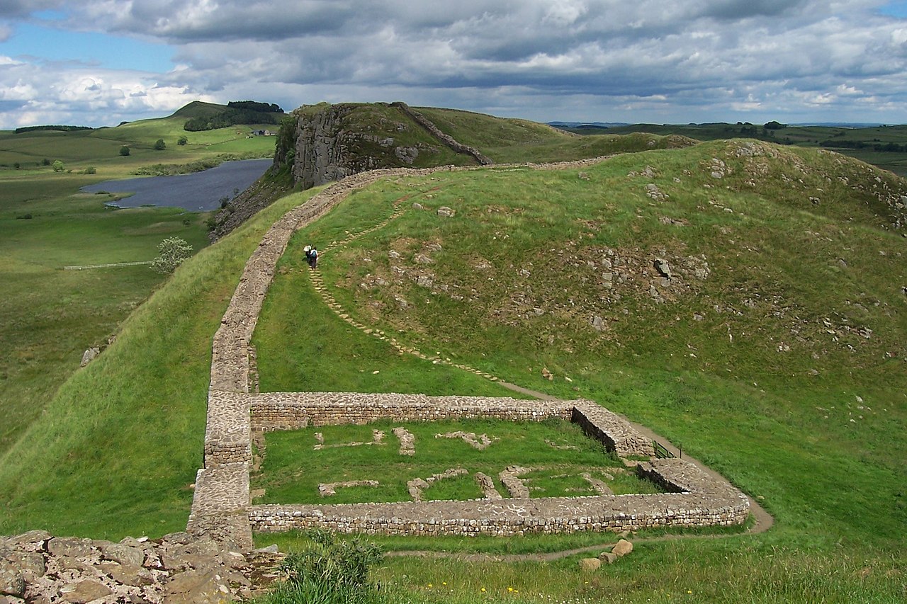
Geography & Route
- Total Length: 117 km (73 Roman miles, 80 modern miles)
- Width: Up to 3 meters (stone section), 6 meters (turf section)
- Height: Up to 4.5 meters including parapet
- Route: Coast to coast across northern England's narrowest point
Hadrian's Wall follows the geological formation of the Whin Sill, a dramatic ridge of volcanic dolerite that runs east-west across northern England. The wall's builders took advantage of this natural high ground, creating a boundary that combined engineered fortifications with imposing natural cliffs. In the central section near Housesteads, the wall perches atop sheer cliff faces that make it appear even more formidable.
The eastern section from Wallsend to the River Irthing was built in stone, while the western section from the Irthing to Bowness-on-Solway was originally constructed of turf and timber before being rebuilt in stone. The wall crossed rivers, ascended and descended steep valleys, and traversed open moorland, demonstrating remarkable Roman engineering adapted to challenging terrain.
History & Formation
- Construction Began: AD 122 under Emperor Hadrian
- Construction Time: Approximately 6 years for the main wall
- Active Use: AD 122 to approximately AD 410
- Builders: Legionary soldiers, approximately 15,000 men
Emperor Hadrian visited Britain in AD 122 and ordered the construction of a continuous wall to mark and defend the empire's northern frontier. The wall was built primarily by soldiers from three Roman legions — the II Augusta, VI Victrix, and XX Valeria Victrix — who left inscriptions recording their work on many stones along the wall. Each legion was responsible for specific sections, and their construction styles are sometimes distinguishable.
The wall was not intended as a fighting platform but rather as a means of controlling movement across the frontier. People and goods could pass through the wall only at designated crossing points (milecastles), where customs duties were collected and identities checked. This system of regulated permeability is remarkably similar to modern border management practices, suggesting that Roman border policy was more about control than exclusion.
Key Features
- Forts: 16 major forts along or near the wall
- Milecastles: 80 small fortified gateways at one-mile intervals
- Turrets: 160 observation towers between milecastles
- Vallum: Large earthwork ditch running south of the wall
The wall was part of a complex defensive system that included much more than the wall itself. Sixteen major forts, each housing between 500 and 1,000 auxiliary soldiers, were built along the wall at intervals of about 7 miles. Between each pair of forts, a milecastle provided a fortified gateway through the wall, and between each pair of milecastles, two turrets served as observation posts.
South of the wall, the Romans dug the Vallum, a massive flat-bottomed ditch flanked by earth mounds that created a military exclusion zone behind the wall. North of the wall, another ditch was excavated to slow approaching enemies. The entire system — wall, ditch, vallum, forts, milecastles, and turrets — represented a comprehensive approach to frontier management that was unmatched in the ancient world.
Political Significance
- Roman Frontier: Northwestern boundary of the Roman Empire
- Hadrian's Policy: Reflected shift from expansion to consolidation
- Cultural Boundary: Divided "civilized" Rome from "barbarian" north
- UNESCO Status: World Heritage Site since 1987
Hadrian's Wall represented a fundamental shift in Roman imperial policy. While previous emperors had sought to expand the empire's borders through conquest, Hadrian pursued a policy of consolidation and defense. The wall physically embodied this philosophy, marking the point where Rome chose to stop expanding and instead invest in defending what it had already gained.
The wall served as a cultural as well as military boundary, separating the Romanized population of the province of Britannia from the unconquered Caledonian tribes to the north. Archaeological evidence reveals a vibrant multicultural community along the wall, with soldiers recruited from across the empire — North Africa, Syria, Spain, and the Low Countries — all serving on this remote frontier.
Modern Day
- Hadrian's Wall Path: 135 km National Trail following the wall's route
- Major Sites: Housesteads, Vindolanda, Chesters, Birdoswald
- Vindolanda Tablets: Remarkable wooden writing tablets discovered at the fort
- Tourism: Over 1 million visitors annually
Hadrian's Wall Path, a 135-kilometer National Trail, follows the wall's route from coast to coast and is one of England's most popular long-distance walks. The trail passes through dramatic landscapes including the crags of the Whin Sill, pastoral farmland, and the remnants of Roman forts. Key archaeological sites along the route include Housesteads, the best-preserved Roman fort in Britain, and Vindolanda, where extraordinary wooden writing tablets have provided intimate details of life on the frontier.
The Vindolanda tablets, discovered from the 1970s onward, are among the most important archaeological finds in Britain. These thin wooden postcards, preserved in waterlogged conditions, reveal the daily lives of soldiers and their families on the wall — requests for supplies, birthday party invitations, complaints about the weather, and reports on the fighting qualities of the local tribes. They humanize the wall in a way that stone ruins alone cannot.
Key Facts
- Hadrian's Wall is 117 km long, stretching coast to coast across northern England
- Built beginning in AD 122 by approximately 15,000 Roman legionary soldiers
- The wall system includes 16 forts, 80 milecastles, and 160 turrets
- It served as the Roman Empire's northwestern frontier for nearly 300 years
- Designated a UNESCO World Heritage Site in 1987 as part of the Frontiers of the Roman Empire
Fun Facts
- Soldiers from as far as North Africa and Syria were stationed at this cold, rainy northern frontier
- The Vindolanda tablets include what may be the earliest known writing by a woman in Latin, a birthday party invitation from Claudia Severa
- Much of the wall's stone was robbed over the centuries to build local farmhouses, churches, and roads
- The wall was so well-known as a boundary that medieval maps sometimes showed it as the border between England and Scotland, though it lies entirely within England
Final Thoughts
Hadrian's Wall is far more than a ruined fortification — it is a window into how the ancient world's greatest empire managed its borders. The sophisticated system of walls, forts, and controlled crossing points reveals that the challenges of border management are as old as civilization itself. Nearly two thousand years after its construction, Hadrian's Wall continues to fascinate visitors and scholars as one of the most remarkable frontiers ever built.
