
Hong Kong is a Special Administrative Region of China occupying 1,114 km² of mountainous terrain on the South China Sea coast at the Pearl River Delta estuary. Despite its reputation as a dense urban jungle, roughly 75% of Hong Kong's land area is undeveloped countryside—steep, forested mountains and rugged coastline—because only a fraction of the territory is flat enough to build on.
Introduction
The territory comprises Hong Kong Island, the Kowloon Peninsula, the New Territories (mainland), and 263 outlying islands. Victoria Harbour, the deep, sheltered strait between Hong Kong Island and Kowloon, was the geographic feature that attracted British colonization in 1841 and remains the symbolic heart of the city. With 7.5 million people crammed into the small percentage of flat and reclaimed land, Hong Kong is one of the most densely populated places on Earth.
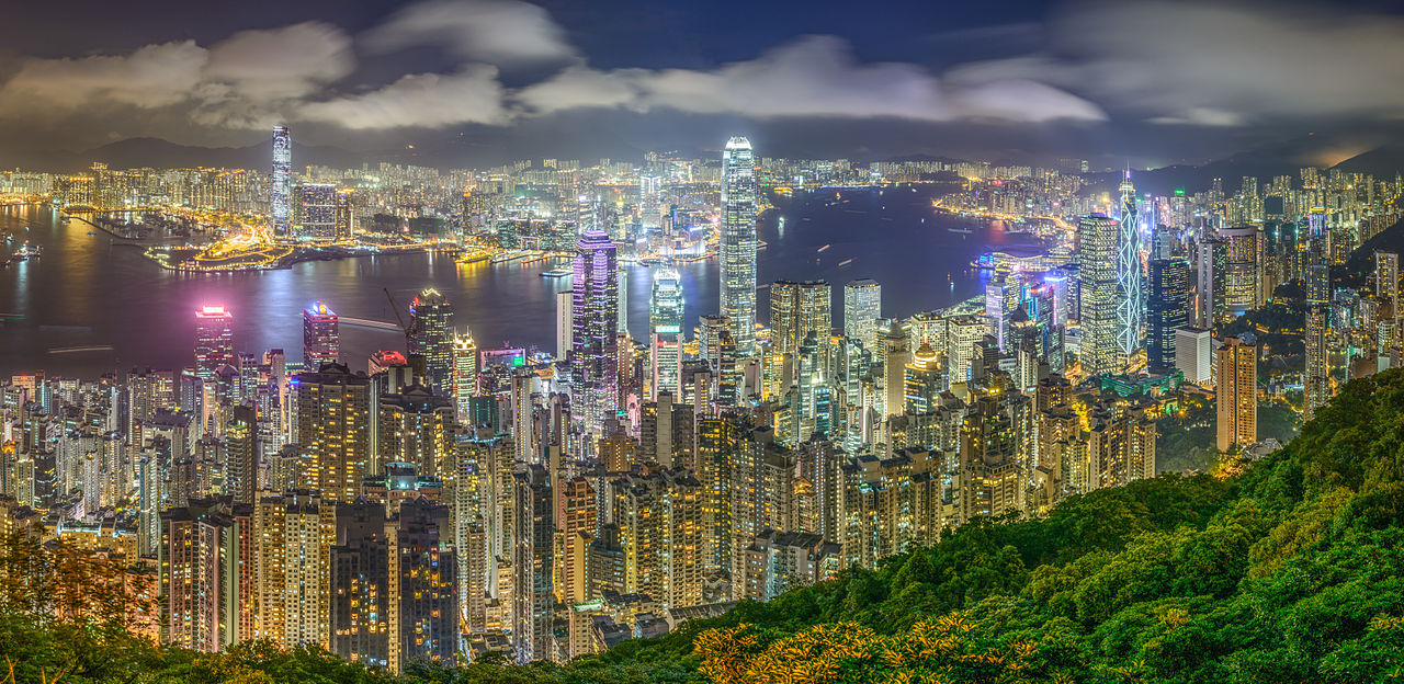
Location & Setting
- Coordinates: 22.3193°N, 114.1694°E
- Elevation Range: 0–957 m (Tai Mo Shan)
- Area: 1,114 km² (including 263 islands)
- Region: South China Sea coast, Pearl River Delta estuary
Hong Kong sits on the southeastern coast of China at the mouth of the Pearl River, roughly 60 km east of Macau and 130 km south of Guangzhou. The territory is divided into Hong Kong Island (81 km²), Kowloon (47 km²), the New Territories (747 km²), and outlying islands (175 km²). Lantau Island (147 km²) is the largest island, bigger than Hong Kong Island itself.
Victoria Harbour, the strait between Hong Kong Island and Kowloon, is one of the deepest natural harbors in the world, with depths reaching 12–15 m. This deep, sheltered anchorage—protected from typhoons by the surrounding mountains—was the reason the British seized Hong Kong in 1841. The harbor has been progressively narrowed by land reclamation on both sides, reducing its width from about 1.6 km to less than 1 km in places.
Terrain & Landscape
- Mountains: Steep terrain, ~75% of territory undeveloped
- Tai Mo Shan: 957 m, highest peak in Hong Kong
- Victoria Peak: 552 m, iconic overlooking the harbor
- Flat Land: Only ~25% of territory is developable
Hong Kong's terrain is overwhelmingly mountainous and steep. Tai Mo Shan (957 m), in the New Territories, is the highest peak, but numerous other summits exceed 500 m. Victoria Peak (552 m) on Hong Kong Island provides the famous panoramic view of the harbor and skyline. The steep terrain means that much of Hong Kong's development is concentrated on narrow coastal strips and reclaimed land—roughly 70 km² of the territory (about 6%) is reclaimed from the sea.
The undeveloped 75% of Hong Kong's area is covered by subtropical forests, grasslands, and scrubland, protected in a system of 24 country parks and 22 special areas covering roughly 40% of the territory. This means Hong Kong has some of the most accessible urban wilderness of any major city—forested mountains with hiking trails are often just minutes from dense urban areas.
Climate & Weather
- Climate Type: Humid subtropical (Köppen Cwa)
- Average Summer Temp: 27–32°C with extreme humidity
- Average Winter Temp: 12–19°C
- Annual Rainfall: ~2,400 mm, mostly May–September
Hong Kong has a humid subtropical climate with hot, humid summers and mild, drier winters. Summer (June–September) combines temperatures of 30–33°C with humidity above 80%, creating stifling conditions. The summer monsoon brings heavy rainfall, with 80% of the annual 2,400 mm falling between May and September. Individual rainstorms can drop 100+ mm in hours, causing landslides on the steep terrain.
Typhoon season (May–November) poses the most dramatic weather risk. Hong Kong lies directly in the path of western Pacific typhoons, and the government operates a numbered warning system (T1 to T10) that can shut down the entire city when a major typhoon approaches. Super Typhoon Mangkhut in 2018 brought sustained winds over 180 km/h and caused widespread tree damage, power outages, and coastal flooding.
Land Reclamation & Density
- Reclaimed Land: ~70 km² (6% of territory)
- Population Density: Kowloon: 44,000+/km² in some areas
- Building Height: World's most vertical skyline, 1,500+ buildings over 100 m
- MTR System: Underground rail handles 5+ million trips daily
The extreme scarcity of flat land has driven Hong Kong to reclaim land from the sea since the 19th century. The airport (Chek Lap Kok), much of the Kowloon waterfront, and large portions of Hong Kong Island's north shore are built on reclaimed land. The practice has narrowed Victoria Harbour significantly and is now restricted to protect the harbor. New developments increasingly focus on the New Territories and outlying islands.
Land scarcity has also driven vertical construction to an extreme. Hong Kong has more skyscrapers (buildings over 150 m) than any other city in the world—over 500. Residential buildings commonly reach 40–60 stories. Kowloon's Mong Kok district has a population density exceeding 100,000 people per km² in some blocks, among the highest in the world. This density is made functional by the efficient MTR subway system, which handles over 5 million trips daily.
Natural Hazards
- Typhoons: Direct hits every few years; T10 signal shuts down the city
- Landslides: Major risk on steep terrain during heavy rain
- Flooding: Low-lying reclaimed areas vulnerable to storm surge
- Sea Level Rise: Threatens low-lying waterfront and reclaimed land
Landslides are Hong Kong's most persistent natural hazard. The steep terrain, heavy rainfall, and extensive cut slopes for development create constant landslide risk. The Geotechnical Engineering Office maintains a database of over 120,000 man-made slopes that require monitoring and maintenance. A catastrophic 1972 landslide at Po Shan Road killed 67 people and led to the creation of the comprehensive slope safety program.
Typhoon storm surge is a growing concern as sea levels rise. Much of Hong Kong's critical infrastructure—the airport, port facilities, waterfront developments, and MTR stations—sits on low-lying reclaimed land vulnerable to surge. The 2018 Super Typhoon Mangkhut produced a 3.5 m storm surge that flooded coastal areas and caused billions of dollars in damage. Climate projections suggest more intense typhoons in the coming decades.
Key Facts
- About 75% of Hong Kong's territory is undeveloped mountainous countryside, despite extreme urban density.
- Roughly 70 km² (6% of the territory) is reclaimed land, including the airport and much of the waterfront.
- Hong Kong has over 500 skyscrapers—more than any other city in the world.
- Annual rainfall of ~2,400 mm, mostly in the May–September monsoon, drives significant landslide risk.
- Victoria Harbour's deep, sheltered waters (12–15 m) attracted British colonization in 1841.
Fun Facts
- Hong Kong has 24 country parks covering 40% of the territory, with forested mountains minutes from urban areas.
- The Geotechnical Engineering Office monitors over 120,000 man-made slopes for landslide risk.
- Hong Kong Island's famous skyline is largely built on reclaimed land that didn't exist 150 years ago.
- Super Typhoon Mangkhut (2018) produced a 3.5 m storm surge and sustained winds over 180 km/h.
Final Thoughts
Hong Kong's geography is a study in extreme contrasts: mountainous wilderness and hyper-dense urbanization, deep harbor waters and land reclaimed from the sea, subtropical forests and the world's tallest skyline. The same mountainous terrain that limits flat land has forced vertical construction and preserved vast swathes of countryside, making Hong Kong simultaneously one of the densest and most nature-accessible cities on Earth. Typhoons, landslides, and sea level rise are the geographic forces that continue to shape this remarkable territory.
Test Your Knowledge!
Think you know world city geography? Test your knowledge with our interactive games!
Play Geography Games →