
The Lake Eyre Basin is the largest internally draining river system in Australia, covering approximately 1.14 million square kilometers — roughly one-sixth of the Australian continent. At its heart lies Kati Thanda-Lake Eyre, a vast salt lake that sits 15 meters below sea level, the lowest point in Australia. In most years, the lake is a dry, white salt crust, but when exceptional rains fall across the basin, it fills to become Australia's largest lake.
Introduction
Lake Eyre fills on average only about four times per century, and each filling event triggers one of the most remarkable ecological transformations on Earth. Within weeks of water arriving, the barren salt lake erupts with life — fish, waterbirds, and invertebrates materialize as if from nowhere, drawn by instincts honed over millennia to exploit these rare, temporary wetlands in the heart of the Australian desert.
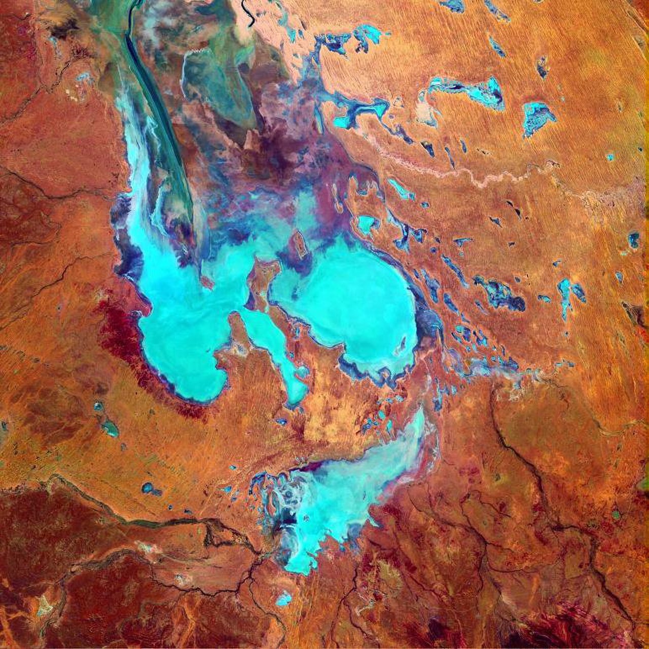
Geographic Setting
- Location: Central Australia, South Australia and Queensland
- Basin Area: 1.14 million km²
- Lake Area (full): ~9,500 km² when completely filled
- Elevation: -15 m (lowest point in Australia)
The Lake Eyre Basin spans the arid heart of Australia, from the Channel Country of western Queensland to the deserts of central South Australia. The basin's rivers — including Cooper Creek, the Diamantina, the Georgina, and Warburton — meander across vast, flat floodplains for thousands of kilometers before reaching Lake Eyre (if they reach it at all; most flows dissipate in the desert before arriving).
When fully flooded, Lake Eyre covers roughly 9,500 square kilometers and can hold 30 cubic kilometers of water. However, full fillings are rare events — the last major filling was in 1974, and significant partial fillings occur roughly every decade. The lake is divided into two basins: Lake Eyre North and the smaller Lake Eyre South, connected by the Goyder Channel.
Ecology & Wildlife
- Key Species: Banded stilt, pelicans, Lake Eyre hardyhead (endemic fish)
- Waterbird Response: Hundreds of thousands converge within weeks of flooding
- Fish: Native species survive in permanent waterholes
- Vegetation: Samphire, lignum, coolibah woodland
The most spectacular ecological response to Lake Eyre flooding is the arrival of hundreds of thousands of waterbirds, including Australian pelicans, banded stilts, silver gulls, and various wading birds. Australian pelicans can detect flooding events from thousands of kilometers away and converge on the lake to breed in enormous colonies. Banded stilts, small shorebirds that normally inhabit coastal salt lakes, fly inland in their tens of thousands to breed on the lake's temporary islands.
Fish survive the dry periods in permanent waterholes (called "refugia") along the basin's rivers. When floods connect these waterholes, fish populations explode, rapidly colonizing hundreds of kilometers of newly flooded channels. The Lake Eyre hardyhead, a small endemic fish, is found only in the basin and is adapted to the extreme salinity and temperature fluctuations of this ephemeral system.
Hydrology & Climate
- Water Source: Monsoon rainfall in far-off Queensland highlands
- Travel Time: Floodwater takes months to reach Lake Eyre from Queensland
- Average Rainfall (at lake): ~125 mm/year
- Evaporation Rate: Over 2,500 mm/year
Lake Eyre's water comes almost entirely from rainfall thousands of kilometers to the north, where monsoon storms drench the catchment headwaters in Queensland. Floodwater then travels southward through the Channel Country, a vast braided river network where water spreads across floodplains up to 60 kilometers wide. The journey can take months, and most water evaporates or is absorbed before reaching the lake.
The Lake Eyre Basin receives an average of only 125 millimeters of rainfall annually at the lake itself, while evaporation exceeds 2,500 millimeters per year. This extreme deficit means the lake can only fill from distant river inflows. The pattern of filling is highly irregular — driven by the El Niño-Southern Oscillation (ENSO) and the Indian Ocean Dipole — making the lake one of the most variable water bodies on Earth.
Conservation & Threats
- Protected Status: Lake Eyre National Park; rivers largely unregulated
- Main Threats: Mining, pastoral grazing, water extraction proposals, climate change
- Conservation Value: One of the last unregulated river systems on Earth
- Cultural Significance: Arabana people's traditional country
The rivers of the Lake Eyre Basin are among the last large unregulated river systems in the world — free of dams and major water diversions. This unregulated status is critical to their ecological function, as the natural boom-and-bust cycle of flooding cannot be replicated with managed water releases. Conservation groups have fought proposals for cotton irrigation, mining water extraction, and dam construction that could disrupt this natural hydrology.
The Lake Eyre Basin is the traditional country of the Arabana people, who know the lake as Kati Thanda. Their cultural connection to the landscape stretches back tens of thousands of years, and their knowledge of the basin's ephemeral water sources, seasonal patterns, and wildlife behavior represents an irreplaceable understanding of one of the world's most extreme environments.
Key Facts
- The Lake Eyre Basin covers 1.14 million km² — one-sixth of Australia.
- Lake Eyre sits 15 meters below sea level, the lowest point in Australia.
- The lake fills on average only about four times per century.
- Hundreds of thousands of waterbirds converge within weeks of a major flooding event.
- The basin's rivers are among the last large unregulated river systems in the world.
Fun Facts
- Australian pelicans can somehow detect a Lake Eyre filling event from over 1,000 kilometers away and fly inland to breed on the temporary lake.
- When fully flooded, Lake Eyre is visible from space as a huge blue eye in the red Australian desert.
- Floodwater from Queensland can take six months or more to travel the full distance to Lake Eyre.
Final Thoughts
The Lake Eyre Basin is one of Earth's most remarkable hydrological systems — a million-square-kilometer catchment that channels rare monsoon floods into the heart of a desert, creating temporary wetlands of staggering ecological productivity. Its unregulated rivers are a priceless natural heritage in a world where most major river systems have been dammed and diverted.
Test Your Knowledge!
Think you know the world's great wetlands and deltas? Try our geography quiz games!
Play Geography Games →