
Iowa is far from the featureless plain many imagine. The state's landscape records multiple glacial advances, each leaving distinct terrain, and two of its most remarkable landforms — the Loess Hills and the Driftless Area — are found in only a handful of places on Earth.
Introduction
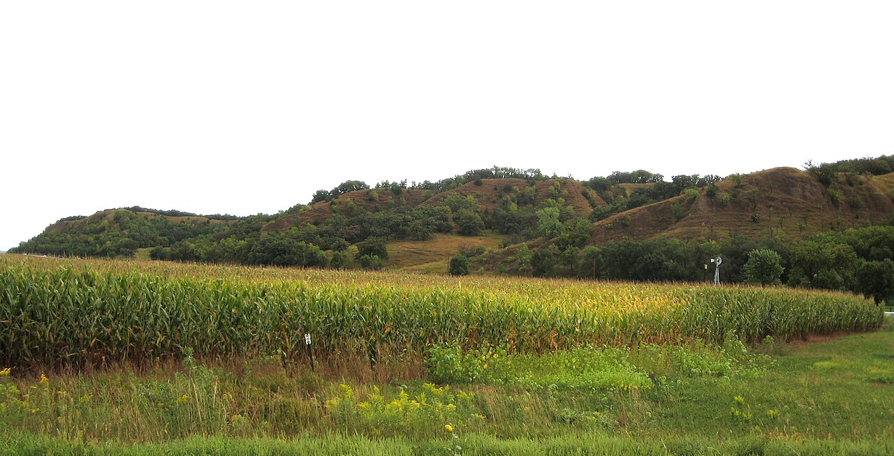
The Loess Hills along Iowa's western border are formed from wind-blown glacial silt deposits reaching 60 meters thick, creating a landscape of sharp ridges and deep ravines found in comparable form only along China's Yellow River. The Driftless Area in the northeast was bypassed by glaciers entirely, preserving a rugged terrain of limestone bluffs, caves, and cold-water trout streams.
Between these bookend landscapes, central Iowa's gently rolling Des Moines Lobe represents the most recent glaciation, with prairie potholes, moraines, and some of the richest soil on the planet.
Major Geographic Features
Loess Hills
Iowa's Loess Hills run 320 km along the Missouri River from Sioux City to south of Council Bluffs, with deposits reaching 60 meters thick — the deepest in the Western Hemisphere. The loess (wind-blown glacial silt) was deposited 18,000-12,500 years ago when prevailing winds carried fine sediment from the Missouri River floodplain. The resulting terrain features knife-edge ridges, steep bluffs, and a unique prairie ecosystem adapted to the well-drained silt.
Driftless Area
Northeastern Iowa's Driftless Area is a 40,000 sq km region (shared with Wisconsin, Minnesota, and Illinois) that was never glaciated, making it the only unglaciated terrain in the upper Midwest. The landscape features limestone bluffs rising 120 meters above the Mississippi and its tributaries, deep narrow valleys called coulees, cold-water streams, and over 1,000 caves. Pikes Peak State Park offers dramatic views of the Mississippi River 150 meters below.
Maquoketa Caves
Maquoketa Caves State Park in eastern Iowa protects 13 caves within a small area of Silurian dolomite bedrock. Dancehall Cave, the largest, extends 400 meters and is tall enough to walk through. A natural bridge spans 15 meters over a ravine. The caves were formed by dissolution of 420-million-year-old dolomite by slightly acidic groundwater over millions of years.
Prairie Potholes
North-central Iowa is part of the Prairie Pothole Region, where the retreating Des Moines Lobe glacier left thousands of shallow depressions that fill seasonally with water. These potholes, typically 1-10 hectares in size, are among the most productive wetlands in North America for breeding waterfowl. Iowa has lost over 95% of its original prairie potholes to drainage and agriculture.
Mississippi River Bluffs
Iowa's 530-km eastern border along the Mississippi River features limestone and dolomite bluffs rising up to 150 meters above the river. Effigy Mounds National Monument preserves 206 prehistoric mounds, including 31 in the shapes of bears and birds, built on blufftops overlooking the river. The bluffs are particularly dramatic in the Driftless Area near McGregor and Lansing.
Ocheyedan Mound
Ocheyedan Mound in northwestern Iowa rises 30 meters above the surrounding prairie — a kame (glacial meltwater deposit) that is the highest point in the immediate area. Nearby Hawkeye Point at 509 meters (1,670 feet) is the state's true highest point, situated on the gently undulating Iowan Erosion Surface. The contrast between these subtle glacial features and the dramatic Driftless bluffs illustrates Iowa's glacial geology.
Key Geographic Facts
- Hawkeye Point at 509 m (1,670 ft) is Iowa's highest point
- The Loess Hills deposits reach 60 meters thick, the deepest in the Western Hemisphere
- Iowa has lost over 95% of its original prairie potholes to agriculture
- The Driftless Area is the only unglaciated terrain in the upper Midwest
- Iowa borders the Mississippi River for 530 km along its eastern edge
Fun Facts
- Iowa's Loess Hills are matched in depth only by deposits along China's Yellow River
- The Driftless Area was somehow bypassed by every major glacial advance for over 2 million years
- Iowa's prairie soil is so rich that the black topsoil layer can reach 2 meters deep in some areas
- Effigy Mounds National Monument contains prehistoric mounds shaped like bears and birds, visible only from above
Final Thoughts
Iowa's geography is a masterclass in glacial and wind-deposited landforms. The Loess Hills, the Driftless Area, prairie potholes, and the vast till plains each represent different chapters of the Ice Age story. Far from featureless, Iowa contains landforms found almost nowhere else on Earth and preserves remnants of the tallgrass prairie that once covered a continent.
Test Your Knowledge!
Think you know your US state geography? Try our interactive quiz!
Play Country Quiz →