

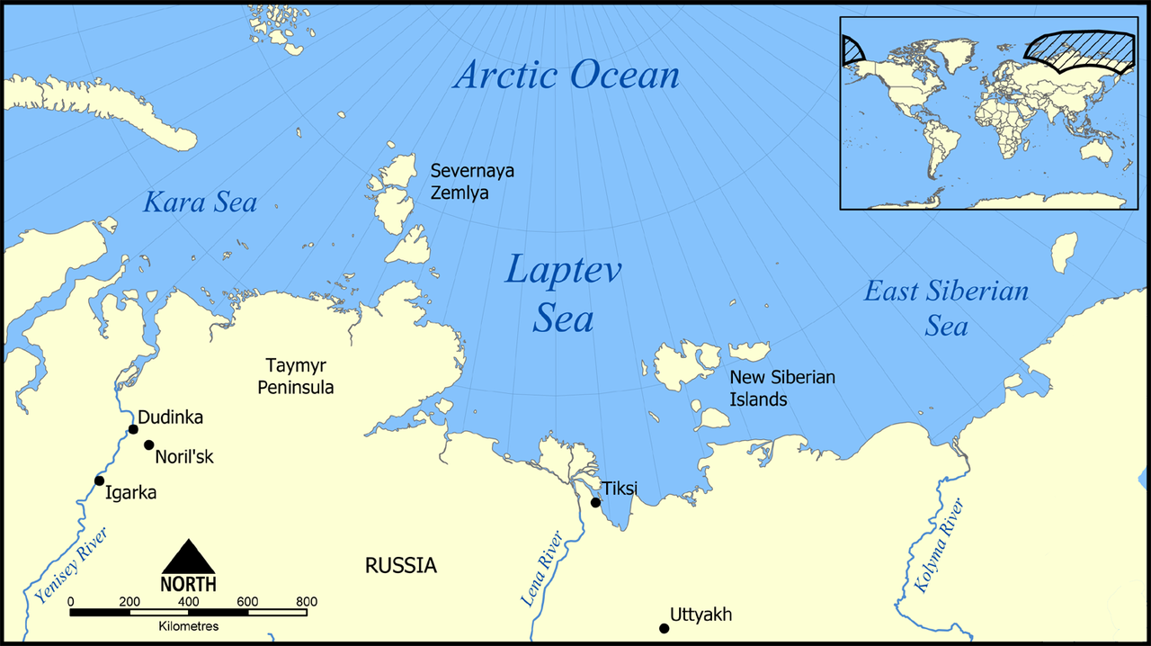
The Laptev Sea is a marginal sea of the Arctic Ocean, lying along the northern coast of Siberia between the Severnaya Zemlya archipelago and the New Siberian Islands. Covering approximately 662,000 square kilometers, it is one of the shallowest and least-explored seas in the Arctic, with an average depth of just 48 meters. Its name honors the Laptev cousins, Dmitry and Khariton, who explored the Siberian coast in the 18th century.
Introduction
The Laptev Sea has earned the nickname "the Arctic's ice factory" because it produces more new sea ice than any other region in the Arctic. Powerful offshore winds push newly formed ice away from the coast, creating persistent coastal polynyas (areas of open water) where new ice continually forms. This ice is then transported across the Arctic Ocean via the Transpolar Drift, eventually exiting through the Fram Strait into the North Atlantic — a journey that can take 2-3 years.
Geography & Dimensions
- Area: Approximately 662,000 km²
- Average Depth: 48 m
- Maximum Depth: 3,385 m (near continental slope)
- Major Rivers: Lena, Yana, Khatanga
The Laptev Sea sits between Severnaya Zemlya to the west and the New Siberian Islands to the east, with the vast Siberian lowlands to the south. The continental shelf here is extraordinarily broad and shallow — the southern portion has depths as low as 10-20 meters stretching hundreds of kilometers offshore. The shelf drops off sharply at the northern edge into the deep Arctic basin.
The Lena River, one of the world's longest rivers at 4,400 kilometers, empties into the Laptev Sea through a vast delta of over 32,000 square kilometers — one of the largest river deltas on Earth. The Lena contributes roughly 525 cubic kilometers of freshwater annually, along with massive quantities of sediment and organic carbon from thawing Siberian permafrost.
Ice Factory of the Arctic
- Ice Production: ~250,000 km² of new ice formed annually in polynyas
- Polynyas: Large, persistent open-water areas along the coast
- Transpolar Drift: Ice produced here drifts across the entire Arctic
- Transit Time: 2-3 years from Laptev Sea to Fram Strait
The Laptev Sea's role as the Arctic's ice factory is driven by its geography and wind patterns. Strong offshore winds from the Siberian landmass push sea ice away from the coast, creating large coastal polynyas — areas of open water where intense heat loss to the frigid atmosphere (-30 to -40°C in winter) causes rapid ice formation. As fast as ice forms, it is pushed away, and new ice forms in its place.
This conveyor-belt process produces an estimated 250,000 square kilometers of new sea ice each year. The ice is fed into the Transpolar Drift, a current that carries it across the Arctic Ocean toward Greenland and the Fram Strait, where it exits into the North Atlantic. Scientists have tracked sediment frozen into Laptev Sea ice all the way to Greenland, proving this cross-Arctic transport. The health of this ice production system is considered a key indicator of overall Arctic ice conditions.
Permafrost & Methane
- Subsea Permafrost: Extensive frozen sediment beneath the sea floor
- Methane Release: Observed bubbling and dissolved methane plumes
- Temperature: Subsea permafrost is warming and destabilizing
- Climate Risk: Potential for significant greenhouse gas release
The Laptev Sea's shallow shelf was dry land during the last Ice Age, when sea levels were over 100 meters lower. The permafrost that formed during that period is now submerged beneath the shallow sea floor, creating vast expanses of submarine permafrost. As the Arctic warms, this subsea permafrost is thawing, releasing methane — a potent greenhouse gas — that bubbles up through the water column.
Russian and international expeditions have documented extensive methane seepage across the Laptev Sea shelf, with some areas showing dramatic columns of gas bubbles rising from the sea floor to the surface. The total quantity of methane locked in subsea permafrost is enormous — potentially hundreds of gigatonnes — though the rate at which it will be released remains highly uncertain. Some scientists consider this a potential climate tipping point, while others believe the release will be gradual.
Marine Life & Ecosystem
- Key Species: Ringed seal, walrus, polar bear, Arctic cod
- Bird Populations: Important colonies on New Siberian Islands
- Biodiversity: Low species diversity but high seasonal productivity
- Lena Delta: Important habitat for fish and migratory birds
The Laptev Sea's marine ecosystem is shaped by extreme seasonality — months of polar darkness followed by 24-hour summer sunlight that triggers intense plankton blooms. Arctic cod is the dominant fish species, supporting populations of ringed seals, which in turn are hunted by polar bears. The Lena Delta and adjacent coastal areas provide critical habitat for migratory birds and spawning fish.
The New Siberian Islands on the sea's eastern boundary support colonies of seabirds and provide haul-out sites for walruses. The Laptev walrus population, once severely depleted by hunting, has partially recovered under protection. The sea also hosts occasional sightings of narwhals and bowhead whales. However, the extremely remote location and harsh conditions mean that the Laptev Sea's marine ecosystem remains one of the least studied in the Arctic.
Key Facts
- The Laptev Sea produces more new sea ice than any other region in the Arctic — approximately 250,000 km² annually.
- The Lena River delta emptying into the sea is one of the largest on Earth at over 32,000 km².
- Subsea permafrost beneath the Laptev Sea floor is thawing and releasing methane.
- Ice formed in the Laptev Sea takes 2-3 years to drift across the Arctic and exit through the Fram Strait.
- The sea's average depth is just 48 meters, making it one of the shallowest in the Arctic.
Fun Facts
- The Laptev Sea was dry land during the last Ice Age — woolly mammoth remains are regularly found eroding from coastal permafrost cliffs.
- Scientists have tracked sediment frozen into Laptev Sea ice all the way to the coast of Greenland, over 3,000 kilometers away.
- In October 2020, the Laptev Sea failed to freeze on schedule for the first time in recorded history, alarming climate scientists.
- The New Siberian Islands were once called the "Bone Islands" because of the enormous quantities of mammoth ivory found there.
Final Thoughts
The Laptev Sea may be one of the most remote and least-known seas on Earth, but its role in the global climate system is enormous. As the Arctic's primary ice factory and a vast reservoir of frozen methane, it holds two potential climate levers that could accelerate global warming well beyond current projections. What happens in the Laptev Sea over the coming decades will not stay in the Laptev Sea — its effects will be felt worldwide.
Test Your Knowledge!
Think you know the world's oceans and seas? Try our interactive geography quiz!
Play Geography Games →