
The Lut Desert, or Dasht-e Lut, in southeastern Iran holds the distinction of being the hottest place on Earth. NASA satellite measurements recorded a land surface temperature of 70.7 degrees Celsius (159.3°F) here in 2005, the highest ever documented anywhere on the planet.
Introduction
Designated a UNESCO World Heritage Site in 2016, the Lut Desert is a showcase of extreme geological processes. Its wind-sculpted ridges called yardangs, vast sand seas, and barren rocky plains create landscapes so alien that scientists have compared them to the surface of Mars.
Geography & Location
- Area: ~51,800 km²
- Location: Southeastern Iran (Kerman & Sistan-Baluchestan provinces)
- Elevation: 300–750 m above sea level
The Lut Desert sits in a large depression in southeastern Iran, bounded by mountain ranges that trap heat and block moisture. The desert stretches roughly 480 kilometers from north to south and 320 kilometers from east to west, making it one of Iran's largest deserts.
The Lut is divided into three main zones: a rocky plateau in the north, a massive field of yardangs (wind-eroded ridges) in the center called Kaluts, and a vast sand sea (Rig-e Yalan) in the southeast with dunes reaching 475 meters, among the tallest on Earth.
Extreme Temperatures
- Record Surface Temp: 70.7°C (159.3°F) in 2005
- Consecutive Records: Hottest spot 5 of 7 years (2003–2009)
- Summer Air Temp: Over 50°C regularly
Between 2003 and 2009, NASA's MODIS satellite instrument recorded the Lut Desert as the hottest land surface on Earth in five out of seven years. The record 70.7°C measurement far exceeds the commonly cited 56.7°C air temperature record from Death Valley. Note that land surface temperature differs from air temperature, but the Lut's extremes are unmatched.
The extreme heat is caused by the desert's dark volcanic rock surface, which absorbs solar radiation intensely, combined with the surrounding mountains that create a natural oven effect. Wind patterns can also concentrate heat in certain areas, creating localized hotspots.
Kaluts: Wind-Sculpted Ridges
- Area: ~120 km long, 40 km wide
- Height: Up to 75 m tall
- Formation: Wind erosion over millennia
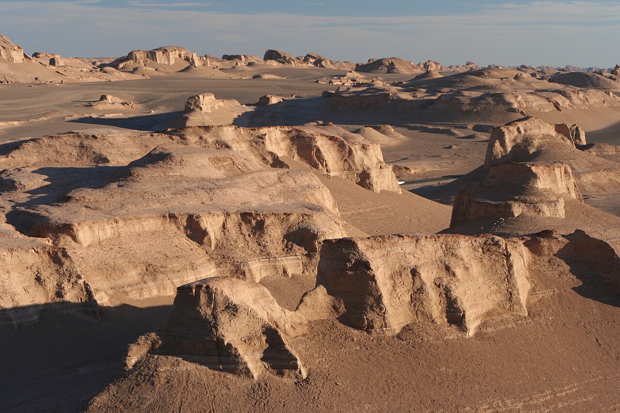
The Kaluts are the Lut's most spectacular feature: a vast field of parallel ridges sculpted by persistent winds blowing from the northwest. These yardangs stretch over 120 kilometers and resemble a city of giant sand castles or a corrugated landscape seen from space.
The ridges are composed of layers of sand, clay, and rock that have been differentially eroded by wind-borne sand particles. Some yardangs stand 75 meters tall. The formations create narrow corridors where wind speeds accelerate, further deepening the channels between them.
Wildlife & Adaptations
- Abiotic Zone: Central Lut is nearly lifeless
- Insects: Dark-colored beetles, ants at margins
- Microbes: Extremophile bacteria discovered
The central Lut Desert was long considered abiotic, meaning essentially devoid of life. However, recent expeditions have discovered insects, arachnids, and even small mammals at the desert's margins. Dark-colored beetles that absorb heat and foxes that hunt at night survive in the peripheral zones.
Scientists have found extremophile microorganisms that survive in the Lut's harsh conditions. These discoveries have implications for astrobiology, as they demonstrate life's ability to persist in conditions previously thought uninhabitable and inform the search for life on Mars and other extreme environments.
UNESCO Heritage & Tourism
- UNESCO Status: World Heritage Site since 2016
- Criteria: Outstanding example of geological processes
- Access: 4WD expeditions from Kerman
The Lut Desert was inscribed as a UNESCO World Heritage Site in 2016, recognized as an outstanding example of ongoing geological processes. The site encompasses the Kaluts yardang field, the sand sea, and the surrounding arid steppe, totaling about 2.28 million hectares.
Tourism to the Lut is growing but remains challenging. 4WD expeditions typically depart from the city of Kerman, and visits are best undertaken in the cooler months from November to March. The Shahdad area on the desert's western edge serves as the main gateway, with a Kaluts geopark offering guided tours of the formations.
Key Facts
- The Lut Desert holds the record for the highest land surface temperature ever recorded: 70.7°C (159.3°F).
- It was the hottest spot on Earth in 5 out of 7 years measured by NASA satellites (2003–2009).
- The Kaluts yardang field stretches over 120 km and contains ridges up to 75 m tall.
- Sand dunes in the Rig-e Yalan reach heights of up to 475 m, among the tallest on Earth.
- The Lut became a UNESCO World Heritage Site in 2016.
Fun Facts
- The Lut's dark volcanic surface acts like a frying pan, absorbing solar radiation far more efficiently than light-colored sand.
- Despite its extreme heat, the Lut occasionally receives snow in winter, which evaporates within hours.
- The yardangs of the Kaluts are so uniform they were initially mistaken for man-made structures in early satellite images.
- Scientists use the Lut as a Mars analog to test equipment and study how life might survive in extreme planetary conditions.
Final Thoughts
The Lut Desert is Earth at its most extreme, a landscape where temperatures shatter records and wind sculpts rock into alien formations. Its UNESCO recognition highlights not just its scientific importance but its raw beauty. For those who venture into its scorching expanse, the Lut offers an encounter with the very limits of life on our planet.
Test Your Knowledge!
Think you know your deserts? Try our interactive geography quiz!
Play Geographic Features Quiz →