
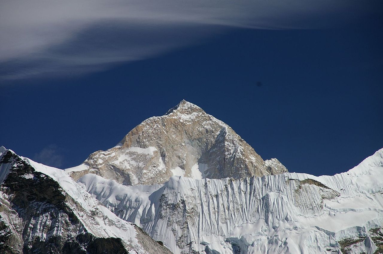
Makalu is the fifth-highest mountain in the world at 8,485 metres, standing on the Nepal–Tibet border about 19 km south-east of Everest. It is an isolated four-sided pyramid with sharp ridges on each edge, and its final section is generally rated the most technically demanding summit ridge of any 8,000-metre peak.
The shape is the whole point
Most great mountains are massifs — sprawling bodies with several summits and long connecting ridges. Makalu is not. It is a strikingly regular pyramid with four faces and four ridges, rising in isolation from the surrounding terrain, and that geometry defines both how it looks and how it climbs.
Isolation means it catches weather from every direction with nothing to shelter it, and wind on the upper pyramid is a defining hazard. The four ridges are all steep and narrow, so there is no easy walk-up aspect: every route involves sustained ground on an exposed edge.
The name is usually derived from Sanskrit Mahā Kāla, a form of Shiva, and glossed as the great black — a reference to the dark rock that shows through when wind strips the snow off the faces. That black rock is granite and gneiss, harder and steeper than the sedimentary layers that cap Everest, which is part of why Makalu holds its sharp shape.
Kangchungtse, and the col
Makalu is not entirely alone: Kangchungtse, or Makalu II, rises to about 7,678 metres just to the north, connected to the main peak by the Makalu La at around 7,400 metres. The normal route crosses that col, which is why base camp sits where it does.
Chomo Lonzo, at roughly 7,804 metres, stands further north across the Kangshung valley in Tibet — a striking peak that was first climbed by Jean Franco and Lionel Terray during the same 1955 French expedition, as an acclimatisation objective before Makalu itself. Climbing a 7,800-metre mountain to warm up is a fair indication of how that expedition was operating.
The hardest last hundred metres of any 8000er
On most 8,000-metre peaks the difficulty is altitude, weather and endurance; the actual climbing near the top is rarely technical. Makalu is the exception.
The standard route up the north-west ridge finishes with a section of steep rock and ice — the French Couloir and then a rock band immediately below the summit — that requires genuine technical climbing at above 8,400 metres, where a climber is moving slowly on supplementary oxygen in heavy gloves. Parties regularly reach the base of the final pitches and turn back, having run out of time or found the ground beyond what they can safely manage.
The consequence is a summit success rate well below that of Cho Oyu or Manaslu, and a reputation as the 8,000er that punishes climbers who arrive with high-altitude endurance but limited technical skill. It is frequently recommended as a serious objective after the more forgiving peaks rather than as an early one.
A French expedition that put everybody on top
Makalu was first climbed on 15 May 1955 by Lionel Terray and Jean Couzy of a French expedition led by Jean Franco.
What made the ascent remarkable was what followed. Over the next two days, every remaining member of the climbing team — including Franco himself and the sirdar Gyalzen Norbu — reached the summit. Nine climbers on top of a previously unclimbed 8,000-metre peak in three days was unprecedented, and it stood in sharp contrast to the pattern of the era, in which expeditions typically managed to place one or two men on the summit at the end of an exhausting siege.
The French had also made the first ascent of Annapurna five years earlier, in an epic that cost Maurice Herzog and Louis Lachenal most of their fingers and toes. Makalu was, by comparison, a model of efficient organisation, and it is often cited as the point at which Himalayan expedition practice matured.
The valley below, and a park with almost nobody in it
Makalu sits at the head of the Barun valley, which drains east into the Arun — one of the rivers that cuts clean through the Himalayan chain, because it is older than the mountains and has been cutting down as they rose.
Makalu Barun National Park protects the valley, and it is unusual among Nepali parks for how little visited it is. The approach involves a long walk in from the lower hills with no lodge infrastructure comparable to the Khumbu's, and no airstrip nearby of Lukla's convenience, so trekker numbers are a small fraction of those on the Everest or Annapurna circuits.
What that has preserved is an altitudinal gradient running from subtropical forest below 1,000 metres to the summit at 8,485 — one of the greatest continuous elevation ranges within a single protected area anywhere. The valley holds red panda, snow leopard, Himalayan tahr and an exceptional diversity of rhododendron and orchid species. The upper Barun is often described as one of the last relatively undisturbed high valleys in Nepal.
The Barun's glaciers and the water below
Makalu's ice drains into the Barun and thence the Arun, which cuts north to south clean through the Himalayan chain — one of the antecedent rivers older than the mountains themselves. The Arun's gorge is consequently one of the deepest transverse valleys in the range, and it carries a substantial volume of water down to the Sapta Koshi and eventually the Ganges plain.
That drop has attracted hydropower attention for decades. The Arun III project, long delayed and repeatedly redesigned, is among the larger schemes under construction in Nepal, and the valley's combination of steep gradient and reliable flow makes it one of the country's principal energy prospects. Balancing that against the ecological value of an unusually intact valley is the same argument playing out across the Himalayan rivers.
Makalu against Everest and Lhotse
The three mountains sit within 20 km of one another and are frequently seen in the same photograph from the east, but they are quite different objects:
- Everest is the highest and the most trafficked, with an established commercial route and a mature support industry.
- Lhotse is attached to Everest and shares its approach, so its ascent is bound up with a much busier mountain.
- Makalu is genuinely independent — its topographic prominence exceeds 2,300 metres, against Lhotse's 610 — and its approach, weather and technical difficulty are all its own.
Of the three, Makalu is the one a strong mountaineer is most likely to name as the interesting problem, and the one a commercial client is least likely to be offered.
The routes, and the ones still open
The normal route follows the north face and north-east ridge from a base camp on the Tibetan-facing side of the col, and it is the line almost all commercial attempts use. The original French route took the north-west ridge.
The mountain's great problem lines are elsewhere. The west pillar — a soaring buttress climbed by a French team in 1971 in one of the outstanding ascents of its decade — remains a serious undertaking. The south face is enormous, complex and has seen few successes relative to attempts.
Makalu resisted winter longer than most: the first winter ascent came on 9 February 2009, by Simone Moro and Denis Urubko, after a long series of failures by Polish, Italian and other parties. The combination of extreme cold, the sustained wind that the isolated pyramid attracts, and the technical final ridge makes the mountain a particularly unforgiving winter objective.
Where the name and the mountain diverge
Makalu's local names differ from the Sanskrit-derived one used internationally. In Tibetan it is Kamalung; the surrounding Nepali and Rai communities of the Arun valley have their own designations. As with much of the Himalaya, the name that reached the outside world came through survey conventions and Sanskritised forms rather than through the languages spoken at the foot of the mountain.
The Rai and Limbu peoples of eastern Nepal, and the Sherpa communities higher in the valleys, hold the surrounding peaks as sacred in the same way Kangchenjunga and Machapuchare are held elsewhere — though Makalu has never attracted a formal climbing prohibition of the kind those two carry.
One further consequence of the mountain's isolation is meteorological. Standing clear of neighbouring peaks, it generates its own lenticular cloud caps in high wind, visible from a long distance, which climbers read as a reliable signal that the summit ridge is unclimbable that day.
What the mountain is made of, and why it is here
Makalu, like the rest of the range, exists because the Indian plate is driving into Asia and has been for tens of millions of years. The collision has thickened and uplifted the crust along the suture, and the Himalaya are still rising at a rate of several millimetres a year — offset, roughly, by erosion.
The rock of Makalu's pyramid is largely leucogranite, intruded at depth and then brought to the surface by that uplift. Its resistance to weathering is why the mountain keeps its clean geometric faces while softer rock nearby erodes into broader forms.
The 2015 Gorkha earthquake, which killed thousands across Nepal and triggered the avalanche that struck Everest base camp, was a reminder that the same tectonics that built these peaks continue to act. Our guide to the Himalaya covers the collision and its consequences in more detail.
