
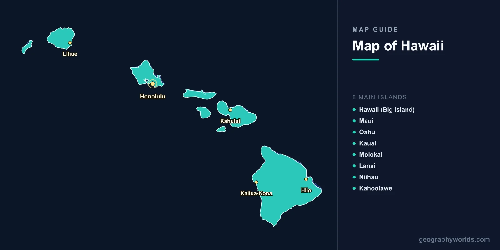
A map of Hawaii shows the most geographically isolated populated island chain on Earth, located 3,857 km from the nearest continent in the central Pacific Ocean. The Hawaiian archipelago stretches 2,400 km across the Pacific and includes 137 islands, though only 8 main islands are significant. The state covers 28,311 km2 with a population of 1.44 million. Hawaii's map reveals volcanic landscapes, tropical rainforests, dramatic sea cliffs, and the world's tallest mountain when measured from its ocean base.
Geography of Hawaii
Hawaii sits in the central Pacific Ocean between 18°N and 28°N latitude, approximately 3,857 km from California and 6,195 km from Japan. The archipelago was formed by a volcanic hotspot—a plume of magma rising through the Earth's mantle beneath the Pacific Plate. As the plate moves northwest at about 7 cm per year, new islands form over the hotspot while older ones erode and subside.
This geological process means the islands age from southeast to northwest. The Big Island (Hawaii) is the youngest and most volcanically active, while Kauai and Niihau in the northwest are the oldest of the main islands (approximately 5 million years old). The Northwestern Hawaiian Islands, extending another 2,000 km, include ancient, heavily eroded atolls and seamounts.
Mauna Kea on the Big Island rises 4,207 m above sea level, but measured from its base on the ocean floor, it stands 10,211 m tall—making it the tallest mountain on Earth from base to summit. Neighboring Mauna Loa (4,169 m) is the world's largest shield volcano by volume, containing an estimated 75,000 km3 of rock.
Hawaii's isolation has produced extraordinary biodiversity. Before human arrival, new species arrived at a rate of roughly one every 35,000 years, evolving into thousands of endemic species found nowhere else on Earth. Today, Hawaii is often called the "endangered species capital of the world."

The 8 Main Islands
- Hawaii (Big Island): 10,432 km2; largest island. Home to Kilauea (one of the world's most active volcanoes), Mauna Kea, and Mauna Loa. Contains 11 of the world's 13 climate zones. Population: 200,000. Main city: Hilo.
- Maui: 1,884 km2; "Valley Isle." Haleakala volcano (3,055 m) dominates the east; lush Iao Valley in the west. Population: 165,000. Known for whale watching and the road to Hana.
- Oahu: 1,545 km2; "The Gathering Place." Home to Honolulu (the state capital, population 350,000) and Pearl Harbor. Contains 70% of Hawaii's population (about 1 million). Waikiki Beach, Diamond Head crater, and North Shore surf breaks.
- Kauai: 1,430 km2; "Garden Isle." Oldest of the main islands. Features Waimea Canyon (16 km long, 900 m deep—"Grand Canyon of the Pacific") and the Na Pali Coast's dramatic sea cliffs. Mount Waialeale receives about 11,430 mm of rain annually—one of the wettest spots on Earth.
- Molokai: 673 km2; least commercially developed main island. Sea cliffs on the north shore reach 1,010 m—the world's tallest. Population: 7,300. Kalaupapa National Historical Park preserves the former leprosy settlement.
- Lanai: 364 km2; formerly the world's largest pineapple plantation. Population: 3,200. Now focused on luxury tourism.
- Niihau: 180 km2; privately owned by the Robinson family since 1864. Known as the "Forbidden Island." Population: ~70. Hawaiian is the primary language.
- Kahoolawe: 116 km2; uninhabited. Used as a military bombing target 1941–1990, now undergoing restoration. Sacred to Native Hawaiians.
Major Cities & Population Centers
- Honolulu: 350,000 (city), 980,000 (metro); state capital on southern Oahu. Hawaii's only true metropolitan area and the most remote major city in the world.
- Hilo: 45,000; Big Island's largest city on the rainy east coast. Gateway to Hawaii Volcanoes National Park.
- Kailua-Kona: 12,000; Big Island's dry west coast; tourism and coffee growing.
- Kahului: 30,000; Maui's commercial center and main airport.
- Lihue: 7,000; Kauai's county seat and main town.
Climate
- Overall: Tropical, moderated by northeast trade winds. Two seasons: a drier summer (May–October) and a wetter winter (November–April).
- Coastal temperatures: Remarkably stable year-round, averaging 24°C in winter and 27°C in summer. Sea-level temperatures rarely drop below 18°C or exceed 33°C.
- Elevation effects: Temperature drops about 6°C per 1,000 m. Mauna Kea summit regularly sees snow in winter.
- Rainfall extremes: Dramatic variation. Windward (northeast) slopes receive 2,500–11,000 mm annually; leeward (southwest) coasts may receive less than 250 mm. The Big Island has near-desert conditions on its western coast and tropical rainforest on its eastern slopes.
Key Facts About the Map of Hawaii
- Hawaii is the most isolated population center on Earth, over 3,800 km from the nearest continent.
- Mauna Kea (10,211 m from ocean base to summit) is the tallest mountain on Earth measured from base to peak.
- The Big Island contains 11 of the world's 13 climate zones.
- Mount Waialeale on Kauai averages 11,430 mm of rain per year—one of the wettest places on Earth.
- Kilauea volcano has been erupting almost continuously since 1983.
- Hawaii is the only US state that grows coffee commercially.
- The Northwestern Hawaiian Islands (Papahanaumokuakea Marine National Monument) protect 1.5 million km2 of ocean—one of the world's largest marine conservation areas.
Final Thoughts
The map of Hawaii reveals a volcanic archipelago of extraordinary geographic and ecological significance. From the active lava flows of Kilauea to the ancient eroded cliffs of Kauai's Na Pali Coast, and from Mauna Kea's snow-capped summit to the coral reefs of the Northwestern Hawaiian Islands, this island chain offers an unparalleled lesson in how volcanic hotspots create, shape, and eventually reclaim islands from the sea.
Test Your Geography Knowledge!
Think you know your maps? Try our interactive geography games!
Play Geography Games →