
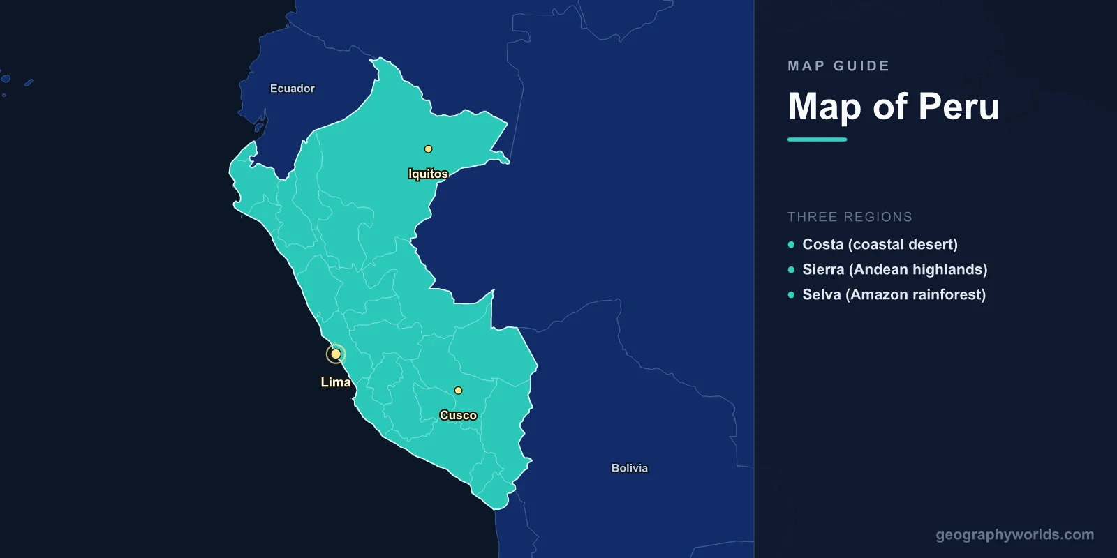
Peru is located on the western coast of South America, covering 1,285,216 square kilometers between 0° and 18°S latitude. The country is divided into three dramatic geographic zones: the narrow coastal desert (Costa), the towering Andes Mountains (Sierra), and the vast Amazon Rainforest (Selva). Peru is home to Machu Picchu, Lake Titicaca, and some of the highest cities in the world.
Introduction
Peru's geography is defined by extremes. The driest desert on Earth borders the deepest canyons in the Americas, which rise to snow-capped peaks above 6,000 meters before plunging into the world's largest rainforest. This three-way division of Costa, Sierra, and Selva shapes everything about Peru — its climate, agriculture, culture, and population distribution. Understanding these three regions is key to reading Peru's map.

Costa (Coastal Desert)
The Costa is a narrow strip of desert running the entire 2,414 km length of Peru's Pacific coastline. It makes up only about 11% of Peru's land area but holds more than half the population:
- Lima: Peru's capital and largest city (population ~10 million metro), located at 12.0°S, 77.0°W on the central coast. One of the driest capital cities in the world, receiving less than 15 mm of rain per year.
- Sechura Desert: The largest desert in Peru, covering 5,000 km² in the northern coastal region.
- Nazca Lines: Mysterious ancient geoglyphs etched into the desert floor near the city of Nazca, visible only from the air.
- Humboldt Current: The cold ocean current flowing north along the coast creates the arid conditions and supports one of the world's richest marine ecosystems.
Despite its aridity, the Costa is Peru's economic engine. River valleys cutting through the desert from the Andes create oases of irrigated agriculture, growing cotton, sugarcane, and rice. Major coastal cities include Trujillo, Chiclayo, Piura, and Arequipa (technically at the coast-Sierra transition).
Sierra (Andean Highlands)
The Sierra covers about 28% of Peru and contains the Andean mountain ranges that define the country's topography:
- Cusco: The former Inca capital at 3,400 m elevation, 13.5°S, 72.0°W. The gateway to Machu Picchu and the Sacred Valley. Population ~430,000.
- Huascaran: Peru's highest peak at 6,768 m, in the Cordillera Blanca. This is the highest tropical mountain in the world.
- Colca Canyon: At 3,270 m deep, one of the deepest canyons in the world, twice the depth of the Grand Canyon. Home to the Andean condor.
- Lake Titicaca: Shared with Bolivia at 3,812 m elevation, it is the highest navigable lake in the world and the largest lake in South America by volume. The Uros people live on floating reed islands on the lake.
The Sierra contains the headwaters of the Amazon River. The Apurimac River, rising near Arequipa, is now recognized as the Amazon's most distant source. Peru's Andes are divided into the Cordillera Blanca (White Range) and Cordillera Negra (Black Range) in the north, and the Cordillera Occidental and Oriental in the south.
Selva (Amazon Rainforest)
The Selva makes up roughly 60% of Peru's territory but holds only about 5% of the population:
- Iquitos: The world's largest city unreachable by road, located deep in the Amazon at 3.7°S, 73.3°W. Population ~470,000. Accessible only by river or air.
- Manu National Park: A UNESCO World Heritage Site and one of the most biodiverse places on Earth, containing over 1,000 bird species.
- Tambopata: Another premier biodiversity hotspot in southeastern Peru near the Bolivian border.
- Ucayali & Maranon Rivers: Major Amazon tributaries that merge near Iquitos to form the Amazon River proper.
Peru's Amazon region is further divided into the Selva Alta (High Jungle, 400-1,000 m) on the eastern Andean slopes and the Selva Baja (Low Jungle, below 400 m) in the flat Amazon basin. The transition zone between the Andes and the lowland rainforest, known as the cloud forest, is one of the richest ecosystems on the planet.
Machu Picchu & the Sacred Valley
Machu Picchu, Peru's most famous landmark, sits at 2,430 m on a mountain ridge above the Urubamba River valley, about 80 km northwest of Cusco. Built in the 15th century by the Inca emperor Pachacuti, it was abandoned during the Spanish conquest and remained unknown to the outside world until Hiram Bingham's 1911 expedition.
The Sacred Valley of the Incas runs along the Urubamba River between Cusco and Machu Picchu, containing important Inca sites including Ollantaytambo, Pisac, and Moray. The valley's fertile floor sits at approximately 2,800 m elevation, sheltered by surrounding peaks exceeding 4,000 m.
Departments & Administrative Divisions
Peru is divided into 25 departments (regions) plus the Lima Province. Key departments include Cusco (tourism hub), Arequipa (second-largest city), Loreto (largest by area, covering much of the Amazon), and Junin (central highlands mining region).
Key Facts
- Peru has three geographic zones: Costa (11% of area), Sierra (28%), and Selva (61%).
- Huascaran at 6,768 m is the highest tropical mountain in the world.
- Lake Titicaca at 3,812 m is the highest navigable lake in the world.
- Lima receives less than 15 mm of rain annually despite being the capital of a megadiverse country.
- Iquitos is the world's largest city that cannot be reached by road.
Fun Facts
- Peru has 84 of the world's 117 life zones, making it one of the most ecologically diverse countries on Earth.
- The Amazon River's most distant source was identified in southern Peru in the Apurimac River watershed.
- Machu Picchu was built without mortar — the Inca stonework is so precise that a knife blade cannot fit between the stones.
- Peru is the world's largest producer of quinoa and one of the top producers of coffee, asparagus, and copper.
Final Thoughts
Peru's map tells the story of a country defined by three radically different geographic zones stacked side by side. The bone-dry Costa, the soaring Sierra, and the vast Selva create a cross-section of landscapes unmatched in the Americas. From the Nazca Lines on the desert floor to Machu Picchu in the cloud forest to the floating islands of Lake Titicaca, Peru's geography is as extraordinary as its ancient civilizations.
Test Your Knowledge!
Think you know where things are on the map? Test your skills!
Play Geography Games →