
Marrakech, founded in 1070 and one of Morocco's four imperial cities, sits at an elevation of 466 meters on the Haouz Plain in central Morocco, roughly 40 km north of the highest peaks of the High Atlas Mountains. The city's famous red-ochre walls and buildings—earning it the name "The Red City"—derive their color from the local clay-rich soil of the plain.
Introduction
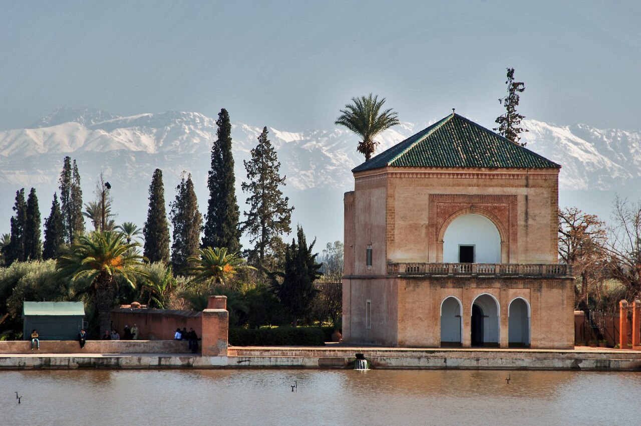
The geography of Marrakech is defined by the dramatic contrast between the flat, semi-arid Haouz Plain and the towering High Atlas Mountains that rise abruptly to the south, with Jebel Toubkal (4,167 m) visible from the city on clear days. This juxtaposition has shaped the city's water supply, agriculture, and culture for nearly a millennium, with snowmelt from the Atlas feeding an intricate network of underground channels that sustain the famous gardens and palm groves of this desert-edge metropolis.
Location & Setting
- Coordinates: 31.6295°N, 7.9811°W
- Elevation: 466 m above sea level
- Area: 230 km² (urban area)
- Country: Morocco
Marrakech lies at approximately 31.6°N latitude in the geographic center of Morocco, positioned between the Atlantic coast (170 km west) and the High Atlas Mountains (40 km south). The city occupies the Haouz Plain, a broad, flat alluvial basin formed by sediment eroded from the Atlas over millions of years. This plain extends roughly 150 km east-west and 40 km north-south between the mountains and the Jbilet Hills to the north.
The city's location was strategically chosen at the intersection of trade routes linking the Sahara to the south (via mountain passes), the Atlantic coast, and the northern cities of Fez and Meknes. The Haouz Plain's relatively fertile soils, combined with water from the Atlas, created the conditions for the extensive palm groves (Palmeraie) that historically surrounded the city—over 100,000 date palms in an area covering roughly 13,000 hectares.
Terrain & Landscape
- Haouz Plain: Flat alluvial basin, 400–500 m elevation
- High Atlas: Mountain barrier to south, peaks to 4,167 m
- Jbilet Hills: Low hills (500–800 m) to the north
- Palmeraie: 13,000-hectare palm grove northeast of medina
The Haouz Plain is remarkably flat, with gentle slopes of less than 1% across most of the city. The soil is predominantly red clay and alluvial deposits—the distinctive terre rouge that gives Marrakech its famous color. This red earth, rich in iron oxide, has been used as a building material for centuries and is the source of the uniform salmon-pink hue of the medina walls and traditional architecture.
To the south, the High Atlas Mountains rise dramatically from the plain, gaining over 3,700 m of elevation in just 40 km—one of the steepest mountain fronts in North Africa. The Ourika Valley and Toubkal massif are the nearest major Atlas features. To the north, the Jbilet Hills are an ancient, eroded mountain range of Paleozoic schists and granites, rarely exceeding 800 m but creating a topographic barrier that influences local wind patterns and rainfall distribution.
Climate & Weather
- Climate Type: Semi-arid (Köppen BSk)
- Summer Temps: 35–45°C (June–August)
- Winter Temps: 5–18°C (December–February)
- Annual Rainfall: ~240 mm
Marrakech has a semi-arid climate with hot, dry summers and mild winters. Summer temperatures routinely exceed 40°C and can reach 48°C during heat waves driven by hot air from the Sahara (the chergui wind). The diurnal temperature range is significant, with summer nights dropping 15–20°C below daytime highs. Winters are mild by day but can be cold at night, with occasional frost.
Rainfall is sparse and highly variable, averaging around 240 mm per year, concentrated between October and April. The Atlas Mountains play a crucial role in the city's water cycle—they intercept moisture-laden Atlantic air masses, receiving 600–800 mm of precipitation (much as snow above 2,000 m) that feeds the rivers and aquifers on which Marrakech depends. The Haouz Plain itself lies in the rain shadow of the Jbilet Hills for northerly weather systems, contributing to its aridity.
Natural Hazards & Geology
- Seismic Risk: Moderate-high; Atlas fault system active
- Flood Risk: Flash floods from Atlas wadis during heavy rain
- Drought Risk: High; recurring water scarcity
- Heat Extremes: Temperatures exceeding 45°C during Saharan heat waves
Marrakech faces significant seismic risk from the convergence of the African and Eurasian tectonic plates, which drives the ongoing uplift of the Atlas Mountains. The devastating September 2023 Al Haouz earthquake (magnitude 6.8), centered about 70 km southwest of Marrakech in the High Atlas, killed over 2,900 people, damaged the historic medina, and demonstrated the region's vulnerability to large seismic events.
Flash flooding is another major hazard, occurring when intense rainfall in the Atlas Mountains sends torrents down normally dry wadis (river beds) onto the Haouz Plain. These events can be rapid and destructive. Drought is a chronic challenge—groundwater levels in the Haouz aquifer have dropped dramatically due to over-extraction for agriculture and urban use, and climate projections suggest the region will become significantly hotter and drier in coming decades.
Rivers & Waterways
- Tensift River: Main river, flows west 250 km to Atlantic
- Khettaras: Underground water channels, some 900+ years old
- Ourika River: Atlas tributary feeding Haouz Plain
- Haouz Aquifer: Major groundwater basin beneath the plain
The Tensift River, Marrakech's primary river, flows westward roughly 250 km from the High Atlas to the Atlantic Ocean north of Essaouira. Within the city it is typically a modest, seasonally variable stream that can swell dramatically during winter rains. The Ourika, Rheraya, and other Atlas rivers flow northward onto the Haouz Plain, where much of their water infiltrates the alluvial aquifer before reaching the Tensift.
Marrakech's most remarkable geographic feature is its khettara system—an ancient network of underground water channels (similar to Persian qanats) that tap the Haouz aquifer and deliver water to the city by gravity. At their peak, over 500 khettaras supplied Marrakech, some extending over 15 km. While most have dried up due to falling water tables, they represent an extraordinary adaptation to semi-arid geography. Today, the city relies primarily on the Lalla Takerkoust Dam on the N'Fis River and the Hassan I Dam, supplemented by groundwater pumping.
Key Facts
- Marrakech sits at 466 m on the Haouz Plain, just 40 km from the 4,167 m summit of Jebel Toubkal.
- The city receives only ~240 mm of rain annually but benefits from Atlas Mountain snowmelt.
- Over 500 khettaras (underground channels) once supplied water to the city by gravity alone.
- The 2023 Al Haouz earthquake (M6.8) demonstrated the seismic risk from the Atlas fault system.
- The distinctive red color of Marrakech comes from iron-oxide-rich clay in the local Haouz Plain soil.
Fun Facts
- Marrakech's Palmeraie once contained over 100,000 date palms across 13,000 hectares.
- Jebel Toubkal, visible from Marrakech, is the highest peak in North Africa at 4,167 m.
- The temperature in Marrakech can swing 20°C between afternoon and nighttime in summer.
- The city's khettara water channels use the same technology as Persian qanats, dating back over 2,500 years.
Final Thoughts
Marrakech's geography tells the story of human ingenuity in a challenging environment—a vibrant city sustained for nearly a millennium on a semi-arid plain through clever management of Atlas Mountain water resources. The dramatic backdrop of North Africa's highest peaks, the distinctive red earth, and the ongoing tectonic forces that both built the Atlas and threaten the city with earthquakes make Marrakech a compelling study in how geography shapes urban civilization at the edge of the Sahara.
Test Your Knowledge!
Think you know world city geography? Test your knowledge with our interactive games!
Play Geography Games →