

The Snake River is the largest tributary of the Columbia River and one of the most powerful rivers in the American West, flowing 1,078 miles from its source in Yellowstone National Park through the volcanic landscapes of southern Idaho, into Hells Canyon on the Idaho-Oregon border, and across southeastern Washington to its confluence with the Columbia.
Introduction
The Snake is a river of superlatives and contradictions. It has carved the deepest river gorge in North America, supports one of the most productive agricultural regions in the world, and generates enormous amounts of hydroelectric power — yet its once-legendary salmon runs have been pushed to the brink of extinction by the very dams that power the region.
Geography & Dimensions
- Length: 1,078 miles (1,735 km)
- Drainage Basin: 108,000 sq miles (6 states)
- Average Discharge: 54,830 cu ft/s at mouth
- Source: Yellowstone National Park, Wyoming
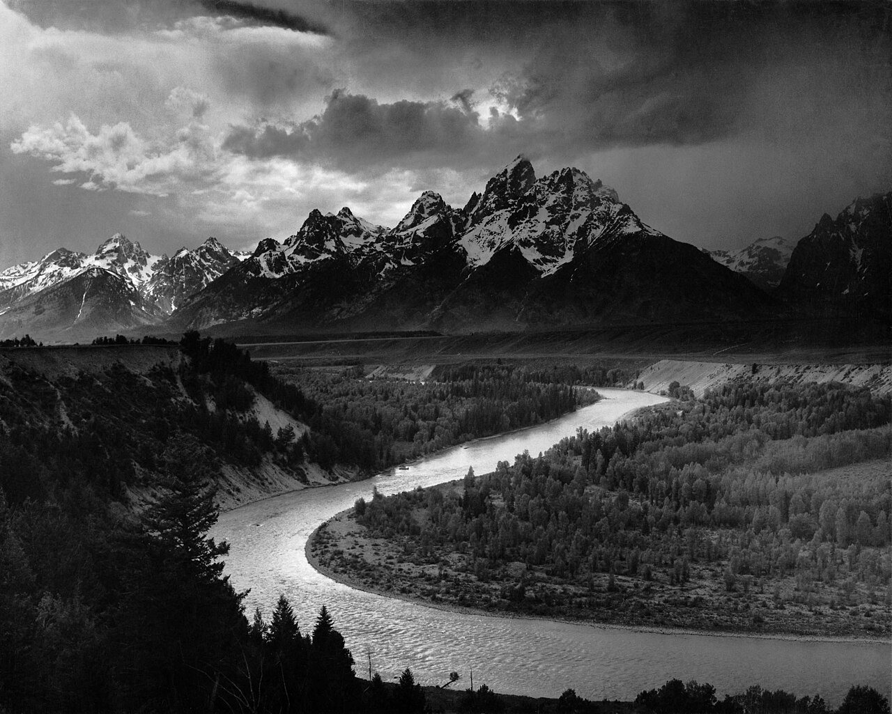
The Snake River begins in Yellowstone National Park, flows south through Jackson Hole beneath the Teton Range — one of the most photographed mountain landscapes in the world — then curves west across the Snake River Plain of southern Idaho. This broad volcanic plateau, formed by the passage of the Yellowstone hotspot, creates a landscape of lava fields, craters, and dramatic spring-fed waterfalls.
At Twin Falls, Idaho, the river plunges 212 feet over Shoshone Falls, often called the "Niagara of the West." Below Twin Falls, the Snake enters Hells Canyon, the deepest river gorge in North America at over 7,900 feet measured from the summit of He Devil Peak to the river below. The canyon stretches 125 miles along the Idaho-Oregon border.
Hells Canyon
- Depth: Over 7,900 feet (deepest gorge in North America)
- Length: 125 miles
- Rapids: Class III–V whitewater
- Wilderness: Hells Canyon Wilderness: 215,000 acres
Hells Canyon is deeper than the Grand Canyon, though narrower and less widely known. The canyon was carved by the Snake River over millions of years through ancient volcanic and metamorphic rock. Its walls rise from a river elevation of about 1,400 feet to peaks exceeding 9,300 feet on both the Idaho and Oregon sides, creating a stunning vertical landscape.
The Hells Canyon National Recreation Area and Wilderness, established in 1975, protects 652,000 acres including 215,000 acres of designated wilderness. The canyon supports bighorn sheep, mountain goats, black bears, and over 300 species of birds. Whitewater rafting through the canyon, with rapids up to Class V, is one of the premier river experiences in the American West.
Salmon & Dam Debate
- Historic Salmon Runs: Over 2 million fish annually
- Current Runs: Often fewer than 10,000 wild fish
- Lower Snake Dams: 4 dams proposed for removal
- Endangered Species: Snake River sockeye, chinook, steelhead all listed
The Snake River once supported some of the largest salmon runs in the Columbia Basin, with over 2 million fish returning annually to spawn in headwater streams hundreds of miles inland. Snake River sockeye salmon, chinook salmon, and steelhead trout are all listed under the Endangered Species Act. In some years, fewer than 10 wild sockeye salmon have returned to Redfish Lake in the Sawtooth Mountains of central Idaho.
The four lower Snake River dams — Ice Harbor, Lower Monumental, Little Goose, and Lower Granite — are at the center of one of the most contentious environmental debates in the Pacific Northwest. Dam removal advocates argue that free-flowing conditions are necessary for salmon recovery. Opponents cite the dams' value for irrigation, navigation, and power generation. The debate involves billions of dollars, treaty obligations to Native American tribes, and the survival of species.
Agriculture & Irrigation
- Snake River Plain: One of the most productive ag regions in the US
- Crops: Potatoes, sugar beets, wheat, barley, dairy
- Aquifer: Eastern Snake Plain Aquifer — vast underground reservoir
- Irrigation: Over 3.8 million acres in Idaho
The Snake River Plain is one of the most productive agricultural regions in the United States. Idaho produces roughly one-third of the nation's potatoes, and the Snake River irrigates over 3.8 million acres of farmland. Sugar beets, wheat, barley, and dairy operations also depend on Snake River water. The Thousand Springs area, where the Eastern Snake Plain Aquifer discharges through canyon walls, is one of the most remarkable hydrological features in the country.
The Eastern Snake Plain Aquifer, one of the most productive aquifers in the world, is interconnected with the Snake River. Irrigation practices have drawn down the aquifer in many areas, reducing spring flows that sustain the river during dry months. Balancing agricultural water use with aquifer sustainability and environmental flows is one of Idaho's most pressing water management challenges.
Significance & Future
- Yellowstone Connection: Originates in the world's first national park
- Climate Change: Reduced snowpack threatening summer flows
- Tribal Rights: Nez Perce and Shoshone-Bannock treaty fishing rights
The Snake River connects some of the most iconic landscapes in the American West — from Yellowstone and the Tetons to Hells Canyon and the Columbia Plateau. Its waters sustain agriculture, cities, fish, and wildlife across six states. The river's future is inextricably linked to the outcome of the dam removal debate and to broader questions about water allocation in a warming climate.
The Nez Perce and Shoshone-Bannock tribes hold treaty rights to fish in the Snake River basin, and salmon are central to their cultural and spiritual identity. Federal trust obligations to these tribes add a legal and moral dimension to the dam removal debate. Climate change is projected to reduce snowpack by 20 to 40 percent by mid-century, further stressing a river system already stretched thin.
Key Facts
- The Snake River is 1,078 miles long, the largest tributary of the Columbia.
- Hells Canyon is the deepest river gorge in North America at over 7,900 feet.
- Historic salmon runs of 2 million fish have declined to sometimes fewer than 10,000.
- Idaho produces one-third of the nation's potatoes using Snake River water.
- Four lower Snake River dams are proposed for removal to save endangered salmon.
Fun Facts
- Shoshone Falls on the Snake River is 212 feet high — 36 feet higher than Niagara Falls.
- The Thousand Springs area of the Snake River Canyon features massive springs gushing from canyon walls, fed by an aquifer that collects water from over 100 miles away.
- In 1993, only one wild sockeye salmon — nicknamed "Lonesome Larry" — returned to Redfish Lake in Idaho.
- The Snake River got its name from the S-shaped hand gesture the Shoshone people used to mimic the river's shape, which European explorers mistakenly interpreted as a snake.
Final Thoughts
The Snake River is a microcosm of the tensions that define water management in the American West — agriculture versus environment, dams versus fish, economic development versus ecological preservation. The decisions made about this river in the coming years will reverberate across the Pacific Northwest for generations.
Test Your Knowledge!
Think you know America's rivers? Try our interactive quiz!
Play Geography Games →