
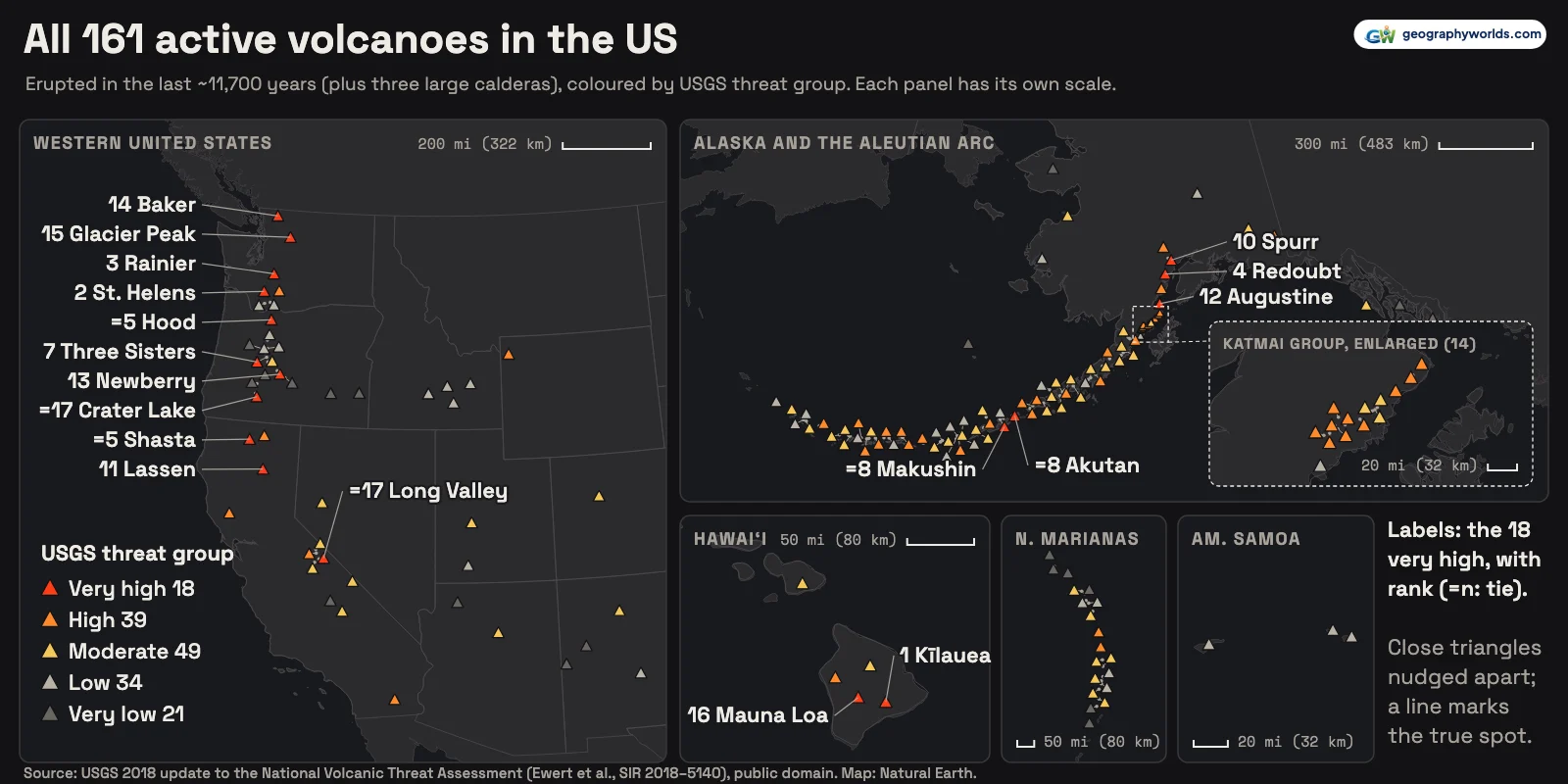
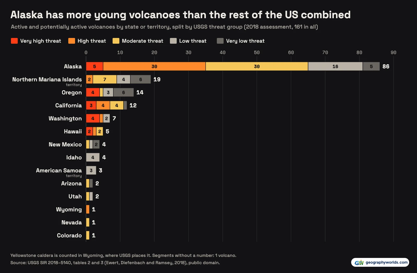
The US Geological Survey counts 161 active or potentially active volcanoes in the United States and its Pacific territories, in its 2018 national volcanic threat assessment, the latest edition. Here "active" means a volcano that has erupted within roughly the last 11,700 years, plus three large caldera systems (Yellowstone, Long Valley and Valles); it does not mean erupting today. Alaska has 86 of them, Oregon 14, California 12, Washington 7 and Hawaii 5, with 15 more in seven other western states and 22 in the Northern Mariana Islands and American Samoa. The USGS rates 18 as very high threat, led by Kīlauea (threat score 263), Mount St. Helens (235) and Mount Rainier (203). On 16 October 2026 two US volcanoes were erupting: Kīlauea in Hawaii and Great Sitkin in the Aleutian Islands.
The ranking does not say which volcano will erupt next. The authors, John Ewert, Angela Diefenbach and David Ramsey, write that it "is not a forecast or indication of which volcanoes are most likely to erupt next". It measures how much harm an eruption could do, which depends as much on who and what lies downwind and downstream as on the volcano itself.
How the USGS decides which volcanoes are most dangerous
Each volcano in the 2018 assessment (Scientific Investigations Report 2018–5140) is scored on 15 hazard factors, such as its largest known eruption, how often it erupts, whether it has produced pyroclastic flows or lahars and whether it has shown unrest (earthquakes, ground swelling, gas) since its last eruption, and on 9 exposure factors, such as the population nearby, airports, power and transport lines and the air traffic overhead. The hazard factors are added up, the exposure factors are added up, and the two sums are multiplied. Scores run from 263 for Kīlauea down to zero for 7 remote volcanoes, 6 of them in the Northern Mariana Islands and one in Alaska.
The scores are then cut into five groups: 18 very high, 39 high, 49 moderate, 34 low and 21 very low. There is a clear gap at the top. The lowest very-high-threat score is 129, shared by Crater Lake and Long Valley Caldera; the highest score in the high group is 117.
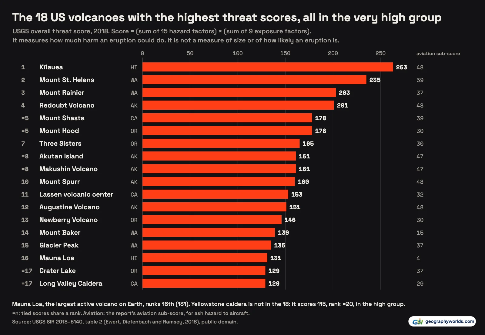
Because exposure multiplies hazard, threat is not the same as size. Mauna Loa, which the USGS calls "the largest active volcano on our planet", ranks 16th with 131. Yellowstone is not in the top group at all: it scores 115, tied with Alaska's Iliamna for =20 (21st in the report, which numbers ties in sequence), in the high group. Eleven of the 18 are in Washington, Oregon and California, five are in Alaska and two are on the Island of Hawaiʻi.
| Rank | Volcano | State | Threat score | Aviation sub-score | Alert level, 16 October 2026 |
|---|---|---|---|---|---|
| 1 | Kīlauea | Hawaii | 263 | 48 | Watch (orange) |
| 2 | Mount St. Helens | Washington | 235 | 59 | Normal (green) |
| 3 | Mount Rainier | Washington | 203 | 37 | Normal (green) |
| 4 | Redoubt Volcano | Alaska | 201 | 48 | Normal (green) |
| =5 | Mount Shasta | California | 178 | 39 | Normal (green) |
| =5 | Mount Hood | Oregon | 178 | 30 | Normal (green) |
| 7 | Three Sisters | Oregon | 165 | 30 | Normal (green) |
| =8 | Akutan Island | Alaska | 161 | 47 | Normal (green) |
| =8 | Makushin Volcano | Alaska | 161 | 47 | Normal (green) |
| 10 | Mount Spurr | Alaska | 160 | 48 | Normal (green) |
| 11 | Lassen volcanic center | California | 153 | 32 | Normal (green) |
| 12 | Augustine Volcano | Alaska | 151 | 48 | Normal (green) |
| 13 | Newberry Volcano | Oregon | 146 | 30 | Normal (green) |
| 14 | Mount Baker | Washington | 139 | 15 | Normal (green) |
| 15 | Glacier Peak | Washington | 135 | 37 | Normal (green) |
| 16 | Mauna Loa | Hawaii | 131 | 4 | Normal (green) |
| =17 | Crater Lake | Oregon | 129 | 37 | Normal (green) |
| =17 | Long Valley Caldera | California | 129 | 29 | Normal (green) |
Why the count is 161, and not 169 or some other number
The list starts from the Smithsonian Institution's Global Volcanism Program database of volcanoes active in the Holocene, the epoch that began 11,650 calendar years before 1950. The USGS adds the three long-lived calderas and then reviews every system against new dating. The first assessment, in 2005, had 169 volcanoes. In the 2018 update, 40 volcanic systems had their inclusion status changed. In the lower 48 states, new research removed 14 volcanoes, nearly all of them very-low-threat volcanoes in Oregon, California and Utah, and added three, among them Salton Buttes in California and Soda Lakes in Nevada; with some systems merged or renamed, the lower-48 count fell by 13 to 48. Alaska's count fell by 4 to 86, the Northern Mariana Islands rose by 6 to 19, and American Samoa's 3 volcanoes were added after being "mistakenly left out" in 2005. The net change was eight fewer, giving 161.
A second count of 161 appears on the USGS Volcano Hazards Program's own live status feed, but it is not quite the same list. It has no entry for Korovin Volcano, Wide Bay cone, St. Paul Island and Golden Trout Creek volcanic field, and it includes Espenberg, Folsoms Bluff, Isanotski and Kamaʻehuakanaloa, the last being the submarine volcano off the Island of Hawaiʻi that the report's eruption table calls Lōʻihi seamount. Its threat labels differ too: 23 volcanoes carry a different group on the feed than in the report, and 22 of them are volcanoes the 2018 report moved between groups, still shown in their earlier group. The map on this page follows the published report.
The same feed gives each volcano's alert level. On 16 October 2026, four were above normal, 62 were at green / Normal, and 95 were "unassigned", which means the ground instruments at those volcanoes cannot establish a normal background level, as the Alaska Volcano Observatory explains. 69 of the 95 unassigned volcanoes are in Alaska or the Northern Mariana Islands.
The Cascades: ten of the eighteen in one line
Counting all of Washington, the Oregon Cascades and three northern California volcanoes (Shasta, Lassen and Medicine Lake), the Cascade Range has 21 of the 161 volcanoes and 10 of the 18 very-high-threat ones, strung over about 570 miles (920 km) from Mount Baker near the Canadian border to Lassen in California. The report's explanation is that these explosive, often snow- and ice-covered volcanoes can send their hazards long distances into densely populated and highly developed areas.
Mount St. Helens ranks second with 235 and has the highest aviation sub-score of any US volcano, 59. Its eruption on 18 May 1980 "laid waste to over 200 square miles of forest and killed 57 people", as a USGS Volcano Watch article recalled. Our guide to the Mount St. Helens eruption tells that day in detail.

Mount Rainier is third on 203. The USGS says its greatest potential hazard is a lahar, a volcanic mudflow; large lahars from Rainier have reached the Puget Sound lowlands, where Tacoma and the towns of the Puyallup valley now stand. Mount Shasta and Mount Hood tie on 178. Oregon's other three, Three Sisters, Newberry and Crater Lake, complete a list in which Washington and Oregon have four each.

Alaska: 86 volcanoes under the North Pacific air routes
Alaska holds 53% of the country's young volcanoes: 5 very high, 30 high, 30 moderate, 16 low and 5 very low. It supplies 77% of the high group and 30 of the 49 moderate ones. The report's explanation is aviation: Alaska's generally more active and more explosive volcanoes can have a substantial effect on national and international air traffic. The report's aviation sub-score, which combines a volcano's explosive history with the air traffic exposed to its ash, picks this out: 9 of the 11 volcanoes scoring 47 or more are Alaskan.
The five very-high-threat volcanoes are Redoubt, Mount Spurr and Augustine around Cook Inlet, west and southwest of Anchorage, and Akutan and Makushin in the eastern Aleutians, which tie on 161. Great Sitkin, a high-threat volcano, was at orange / Watch on 16 October 2026: the Alaska Volcano Observatory reports that its current lava eruption began in July 2021 and has filled most of the summit crater, 26 miles (42 km) from the town of Adak. Shishaldin was at yellow / Advisory. Fourpeaked Mountain is the only volcano that rose more than one group in 2018, from low to high, after it erupted in 2006.
Hawaiʻi: the top-ranked volcano, and the largest
Kīlauea's 263 is the highest score in the country. In the spring and summer of 2018, the report notes, lava from fissures on its Lower East Rift Zone inundated communities in lower Puna. It is erupting again: the USGS says it has been erupting on and off within its summit caldera since 23 December 2024, and it was at orange / Watch on 16 October 2026. For the geology behind it, see our guide to Kīlauea.
Mauna Loa last erupted in November and December 2022, yet its threat score of 131 is half of Kīlauea's. The gap shows most in the aviation sub-score, built from a volcano's record of explosive eruptions and the air traffic near it: 4 for Mauna Loa against 48 for Kīlauea. Hualālai, above the Kona coast, ranks 23rd, in the high group, and Haleakalā on Maui and Mauna Kea are moderate. None of Hawaii's 5 is below moderate.
Calderas, desert cones and Pacific seamounts: the other 49
The rest of the West has 27 volcanoes, and only one of them is very high threat: Long Valley Caldera in eastern California. Its neighbours Mono-Inyo Craters are high, and so are Clear Lake north of San Francisco and Salton Buttes, a group of lava domes at the south end of the Salton Sea added in 2018 after new dating showed Holocene eruptions. Yellowstone is high; New Mexico's Valles Caldera, Colorado's Dotsero and Nevada's Soda Lakes are moderate; Idaho's 4, including Craters of the Moon, are all low.
The 19 Northern Mariana Islands volcanoes include two high-threat islands, Pagan (79) and Agrigan (67), and 6 that score zero, the lowest of any US volcanoes. One of those, Ahyi Seamount, was at yellow / Advisory on 16 October 2026, with plumes of discoloured water seen by satellite. American Samoa's 3 volcanoes are all low threat.
You can download the data as a CSV: every volcano's rank, threat group, both scores, coordinates and its alert level on 16 October 2026. Want to plot your own state against Alaska? Parity will turn the file into a chart without any code. For a wider view of how these compare with Vesuvius, Merapi and the rest, read our ranking of the most dangerous volcanoes in the world.
Sources
- Ewert, J.W., Diefenbach, A.K., and Ramsey, D.W., 2018, 2018 update to the U.S. Geological Survey national volcanic threat assessment: USGS Scientific Investigations Report 2018–5140: tables 2 and 3: all 161 volcanoes, threat scores, aviation sub-scores, threat groups and coordinates; a US Government work, public domain (the report's own notice: 'for the most part, is in the public domain')
- USGS Volcano Hazards Program, volcano status feed (vhpstatus) and Hazard Notification System elevated-volcano list: alert levels and aviation colour codes, fetched 2026-10-16; public domain
- Natural Earth: admin-1 states and provinces (1:50m), land and minor islands (1:10m), v5.1.2: public domain