
The great trade cities of the ancient world were not random settlements but geographic necessities. Every major trading hub existed because of a specific geographic advantage: an oasis in the desert, a natural harbor on the coast, a mountain pass controlling access to a valley, or a river junction connecting multiple transportation networks.
Introduction
From the Silk Road oases of Central Asia to the Mediterranean port cities, from the incense routes of Arabia to the spice markets of Southeast Asia, ancient trade cities demonstrate that commerce has always followed geography. Understanding these cities reveals the geographic logic that has driven human exchange for millennia.
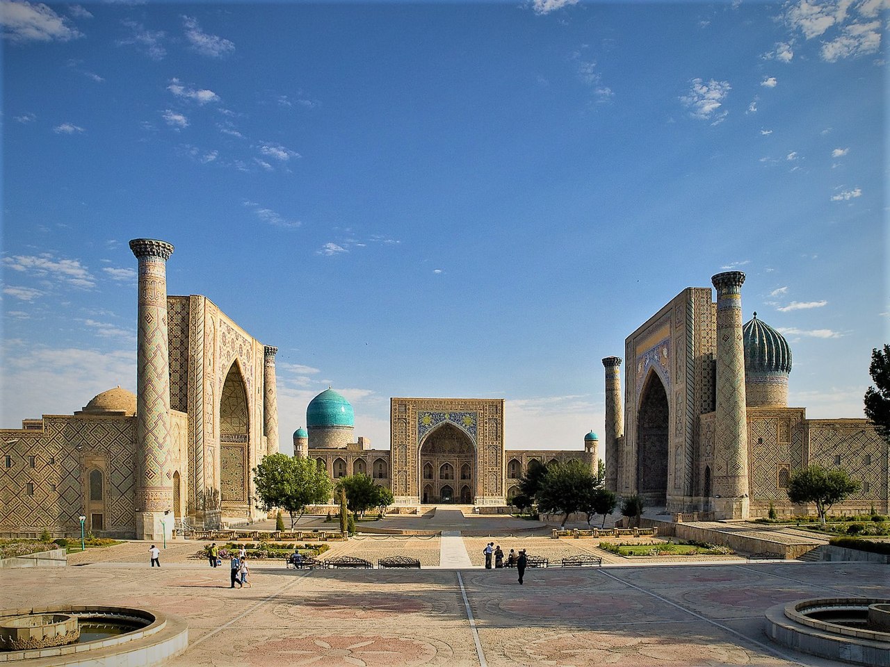
Geographic Context
- Silk Road Era: ~2nd century BC - 15th century AD
- Maritime Routes: Mediterranean, Indian Ocean, South China Sea
- Key Commodities: Silk, spices, gold, incense, salt, gems
The ancient world's trade networks were shaped by geographic corridors: the Silk Road through Central Asian deserts and mountain passes, the Indian Ocean monsoon routes, the Mediterranean Sea lanes, the trans-Saharan caravan routes, and the river systems of Mesopotamia, Egypt, and China.
Trade cities emerged at geographic chokepoints: where routes converged, where caravans needed to resupply, where goods had to be transferred between different transport modes (ship to camel, camel to riverboat), or where political borders required taxation. Each city's wealth was proportional to its geographic indispensability.
Key Events
- Petra Peak: 4th century BC - 1st century AD
- Palmyra Peak: 1st-3rd centuries AD
- Samarkand Peak: 14th century under Timur
- Venice Peak: 13th-15th centuries
Petra, carved into red sandstone cliffs in modern Jordan, controlled the incense trade route between Arabia and the Mediterranean. Its location in a narrow canyon (the Siq) made it both defensible and a mandatory stopping point for caravans. At its peak, Petra's Nabataean Kingdom controlled water sources across the desert that gave them a geographic monopoly on trade.
Venice emerged as a geographic genius of European trade. Built on 118 islands in a lagoon, it was virtually invulnerable to land-based attack while commanding access to the Adriatic and eastern Mediterranean. Venice's position as the western terminus of Silk Road goods reaching Constantinople made it the richest city in medieval Europe.
Territorial Changes
- Routes Shifted: As empires rose and fell
- New Technologies: Maritime navigation reduced overland route importance
- Colonial Era: European maritime powers bypassed traditional trade cities
Trade cities rose and fell with the routes they served. When the Mongol Empire secured the Silk Road in the 13th century, Central Asian cities like Samarkand and Bukhara flourished. When the empire fragmented, these routes became dangerous and trade shifted to maritime routes, enriching port cities like Venice, Genoa, and later Lisbon and Amsterdam.
The Age of Exploration fundamentally disrupted ancient trade geography. The Portuguese discovery of a sea route to India around Africa (1498) bypassed the overland Silk Road and its cities entirely. Cities that had thrived for centuries as geographic middlemen, including many in the Middle East and Central Asia, declined as trade flowed along new maritime routes.
Lasting Impact
- Urban Planning: Many modern cities began as trade settlements
- Cultural Exchange: Trade cities were cosmopolitan centers of mixing
- Road Networks: Ancient trade routes underlie modern highways
The geographic principles that created ancient trade cities still operate today. Modern cities like Singapore, Dubai, and Panama City thrive for exactly the same reasons as their ancient predecessors: they sit at geographic chokepoints where trade routes converge, goods change transport modes, and markets naturally form.
Ancient trade cities were the original multicultural centers. Samarkand under Timur housed scholars, artists, and merchants from across the Islamic world. Petra's Nabataeans absorbed Greek, Egyptian, and Arabian cultural influences. Venice's architecture blends Byzantine, Islamic, and Gothic elements. These cities demonstrate that geographic crossroads produce cultural innovation.
Modern Relevance
- New Silk Road: China's Belt and Road Initiative follows ancient routes
- Hub Cities: Singapore, Dubai, Rotterdam serve same geographic function
- UNESCO Sites: Many ancient trade cities are World Heritage Sites
China's Belt and Road Initiative explicitly follows the geographic logic of the ancient Silk Road, investing in infrastructure along the same corridors that connected East and West for two millennia. Modern rail lines, highways, and pipelines across Central Asia trace routes that camel caravans traveled centuries ago.
Ancient trade cities are among the world's most visited archaeological and cultural sites. Petra, Samarkand, Palmyra (damaged but being restored), and Venice are UNESCO World Heritage Sites that attract millions of visitors, their geographic significance now expressed through tourism rather than trade.
Key Facts
- The Silk Road network stretched approximately 6,400 km from China to the Mediterranean.
- Petra controlled desert water sources, giving the Nabataeans a geographic monopoly on Arabian incense trade.
- Venice was built on 118 islands, making it virtually invulnerable to land-based attack.
- The Portuguese sea route to India (1498) disrupted overland trade networks that had operated for millennia.
- Samarkand under Timur in the 14th century was one of the most cosmopolitan cities in the world.
Fun Facts
- Petra's inhabitants engineered an elaborate system of channels and cisterns to capture desert rainfall, enabling a city of 30,000 people to thrive in one of the driest regions on Earth.
- The Nabataean Kingdom around Petra kept the geographic locations of their water sources secret, so that only they could guide caravans safely across the desert.
- Venice was so wealthy from its geographic position in trade that it could afford to hire entire armies and navies rather than risk its own citizens, becoming a commercial republic without parallel.
- Samarkand's Registan Square, built by Timur to showcase his capital's cosmopolitan glory, is still considered one of the most beautiful public spaces ever constructed.
Final Thoughts
Ancient trade cities prove that geography is the mother of commerce. Every great trading hub existed because of a geographic advantage: a harbor, an oasis, a mountain pass, a river junction. Understanding these cities reveals the timeless geographic logic of trade, a logic that continues to shape cities like Singapore, Dubai, and Shanghai today.
Test Your Knowledge!
Think you know your historical geography? Try our interactive geography quiz!
Play Country Quiz →