
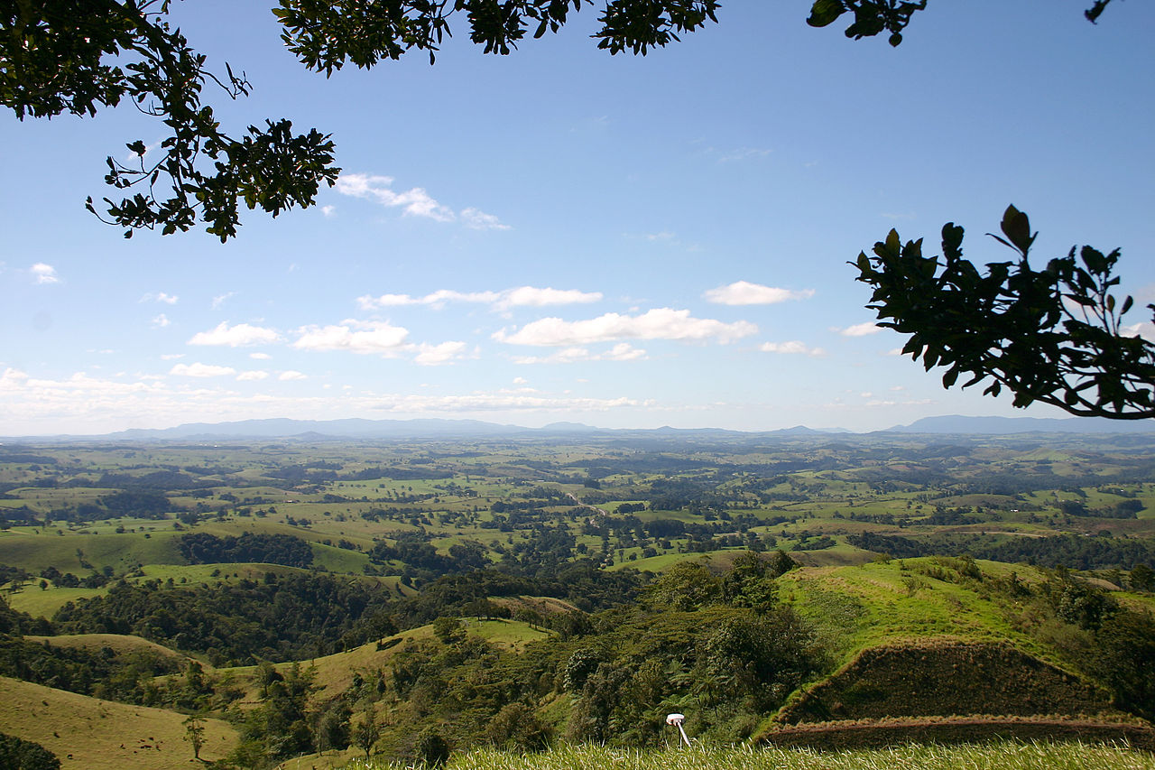
The Atherton Tableland is an elevated plateau in the hinterland of Cairns in Far North Queensland, Australia, rising from the tropical coastal lowlands to an average elevation of 700 to 900 meters. Covering approximately 32,000 square kilometers of undulating terrain, the Tableland is bounded by the dramatic escarpment of the Great Dividing Range to the east, beyond which the land drops steeply to the narrow coastal plain and the Coral Sea.
Introduction
The Tableland's combination of volcanic soils, high rainfall, and moderate temperatures creates an agricultural paradise that is also a center of extraordinary biodiversity. Its landscapes range from ancient Gondwanan rainforest to productive dairy farms, from volcanic crater lakes to towering waterfalls — all within an hour's drive of the Great Barrier Reef coast.
Geography & Geology
- Area: ~32,000 km²
- Elevation: 700-900 m average
- Rock Type: Basalt over granite and metamorphic basement
- Volcanic Activity: Most recent eruptions ~10,000 years ago
The Atherton Tableland sits on a basement of Precambrian metamorphic rocks and granites, overlain by extensive basalt lava flows erupted during the Cenozoic era. The most recent volcanic activity occurred roughly 10,000-17,000 years ago along the Atherton Volcanic Province, one of the youngest volcanic fields in Australia. These eruptions created the Tableland's famous crater lakes, including Lake Eacham and Lake Barrine, both occupying maars (explosion craters).
The eastern escarpment of the Tableland is one of the most dramatic landscape features in Australia. The Barron River plunges over the escarpment at Barron Falls, a 260-meter cascade best seen during the wet season. The Skyrail Rainforest Cableway and the Kuranda Scenic Railway both traverse this escarpment, providing spectacular views of the rainforest canopy and waterfalls. The escarpment receives some of the highest rainfall in Australia, exceeding 8,000 mm annually in some locations.
Climate & Rainfall
- Temperature: 17-28°C (cooler than coast)
- Annual Rainfall: 1,200-8,000 mm (varies dramatically)
- Wet Season: December-April
- Frost: Occasional frost on the western Tableland in winter
The Atherton Tableland's climate is significantly cooler than the sweltering Cairns coast just 60 kilometers to the east. Maximum temperatures average 28°C in summer and 22°C in winter, with overnight minimums occasionally dropping to near freezing on the drier western portions. The elevation and cooler temperatures made the Tableland a favored retreat during the colonial era and continue to attract retirees and tree-changers.
Rainfall varies enormously across the Tableland due to the orographic effect of the Great Dividing Range escarpment. The eastern edge, where moist trade winds are forced upward over the escarpment, receives staggering rainfall — Bellenden Ker, near the escarpment edge, averages over 8,000 mm annually and holds Australia's rainfall records. The western Tableland, in the rain shadow, receives a more modest 1,200-1,500 mm and can experience drought conditions.
Rainforest & Biodiversity
- World Heritage: Wet Tropics of Queensland (listed 1988)
- Forest Age: Gondwanan rainforest lineage, 100+ million years
- Key Species: Musky rat-kangaroo, Lumholtz's tree-kangaroo, cassowary
- Plant Diversity: Over 3,000 species in the Wet Tropics region
The Atherton Tableland's rainforests are part of the Wet Tropics of Queensland World Heritage Area, recognized for containing the most complete and diverse living record of the major stages in the evolution of land plants, from the earliest ferns and conifers to modern flowering plants. These forests are direct descendants of the Gondwanan rainforests that covered Australia millions of years ago and contain primitive plant families found nowhere else.
The Tableland's rainforests harbor a concentration of unique wildlife: the musky rat-kangaroo (the world's smallest kangaroo), Lumholtz's tree-kangaroo, the southern cassowary (a giant flightless bird), and the platypus, which is found in the region's streams. The crater lakes support populations of the endangered Lake Eacham rainbowfish, found only in a few Tableland waterways. Over 3,000 plant species have been recorded in the Wet Tropics region, including 700+ not found anywhere else in the world.
Agriculture & Economy
- Key Products: Sugar cane, dairy, tropical fruits, macadamia nuts, coffee
- Dairy Industry: Major producer for tropical Australia
- Coffee: Established since the 1880s; Skybury is Australia's largest coffee estate
- Tourism: ~2 million visitors annually to the Tablelands region
The deep basalt soils and reliable rainfall make the Atherton Tableland one of the most productive agricultural areas in tropical Australia. The dairy industry, established in the early 1900s, produces milk, cheese, and chocolate for regional markets. Tropical fruits — mangoes, avocados, bananas, lychees, and macadamia nuts — thrive in the volcanic soils. The region is also one of Australia's only coffee-growing areas, with boutique estates producing small-batch specialty coffee.
The contrast between the lush agricultural landscape and the remnant rainforest patches creates a distinctive patchwork seen from the air. Large areas of the original rainforest were cleared for dairy farming in the early 20th century, and the environmental consequences — soil erosion, loss of wildlife corridors, and water quality decline — are now being addressed through revegetation programs. Wildlife corridors connecting isolated rainforest patches are among the Tableland's most important conservation investments.
Key Facts
- The Atherton Tableland covers ~32,000 km² at 700-900 m in Far North Queensland.
- Volcanic crater lakes Eacham and Barrine were formed by eruptions as recently as 10,000 years ago.
- The eastern escarpment receives over 8,000 mm of rainfall annually — among Australia's wettest areas.
- The Tableland's rainforests are part of the Wet Tropics World Heritage Area, listed in 1988.
- The musky rat-kangaroo, found here, is the world's smallest kangaroo species.
Fun Facts
- The Curtain Fig Tree on the Atherton Tableland is a giant strangler fig whose aerial roots form a 15-meter-wide curtain — one of the most photographed trees in Australia.
- Lake Eacham's waters are so clear and pure that it has no inlet or outlet streams — it is fed entirely by rainfall and underground seepage.
- The Atherton Tableland was a major military staging area during World War II, with tens of thousands of Australian and American troops training there before Pacific campaigns.
- Platypuses in the Tableland's streams are among the northernmost populations of this species in the world.
Final Thoughts
The Atherton Tableland is one of Australia's most remarkable landscapes — a tropical highland where ancient Gondwanan rainforests coexist with productive farmland, volcanic craters hold jewel-like lakes, and wildlife found nowhere else on Earth goes about its business in the shadow of 100-million-year-old trees. Its accessibility from Cairns makes it one of the most visited plateaus in the southern hemisphere, yet its ecological significance would warrant attention even in the most remote corner of the planet.
Test Your Knowledge!
Think you know your plateaus and plains? Try our interactive quiz!
Play Geographic Features Quiz →