
Introduction
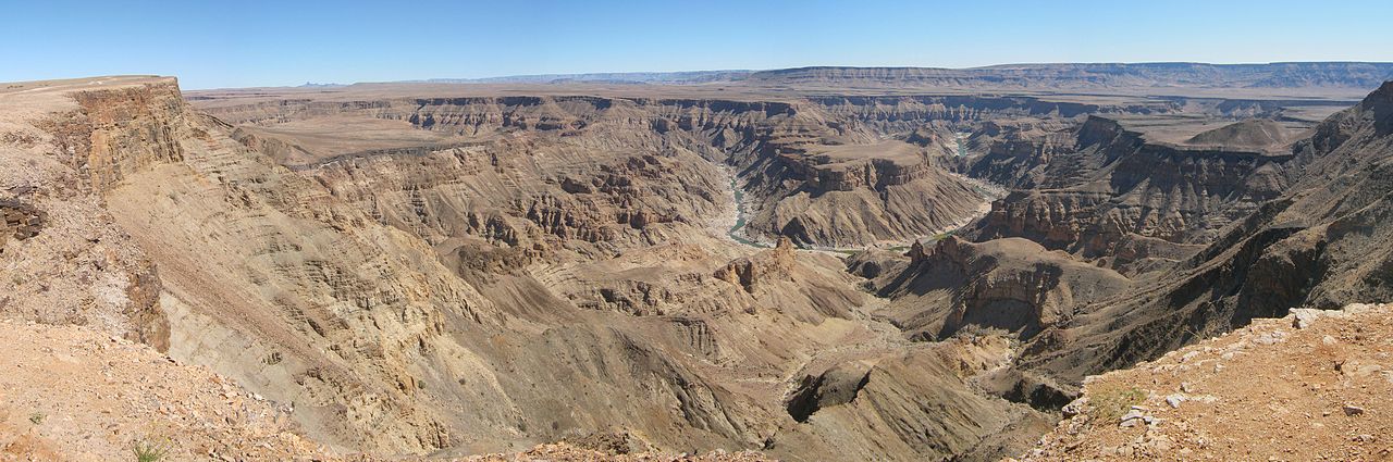
Fish River Canyon in southern Namibia is the largest canyon in Africa and often cited as the second largest in the world after the Grand Canyon. Carved by the Fish River over hundreds of millions of years, the canyon slices through a stark desert landscape, reaching depths of up to 549 meters.
Part of the Ai-Ais/Richtersveld Transfrontier Park, the canyon draws hikers from around the world to tackle the demanding 85-kilometer trail along its floor. The area's extreme aridity, scorching temperatures, and remarkable geological formations make it one of Namibia's most visited natural attractions.
Geology & Formation
- Age of Basement Rock: 1.8 billion years
- Initial Fracturing: 500 million years ago
- Major Erosion Phase: 350-300 million years ago
- Rock Types: Gneiss, granite, quartzite, shale
The canyon's formation began with tectonic fracturing of the Nama Group sedimentary rocks roughly 500 million years ago, creating a graben or rift valley. The Fish River then exploited this weakened zone, carving deeper over hundreds of millions of years through layers of quartzite, shale, and sandstone down to ancient gneiss and granite basement rocks.
A major phase of glacial erosion during the Carboniferous and Permian periods (around 350 to 300 million years ago) significantly deepened the canyon. Evidence of this ice age is visible in glacial striations and tillite deposits along the canyon walls. The canyon's characteristic horseshoe bends were formed as the river meandered across a once-flat plain before uplift accelerated downcutting.
Dimensions & Scale
- Length: 160 km (99 mi)
- Maximum Width: 27 km (17 mi)
- Maximum Depth: 549 m (1,801 ft)
- Inner Canyon Width: Up to 550 m
Fish River Canyon stretches approximately 160 kilometers in length, reaching a maximum width of 27 kilometers and a depth of 549 meters. The canyon has a distinctive double structure: a wider upper canyon and a narrower inner gorge where the river currently flows.
The inner canyon, often just 550 meters wide, contains the actual river channel and is flanked by steep cliffs. The upper portion forms a broader valley with more gradual slopes. This two-tiered structure reflects different phases of erosion and geological faulting over hundreds of millions of years.
Ecosystems & Wildlife
- Climate: Arid, semi-desert
- Annual Rainfall: Less than 100 mm
- Temperature Range: 0°C to 50°C
- Notable Flora: Quiver trees, euphorbias
Despite its extreme aridity, with less than 100 millimeters of rainfall per year, the canyon supports a surprisingly resilient desert ecosystem. Quiver trees (Aloidendron dichotomum), euphorbias, and various succulents cling to the rocky slopes, while tamarisk and wild fig trees grow near permanent water pools along the river.
Wildlife adapted to this harsh environment includes klipspringer antelope, kudu, Hartmann's mountain zebra, baboons, and rock hyraxes. The canyon is also home to leopards, though they are rarely seen. Fish eagles and black eagles patrol the skies, while the river pools contain species of catfish and yellowfish that survive in the intermittent waters.
Cultural History
- Indigenous People: San (Bushmen), Nama, Bondelswarts
- Rock Art Sites: Multiple locations along canyon
- Colonial Period: German South West Africa era
- Conservation Area Since: 1969
The San people inhabited the Fish River Canyon region for thousands of years, leaving rock engravings at various sites along the canyon walls. The Nama and Bondelswarts peoples later settled in the area, using the canyon's seasonal water sources and game for survival in an otherwise unforgiving landscape.
During the German colonial period in the early 1900s, the Bondelswarts were displaced from their traditional lands near the canyon. The area was proclaimed a conservation area in 1969 and later incorporated into the Ai-Ais/Richtersveld Transfrontier Park, a cross-border protected area shared with South Africa.
Notable Viewpoints & Features
- Main Viewpoint: Hobas area (canyon rim)
- Hiking Trail Length: 85 km (53 mi)
- Trail Duration: 4-5 days
- Hot Springs: Ai-Ais (60°C sulfur springs)
The main viewpoint at Hobas, near the northern end of the canyon, offers dramatic panoramic views of the canyon's horseshoe bends. Several additional viewpoints along the rim road provide different perspectives of the canyon's scale and the winding river far below.
The Fish River Canyon Hiking Trail, open only from May to September due to extreme summer heat, runs 85 kilometers from Hobas to Ai-Ais. At the trail's southern terminus, the Ai-Ais Hot Springs resort offers natural sulfur-rich hot springs at 60°C, long used by indigenous peoples for their therapeutic properties. The hike is considered one of Africa's great multi-day treks.
Key Facts
- Fish River Canyon is the largest canyon in Africa at 160 km long and up to 549 m deep.
- The canyon's basement rocks are approximately 1.8 billion years old.
- Its two-tiered structure reflects separate geological processes of faulting and river erosion.
- The 85-kilometer hiking trail is one of the most celebrated multi-day treks in Africa.
- Ai-Ais Hot Springs at the canyon's southern end reach temperatures of 60°C.
Fun Facts
- The Fish River is the longest interior river in Namibia, yet it flows only intermittently during the rainy season.
- Temperatures at the canyon floor can exceed 50°C in summer, which is why the hiking trail closes from October to April.
- The canyon's horseshoe bend rivals the famous Horseshoe Bend of the Colorado River in Arizona.
- Despite its extreme aridity, flash floods can turn the dry riverbed into a raging torrent within hours.
Final Thoughts
Fish River Canyon is a testament to the slow, relentless forces of erosion acting over an almost incomprehensible timescale. From its ancient gneiss foundations to its desert-adapted wildlife and world-class hiking trail, the canyon offers a raw, unhurried encounter with geological time that few places on Earth can match.
