
At a glance
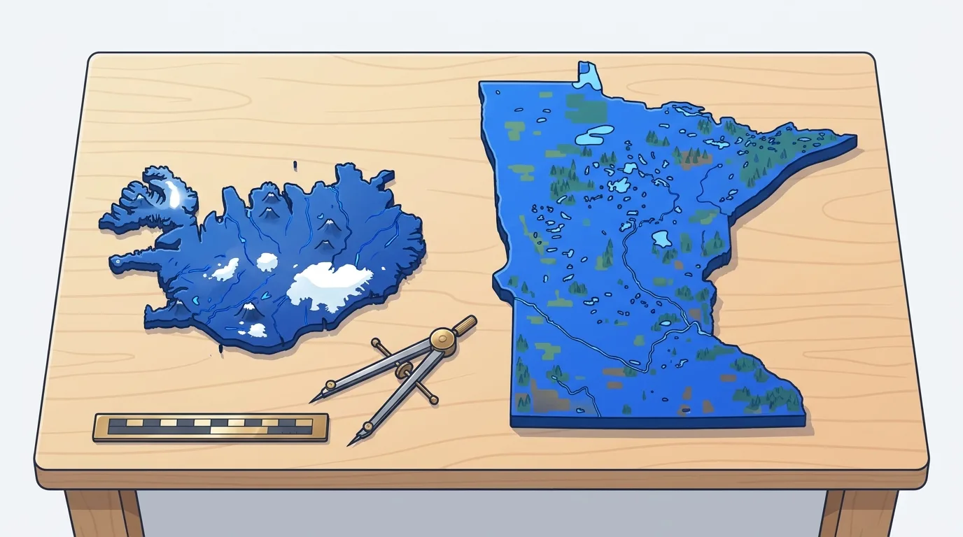
Minnesota is more than twice the size of Iceland, covering 225,163 km² (86,936 sq mi) compared to Iceland's 103,000 km² (39,769 sq mi). Even though flat world maps often make the North Atlantic island look nearly as large as the Upper Midwest, an equal-area view shows a 2.19-to-1 ratio in Minnesota's favor.
Side-by-side metrics highlight how a subarctic volcanic island stacks up against a continental US state across land area, dimensions, elevation, and human settlement.
Minnesota covers 225,163 square kilometers, making it more than twice as large as Iceland at 103,000 square kilometers.
| Metric | Iceland | Minnesota |
|---|---|---|
| Total area | 103,000 km² (39,769 sq mi) | 225,163 km² (86,936 sq mi) |
| Land area | 100,250 km² (38,707 sq mi) | 206,232 km² (79,627 sq mi) |
| Water area | 2,750 km² (1,062 sq mi) | 18,930 km² (7,309 sq mi) |
| North-to-south length | 300 km (186 mi) | 653 km (406 mi) |
| East-to-west width | 500 km (311 mi) | 560 km (348 mi) |
| Population | ~390,000 | ~5.7 million |
| Population density | 3.8 per km² (9.8 per sq mi) | 27.6 per km² (71.5 per sq mi) |
| Highest elevation | Hvannadalshnúkur, 2,110 m (6,923 ft) | Eagle Mountain, 701 m (2,301 ft) |
How big is Iceland compared to Minnesota in total area?
When placed on an equal-area map, Minnesota covers 225,163 km² (86,936 sq mi), while Iceland covers 103,000 km² (39,769 sq mi). You could fit two complete Icelands (206,000 km²) inside the borders of Minnesota and still have 19,163 km² (7,399 sq mi) of leftover room across the state.
Because it lies so far north, standard cylindrical world maps stretch its outline horizontally and vertically, making it appear comparable to large mid-latitude states.
Even if you subtract Minnesota's 18,930 km² of inland water and Lake Superior jurisdiction, its dry land area of 206,232 km² is still double Iceland's total footprint.
Three cartographic factors explain why Iceland looks deceptively large on standard wall and web maps:
- High-latitude stretching: Cylindrical projections like Web Mercator inflate area by the secant squared of latitude, stretching Iceland at 65° N roughly 2.7 times more in linear scale than Minnesota at 46° N.
- Isolation in open ocean: Sitting alone in the North Atlantic without bordering states or countries makes the island stand out visually.
- Indented fjord coastlines: Deep bays and rugged peninsulas, particularly in the Westfjords, give the island a 500 km by 300 km bounding box despite deep sea cutouts.
Iceland: 103,000 square kilometers of volcanoes, glaciers, and fjords
Iceland owes its 103,000 km² landmass and dramatic vertical relief to its position straddling the Mid-Atlantic Ridge, where the North American and Eurasian tectonic plates pull apart at about 2 cm per year. Unlike the ancient continental shield of the American Midwest, Iceland is geologically young, formed over the last 16 to 18 million years by rift-zone eruptions and a deep mantle hotspot.
Vatnajökull is Europe's largest glacier in Iceland, covering roughly 7,700 km² of the southeastern highlands and hiding active subglacial calderas beneath ice up to 950 m thick. On the southern rim of Vatnajökull rises Hvannadalshnúkur on Öræfajökull, the island's highest peak at 2,110 m (6,923 ft), while Eyjafjallajökull stands nearby as a 1,651 m glacier-capped volcano.
Within this compact island footprint, Iceland packs around 30 active volcanic systems into an area less than half the size of Minnesota.
The island divides naturally into four distinct physical zones:
- The Interior Highlands (Miðhálendið): Over 40,000 km² of uninhabited volcanic desert, black basalt sand, and lava plateaus above 400–500 m elevation.
- Glaciers and Outwash Plains (Sandur): Massive ice sheets like Vatnajökull, Langjökull, and Hofsjökull that feed braided meltwater rivers and broad coastal sand plains.
- The Fjord Coastlines: Deep, glacier-carved inlets in the Westfjords and Eastfjords, contributing to a 4,970 km (3,088 mi) marine coastline.
- Geothermal Lowlands: Active rift valleys in the southwest and north hosting steaming vents, waterfalls like Gullfoss, and Geysir, the hot spring that named all geysers.
Minnesota: 225,163 square kilometers of glacial lakes, woods, and prairie
Where Iceland is built by young volcanic fire and active ice caps, Minnesota's 225,163 km² footprint was sculpted by the Laurentide Ice Sheet, which retreated roughly 10,000 to 12,000 years ago. Those continental glaciers scraped across ancient Precambrian Canadian Shield bedrock in the northeast and deposited thick blankets of fertile glacial till across the south and west.
Liquid water defines Minnesota's surface on a scale larger than Iceland's glaciers. Minnesota's highest point, Eagle Mountain in the northern Misquah Hills, reaches 701 m (2,301 ft), exactly one-third the height of Iceland's Hvannadalshnúkur.
Because the state sits at the continental crossroads of three major North American biomes and three continental watersheds (Hudson Bay, the Great Lakes, and the Mississippi River), its terrain shifts across four primary regions:
- The Arrowhead and Laurentian Mixed Forest: Exposed volcanic and granite bedrock, boreal pine and birch woods, and over 1,000 interconnected canoe lakes along the Canadian border.
- The Central Hardwood and Lake District: Rolling glacial moraines and thousands of kettle lakes formed where buried blocks of ice melted in place.
- The Driftless Area and Mississippi Blufflands: Deep limestone valleys in the southeast that escaped the most recent glaciation, carved by the upper Mississippi River.
- The Western and Southern Tallgrass Prairies: Flat agricultural plains and the pancake-flat Red River Valley, which once formed the lakebed of prehistoric Glacial Lake Agassiz.
Driving distances, coastlines, and how big each place feels on the road
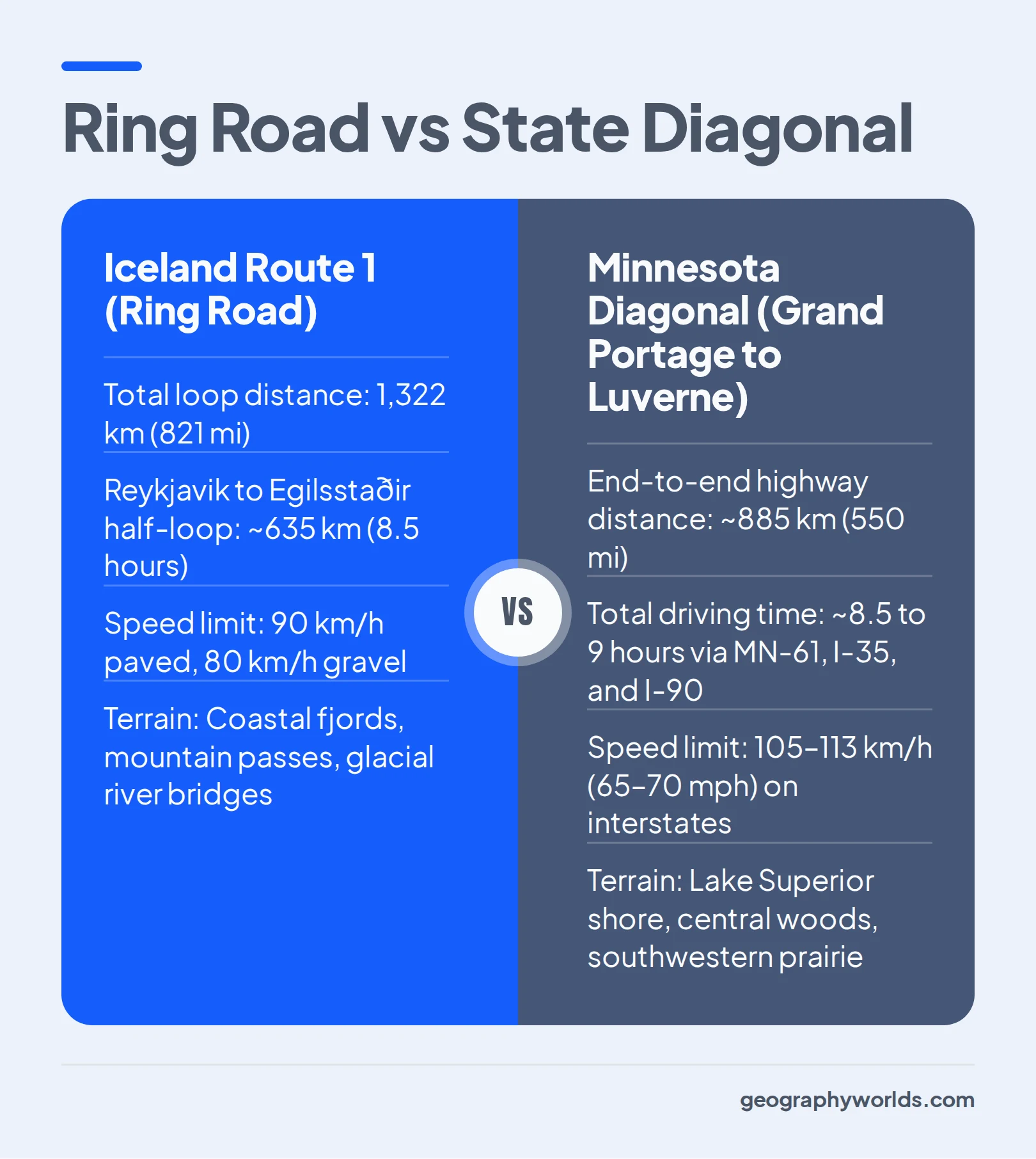
Size on a map does not always match how big a place feels behind the steering wheel. Although Minnesota has more than double the land area, driving a full loop around Iceland covers a longer road distance than driving across Minnesota from corner to corner.
In Iceland, the uninhabited central highlands and glaciers force cross-country traffic onto Route 1, the Ring Road, which forms a 1,322 km (821 mi) loop around the island's perimeter.
Driving from Reykjavik in the southwest to Egilsstaðir in the east covers about 635 km (395 mi) on Route 1 and takes roughly 8 to 9 hours without stops because the two-lane highway speed limit caps at 90 km/h (56 mph) on pavement and 80 km/h (50 mph) on gravel.
Minnesota's highway network cuts straight through the state's interior on high-speed multi-lane interstates with speed limits of 105–113 km/h (65–70 mph). A diagonal drive from Grand Portage on the Canadian border in the northeast (via MN-61, I-35, and I-90) to Luverne in the far southwest corner covers roughly 885 km (550 mi) and takes about 8.5 to 9 hours of continuous driving.
Tip: When estimating driving times in Iceland, remember that coastal fjords can double or triple road distance compared to straight-line distance, especially in the Westfjords where tracing the shoreline adds hundreds of kilometers outside the 1,322 km Ring Road.
How road geometry and coastlines shape travel in each territory:
- Perimeter loop vs. interior grid: Iceland's 1,322 km Ring Road circles impassable central ice caps, while Minnesota's over 220,000 km of public roads cross the entire state in a direct compass grid.
- Coastline tracing: Iceland's 4,970 km coastline forces drivers around deep sea inlets, whereas Minnesota's 304 km (189 mi) Lake Superior North Shore offers a straight scenic run on Highway 61.
- Winter road access: Minnesota maintains its interstate and state highway grid year-round, while Iceland's interior F-roads (mountain tracks) close completely from September to June.
Population, cities, and empty space: Reykjavik against the Twin Cities
The demographic gap between the two places is far wider than the territory gap. Iceland's population of roughly 390,000 yields a national density of just 3.8 residents per km² (9.8 per sq mi), making it the most sparsely populated country in Europe.
Even though the Twin Cities metro holds nearly 15 times as many people as Greater Reykjavik, both territories concentrate almost two-thirds of their entire population into a single primary urban hub.
Outside the primary metro hub, however, their settlement maps diverge sharply:
- Secondary cities: Iceland's largest town outside the southwest, Akureyri in the north, has only about 20,000 residents, whereas Minnesota supports regional cities like Rochester (~122,000), Duluth (~87,000), St. Cloud (~70,000), and Mankato (~45,000).
- Uninhabited wilderness: Over 40,000 km² of Iceland's central highlands have a permanent population of zero, compared to Minnesota's largest roadless reserve, the 4,400 km² (1.09 million acre) Boundary Waters Canoe Area Wilderness.
- Rural distribution: Southern and western Minnesota are blanketed by farmsteads and county seats every 15 to 30 km, while rural Iceland consists of isolated sheep and horse farms strung along narrow coastal strips and river valleys.
Latitude and climate: Why northern Minnesota freezes harder than coastal Iceland
A glance at latitude numbers suggests that Iceland should be dramatically colder than Minnesota. Reykjavik sits at 64°08′ N, roughly 2,100 km (1,300 mi) farther north than Minneapolis at 44°59′ N, placing Iceland's capital at the same latitude as Fairbanks, Alaska, and Nome. Yet midwinter temperatures in Minnesota plunge far below the winter averages of coastal Iceland.
In Reykjavik, the average January temperature hovers near −0.5°C to 0°C (31°F to 32°F), and coastal lows rarely drop below −10°C (14°F).
Minnesota experiences severe continentality near the geographic center of North America, more than 1,600 km from warm ocean currents.
In Minneapolis, the average January daily mean is around −9°C (16°F), while International Falls on the northern border averages −15°C (5°F) in January with an average low near −21°C (−6°F) and historical extremes down to −48°C (−55°F). Conversely, Minneapolis summers reach an average July high of 29°C (84°F), whereas Reykjavik's July highs average a cool 14°C (57°F).
Watch out: Milder winter thermometer readings in Iceland do not mean easy weather; fierce North Atlantic low-pressure gales, rapid freeze-thaw icing, and horizontal sleet close mountain roads even when temperatures sit near 0°C.
If you enjoy testing how latitude, ocean currents, and map distortion shape places around the world, Geography Worlds offers over 30 free interactive online geography games, including Climate Clue and Country Shapes Identification, right in your web browser alongside articles on the Geography Worlds blog.
Which to choose
Whether you are using these two territories as a mental yardstick for map scale or comparing them for travel and study, each stands out for specific geographic reasons:
- For visualizing true map scale: Use Minnesota (225,163 km²) as a reference frame that holds more than two full Icelands (103,000 km² each), correcting the polar distortion of Mercator maps.
- For dramatic tectonic and glacial relief: Choose Iceland, where 2,110 m volcanic peaks, 11,400 km² of glaciers, and deep marine fjords sit within a single 1,322 km coastal loop.
- For vast freshwater networks and continental seasons: Choose Minnesota, where 11,842 glacial lakes, boreal canoe wilderness, and 29°C summer highs stretch across a state twice the island's size.
- For studying climate geography: Pair Reykjavik (64° N) and Minneapolis (45° N) to demonstrate how maritime currents vs. continental interiors override a 19-degree difference in latitude.
Test Your Map Scale Skills!
Can you identify countries by their outline and climate? Play over 30 free geography games in your browser.
Play Geography Games →