
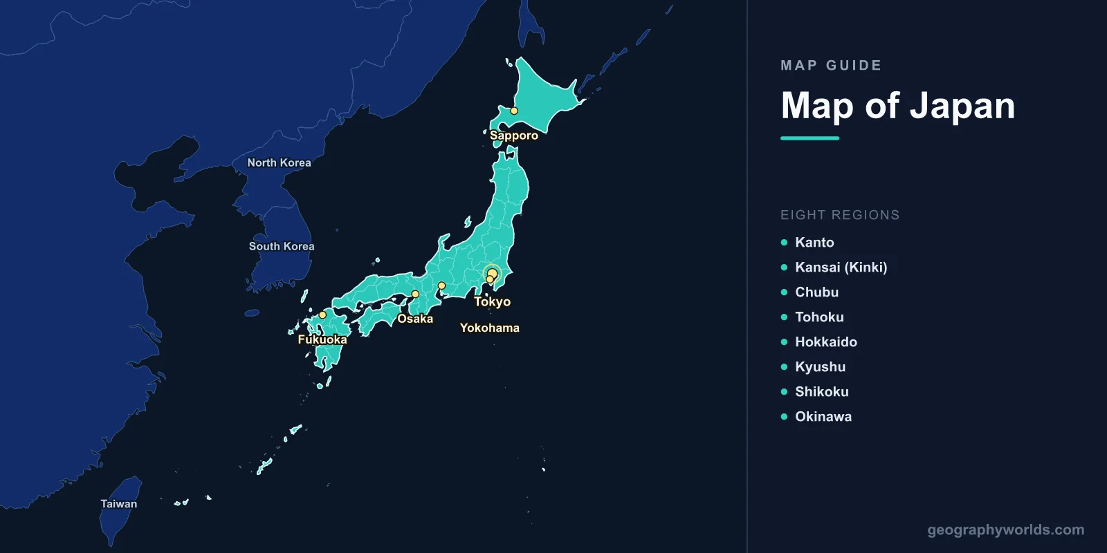
Japan is an island nation in East Asia, consisting of 6,852 islands covering 377,975 km2 (145,937 sq mi) with a population of approximately 123.3 million. The capital is Tokyo (35.6762°N, 139.6503°E). A map of Japan shows four main islands—Honshu, Hokkaido, Kyushu, and Shikoku—plus the Ryukyu island chain stretching southwest toward Taiwan. The country is divided into 47 prefectures and 8 traditional regions.
Introduction
Japan lies along the Pacific Ring of Fire at the junction of four tectonic plates, making it one of the most seismically active countries on Earth. The Japanese archipelago stretches 3,000 km from northeast to southwest, spanning subarctic to subtropical climates. About 73% of the country is mountainous, with the Japanese Alps and numerous volcanoes dominating the interior.

Geographic Overview
- Area: 377,975 km2 (145,937 sq mi)
- Population: 123.3 million (2024)
- Capital: Tokyo
- Coordinates: 36.2048°N, 138.2529°E
- Highest Point: Mount Fuji, 3,776 m
- Coastline: 29,751 km
- Islands: 6,852 total; 4 main islands
Japan’s terrain is about 73% mountainous, leaving only 27% habitable. The Japanese Alps on Honshu include peaks over 3,000 m. The country has 111 active volcanoes, including the iconic Mount Fuji. Flat land is concentrated in coastal plains and river deltas, where most of the population is densely concentrated. Japan sits at the convergence of the Pacific, Philippine Sea, Eurasian, and North American tectonic plates.
Major Regions
- Kanto: Tokyo, Yokohama; 43 million; Japan’s economic center; Kanto Plain
- Kansai (Kinki): Osaka, Kyoto, Kobe; 22 million; cultural heartland
- Chubu: Nagoya; Japanese Alps; Mount Fuji; central Honshu
- Tohoku: Northern Honshu; rural; mountainous; cold winters
- Hokkaido: Northernmost main island; Sapporo; subarctic climate; agriculture
- Kyushu: Southwestern island; Fukuoka; volcanoes; hot springs
- Shikoku: Smallest main island; 88 Temple Pilgrimage; mountainous interior
- Okinawa: Subtropical Ryukyu islands; 1,600 km southwest of Tokyo
Japan’s eight traditional regions reflect climatic and cultural differences shaped by the mountainous terrain. The Pacific side of Honshu (Kanto, Kansai) is the most urbanized. The Sea of Japan side (Hokuriku, San’in) receives heavy snowfall from moisture-laden winds crossing the sea. Okinawa’s subtropical climate and Ryukyuan cultural heritage set it apart from mainland Japan.
Major Cities
- Tokyo: 14 million (city), 37 million (metro); world’s largest metropolitan area
- Yokohama: 3.7 million; Tokyo Bay; Japan’s second-largest city
- Osaka: 2.7 million; Kansai region; commercial hub
- Nagoya: 2.3 million; Chubu region; automotive industry (Toyota)
- Sapporo: 2.0 million; Hokkaido’s capital; winter sports hub
- Fukuoka: 1.6 million; northern Kyushu; gateway to South Korea and China
The Tokyo-Yokohama metropolitan area is the largest in the world by population, housing about 30% of Japan’s entire population on less than 4% of its land. The Tokaido Shinkansen corridor connecting Tokyo, Nagoya, and Osaka is one of the busiest transportation corridors on Earth. Sapporo’s cold climate made it the host of the 1972 Winter Olympics, and it receives an average of nearly 5 meters of snowfall annually.
Bodies of Water & Natural Features
- Mount Fuji: 3,776 m; Japan’s highest and most iconic peak; UNESCO World Heritage
- Japanese Alps: Three mountain ranges on Honshu; peaks over 3,000 m
- Shinano River: 367 km; Japan’s longest river; Niigata Prefecture
- Lake Biwa: 670 km2; Japan’s largest lake; Shiga Prefecture; 4 million years old
- Seto Inland Sea: 9,500 km2; between Honshu, Shikoku, and Kyushu; over 700 islands
- Pacific Ocean: Eastern coastline; deep trenches; Japan Trench reaches 8,000 m
Japan’s rivers are short and swift due to the mountainous terrain, making them prone to flooding but valuable for hydroelectric power. Lake Biwa is one of the oldest lakes in the world, home to endemic species found nowhere else. The Seto Inland Sea is a sheltered body of water with a mild climate, dotted with hundreds of small islands. Japan’s hot springs (onsen), numbering over 27,000, are a direct result of volcanic activity.
Neighboring Countries
- South Korea: Closest neighbor; 200 km across the Korea Strait
- China: Across the East China Sea; ~800 km to Shanghai
- Russia: Sakhalin and Kuril Islands lie north of Hokkaido
- Taiwan: Ryukyu chain extends toward Taiwan; ~700 km from Okinawa
- North Korea: Across the Sea of Japan; ~900 km from Tokyo
Japan’s island geography has profoundly shaped its culture and history, providing natural isolation while positioning it as a maritime power. The Korea Strait and Tsushima Strait separate Japan from the Asian mainland. Japan’s Exclusive Economic Zone is the sixth-largest in the world at 4.47 million km2, extending far into the Pacific.
Key Facts
- Japan consists of 6,852 islands, with 73% of the land mountainous.
- The Tokyo metro area (37 million) is the world’s most populous metropolitan area.
- Japan has 111 active volcanoes along the Pacific Ring of Fire.
- Mount Fuji (3,776 m) last erupted in 1707 and is a UNESCO World Heritage Site.
- Japan’s coastline of 29,751 km is longer than Australia’s.
Fun Facts
- Japan’s city of Tokamachi in Niigata receives an average of 11.8 m of snow per year, among the heaviest snowfall of any inhabited area on Earth.
- Lake Biwa is approximately 4 million years old, one of only about 20 ancient lakes in the world.
- The Akashi Kaikyo Bridge connecting Honshu and Awaji Island is the world’s longest suspension bridge at 3,911 m.
- Japan has more vending machines per capita than any country—about 1 machine for every 23 people.
Final Thoughts
Japan’s map reveals an extraordinary archipelago stretching across 3,000 km of latitude, from subarctic Hokkaido to subtropical Okinawa. Its mountainous terrain, volcanic activity, and island geography have created one of the world’s most densely populated and tectonically dynamic nations. Understanding Japan’s 47 prefectures, four main islands, and natural features is key to appreciating its unique place in world geography.
Test Your Geography Knowledge!
Think you know your maps? Try our interactive geography games!
Play Geography Games →