

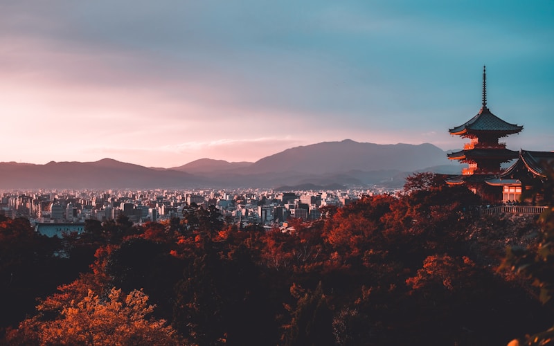
Kyoto, the former imperial capital of Japan and home to roughly 1.5 million people, lies in a broad basin on the island of Honshu, ringed by mountains on three sides. Founded in 794 AD, the city preserves an ancient grid plan and some 1,600 Buddhist temples, its geography as carefully composed as its gardens.
Introduction
For more than a thousand years, from 794 until 1868, Kyoto was the seat of Japan's emperor and the cultural heart of the nation. Its founders chose the site with great care, following Chinese principles of geomancy that favored a location enclosed by mountains and watered by rivers. The result is a city cradled in a natural bowl, sheltered from the north yet open to the south.
This basin setting has profoundly shaped Kyoto's character. The encircling mountains define its skyline, funnel its rivers and trap its summer heat, while the flat valley floor allowed the founders to lay out a precise checkerboard of streets modeled on the Chinese capital of Chang'an. Understanding Kyoto's physical geography is key to understanding why the city looks and feels the way it does.
Location & Setting
- Coordinates: 35.01°N, 135.77°E
- Region: Kansai region, western Honshu, Japan
- Setting: Kyoto Basin, enclosed by mountains on three sides
- City population: Around 1.5 million
Kyoto lies in the Kansai region of western Japan, inland from Osaka and the sea, at the northern end of the Kyoto Basin. The city occupies the flat floor of this basin, which is bounded by the Tamba Highlands and other ranges to the north, east and west, leaving it open only to the south where the valley broadens toward Osaka Bay. This near-enclosure gives Kyoto a strong sense of being held within its landscape.
The mountains that surround the city, including Higashiyama in the east and Arashiyama in the west, are not high but they press close to the urban edge, and many of Kyoto's most famous temples are built into their forested lower slopes. The basin position, well watered and defensible, was chosen deliberately when Emperor Kanmu moved the capital here in 794.
Physical Geography
- Main river: Kamo River, flowing north to south through the city
- Other rivers: Katsura and Uji, joining to form the Yodo
- Surrounding ranges: Higashiyama, Kitayama and Nishiyama
- Basin floor: Flat alluvial plain built by river sediment
The Kamo River is Kyoto's central waterway, flowing from the northern mountains down through the eastern side of the city. Its tree-lined banks are among the most beloved public spaces in Kyoto, and its course helped orient the ancient street grid. To the west runs the Katsura River, and to the south the Uji, and together these rivers eventually merge to form the Yodo River, which drains the whole basin toward Osaka Bay.
The flat floor of the Kyoto Basin is an alluvial plain built up over thousands of years by sediment washed down from the surrounding mountains. This level, well-drained ground made it possible to lay out the city's famous rectangular grid, while the encircling ranges of Higashiyama, Kitayama and Nishiyama, the eastern, northern and western mountains, provide a constant scenic backdrop and abundant groundwater that has long sustained Kyoto's sake brewing and tea culture.
Climate
- Climate type: Humid subtropical (Köppen Cfa)
- Summer temps: 30–35°C, hot and very humid
- Winter temps: 1–9°C, occasional snow
- Annual rainfall: ~1,500 mm
Kyoto has a humid subtropical climate made more extreme by its basin location. Because the surrounding mountains trap warm, moist air and block cooling breezes, summers are notoriously hot and sticky, with temperatures regularly reaching the mid-thirties Celsius and high humidity that lingers well into the night. Kyoto's summer heat is famous throughout Japan for being especially oppressive.
Winters, by contrast, are cold for a city at this latitude, with temperatures often dropping close to freezing and occasional snowfalls that dust the temples and gardens beautifully. The city has four sharply defined seasons that are central to its culture, from the cherry blossoms of spring to the vivid autumn foliage on the mountainsides. The rainy season in June and July and the typhoon season in late summer bring the bulk of the roughly 1,500 millimeters of annual rain.
Districts & Layout
- Grid plan: Chessboard streets modeled on Chang'an, from 794 AD
- Historic core: Imperial Palace and central wards
- Temple zones: Higashiyama and Arashiyama foothills
Kyoto's street layout is one of the most striking examples of planned urban geography in the world. When the capital, then called Heian-kyo, was founded in 794, its designers laid out a precise rectangular grid of north-south and east-west streets copied from the Chinese Tang dynasty capital of Chang'an. Much of this ancient grid survives today, making central Kyoto exceptionally easy to navigate compared with most Japanese cities.
The city center, on the basin floor, holds the former Imperial Palace, the commercial districts and the geisha quarters such as Gion. Radiating outward, the most treasured historic areas climb the surrounding foothills: the temple-lined slopes of Higashiyama in the east, and the bamboo groves and hillsides of Arashiyama in the west. In all, Kyoto contains around 1,600 Buddhist temples and hundreds of Shinto shrines, many protected as UNESCO World Heritage Sites.
Population & Growth
- City population: Around 1.5 million
- Status: Capital of Kyoto Prefecture, Kansai region
- Constraint: Growth limited by the surrounding mountains
Kyoto is home to around 1.5 million people, making it one of Japan's largest cities and a major node in the Osaka-Kobe-Kyoto metropolitan region. Having lost its status as national capital to Tokyo in 1868, Kyoto reinvented itself as a center of culture, education, tourism and high-technology manufacturing, with globally known companies rooted in the city.
The encircling mountains that give Kyoto its beauty also constrain its expansion, confining the built-up area largely to the basin floor. Strict height limits and preservation rules, designed to protect views of the temples and mountains, further shape the city's low-rise skyline. As a result Kyoto has grown more slowly and densely than sprawling Tokyo or Osaka, and its population has edged downward in recent years.
Environmental Challenges
- Summer heat: Intensified by the enclosed basin and urban heat island
- Flooding: Rivers prone to swelling during heavy rain and typhoons
- Overtourism: Pressure on historic districts and transport
Kyoto's basin geography intensifies its environmental pressures. The bowl-like setting traps heat and pollutants, worsening the already fierce summer temperatures through the urban heat island effect and making heatstroke a genuine public-health concern. At the other extreme, the same mountains that ring the city channel heavy rainfall into the Kamo and other rivers, which can rise rapidly and threaten flooding during the rainy season and typhoons.
In recent years Kyoto has also grappled with the strains of overtourism, as millions of visitors crowd its narrow historic lanes, temples and public transport, straining infrastructure and local life. The city continues to balance the preservation of its irreplaceable cultural landscape and mountain setting against the demands of a modern population and a huge tourist economy.
Quick Questions
Why is Kyoto surrounded by mountains?
Kyoto sits in the Kyoto Basin, a natural bowl enclosed by mountains on its northern, eastern and western sides and open only to the south. The site was chosen in 794 AD partly because this sheltered, well-watered setting followed Chinese geomantic ideals for a capital.
What river flows through Kyoto?
The Kamo River runs north to south through the eastern part of the city and is Kyoto's central waterway. Along with the Katsura and Uji rivers it drains the basin, and together they merge to form the Yodo River flowing toward Osaka Bay.
How old is Kyoto's grid layout?
Kyoto's rectangular street grid dates from 794 AD, when the city, then called Heian-kyo, was laid out as the imperial capital on the model of the Chinese Tang capital Chang'an. Much of that ancient grid is still in use today.
Key Facts
- Kyoto lies in a basin ringed by mountains on three sides in western Japan.
- It is home to around 1.5 million people and was Japan's capital from 794 to 1868.
- The Kamo River flows through the city, which contains some 1,600 Buddhist temples.
- Its grid street plan, laid out in 794 AD, was modeled on the Chinese capital Chang'an.
- The enclosing mountains trap heat, giving Kyoto famously hot, humid summers.
Test Your Knowledge!
Think you know world city geography? Test your knowledge with our interactive games!
Play Geography Games →