
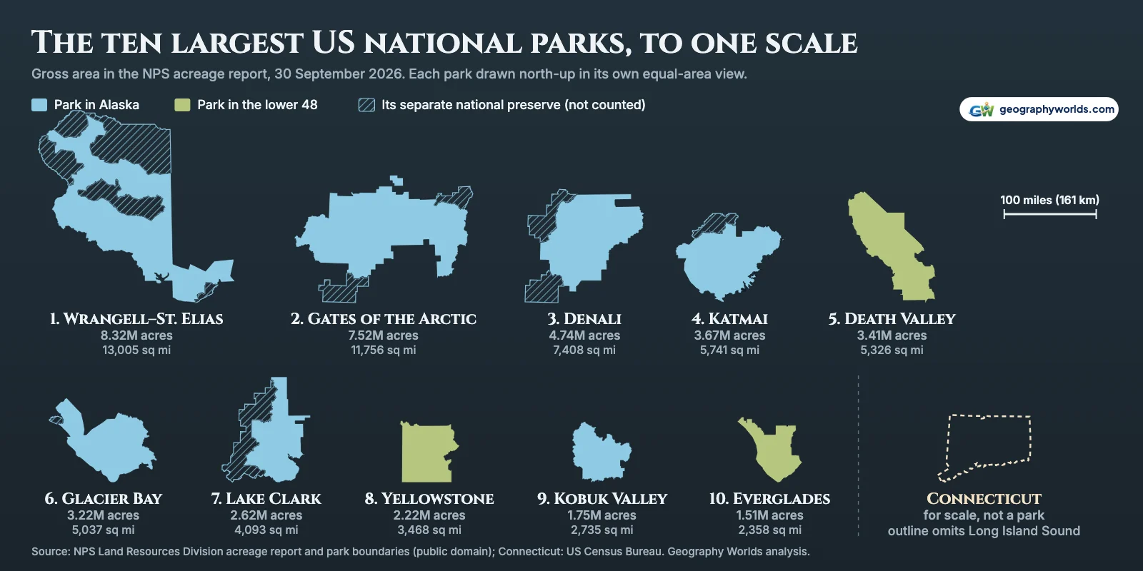
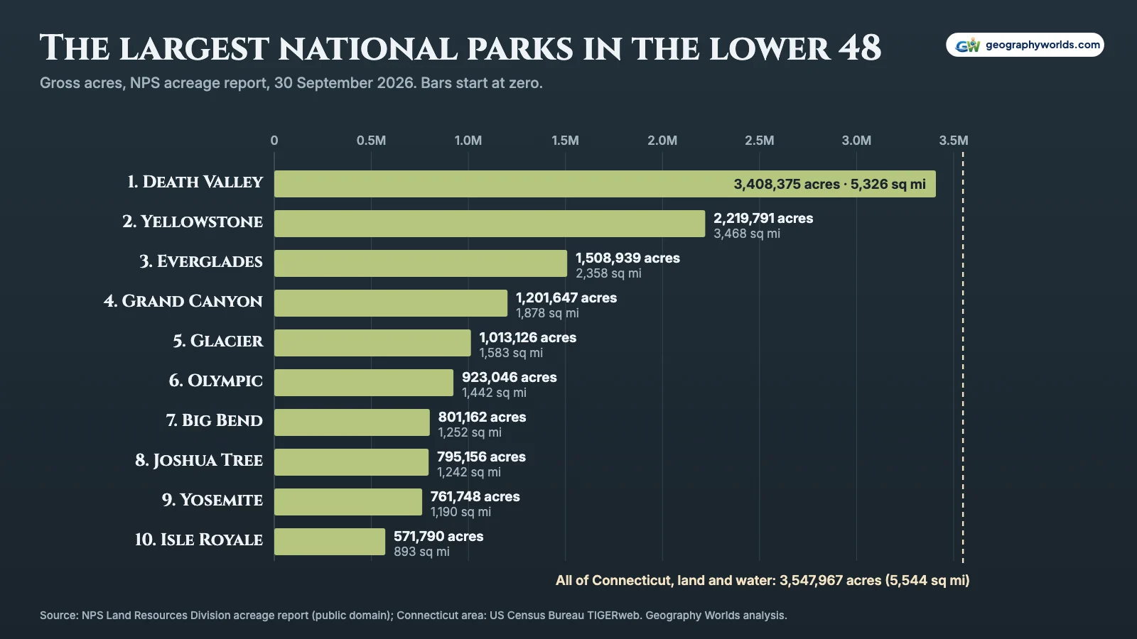
The largest national park in the US is Wrangell–St. Elias in Alaska, at 8,323,146 acres (13,005 square miles, 33,683 km²), followed by Gates of the Arctic (7.52 million acres), Denali (4.74 million), Katmai (3.67 million), Death Valley (3.41 million), Glacier Bay (3.22 million), Lake Clark (2.62 million), Yellowstone (2.22 million), Kobuk Valley (1.75 million) and Everglades (1.51 million). Those are gross areas from the National Park Service’s acreage report for the quarter ending 30 September 2026, the latest available, and they count each national park alone, without the separately listed national preserve that several Alaskan parks have next door. In the lower 48 the order is Death Valley, Yellowstone, Everglades, Grand Canyon (1.20 million), Glacier (1.01 million), Olympic (923,046 acres), Big Bend (801,162), Joshua Tree (795,156), Yosemite (761,748) and Isle Royale (571,790). Seven of the ten largest parks overall are in Alaska.
How big is 13,005 square miles?
The hero image above draws the ten largest parks at one equal-area scale, with Connecticut beside them. Because park areas include the water inside their boundaries, the fair comparison is with a state’s land and water together: Wrangell–St. Elias National Park covers 2.3 times all of Connecticut (5,544 square miles). It is larger than nine states: Maryland, Hawaii, Massachusetts, Vermont, New Hampshire, New Jersey, Connecticut, Delaware and Rhode Island. Maryland, the biggest of those, has 12,406 square miles counting its water. West Virginia, the next state up at 24,230 square miles, stays ahead even if Wrangell–St. Elias’s preserve is added, which brings the total to 20,587 square miles.

The park service’s own comparison uses the combined figure. Its Wrangell–St. Elias home page says that at 13.2 million acres the park is the size of Yellowstone, Yosemite and Switzerland put together. The 13.2 million is park plus preserve: 8,323,146 acres of national park and 4,852,645 acres of national preserve, 13,175,791 in all on the current report.
Only four parks are bigger than all of Connecticut, and all four are in Alaska. Glacier Bay (5,037 square miles) and Death Valley (5,326 square miles, across California and Nevada) are bigger than Connecticut’s 4,843 square miles of land but not the whole state, whose water lies mostly in Long Island Sound; Death Valley falls 218 square miles short, which is why the park described itself in 2019 as “nearly the size of Connecticut”. Our guide to Death Valley National Park covers what all that desert holds.
Further down, the comparisons shrink to smaller states. Yellowstone’s 3,468 square miles are 2.2 times Rhode Island’s 1,545 (land and water), but well short of Connecticut, a match-up we take apart in is Connecticut bigger than Yellowstone? In all, 12 national parks are bigger than the whole of Rhode Island.
Gross acres, federal acres and the preserve next door
The acreage report gives each unit several totals. Gross area is everything inside the park’s authorized boundary: land the park service owns, land other federal agencies own, state land and water, and private inholdings. Federal acres keeps only land the park service owns outright, land where it holds a lesser interest such as an easement, and land owned by other federal agencies. This ranking uses gross area because that is what the park is: the line on the map. Switching to federal acres leaves the first 13 places unchanged; the first swap comes at 14th, where Joshua Tree passes Big Bend.
The gap between the two measures can be wide. Channel Islands in California has 249,561 gross acres but only 79,019 federal ones, 32%: 124,554 acres are listed as other public land and 45,988 as private. National Park of American Samoa has no federal acres at all, because its land belongs to local villages and is leased to the park service for 50 years.
The preserves are the larger complication. Seven national parks share their name with a national preserve that the report lists as a separate unit: Denali, Gates of the Arctic, Glacier Bay, Great Sand Dunes, Katmai, Lake Clark and Wrangell–St. Elias. Those preserves add 9.1 million acres. The report and the boundary file treat each preserve as a unit of its own, so they are not counted here. Counting them would reshuffle the top ten. Wrangell–St. Elias would reach 13.18 million acres and Gates of the Arctic 8.47 million; Lake Clark, with a 1,410,294-acre preserve, would rise above Death Valley, while Glacier Bay, whose preserve is only 58,406 acres, would fall below it. Wrangell–St. Elias’s preserve on its own (4,852,645 acres) would rank 3rd on this list.
Two parks need a note of their own. New River Gorge in West Virginia is a single unit called a national park and preserve, and the report gives one figure for both, 72,405 acres. Most of that is preserve: when it was designated in 2020, its sponsoring senators described the national park as four areas totaling approximately 7,021 acres, with the remaining 90% left as preserve open to hunting. On the rule used for every other park, we rank only the park part, about 7,021 acres, which puts it 61st; the combined unit would be 45th. The report has no ownership split for the park part, so it has no federal figure, and the report’s own summary sheet files the whole unit with the preserves, outside its 52.45 million-acre total for national parks. Everglades includes 108,399 acres listed as the Everglades Expansion, as a footnote in the report instructs; without them it has 1,400,540 acres and is still tenth.
| Rank | National park | State(s) | Gross acres | Sq mi | Federal acres | Same-name preserve, acres (not counted) |
|---|---|---|---|---|---|---|
| 1 | Wrangell–St. Elias | Alaska | 8,323,146 | 13,005 | 7,956,730 | 4,852,645 |
| 2 | Gates of the Arctic | Alaska | 7,523,897 | 11,756 | 7,359,810 | 948,608 |
| 3 | Denali | Alaska | 4,740,911 | 7,408 | 4,732,660 | 1,334,118 |
| 4 | Katmai | Alaska | 3,674,529 | 5,741 | 3,611,564 | 418,699 |
| 5 | Death Valley | California, Nevada | 3,408,375 | 5,326 | 3,355,172 | |
| 6 | Glacier Bay | Alaska | 3,223,383 | 5,037 | 3,222,435 | 58,406 |
| 7 | Lake Clark | Alaska | 2,619,816 | 4,093 | 2,481,441 | 1,410,294 |
| 8 | Yellowstone | Idaho, Montana, Wyoming | 2,219,791 | 3,468 | 2,219,789 | |
| 9 | Kobuk Valley | Alaska | 1,750,716 | 2,735 | 1,714,758 | |
| 10 | Everglades† | Florida | 1,508,939 | 2,358 | 1,508,653 | |
| 11 | Grand Canyon | Arizona | 1,201,647 | 1,878 | 1,180,651 | |
| 12 | Glacier | Montana | 1,013,126 | 1,583 | 1,012,898 | |
| 13 | Olympic | Washington | 923,046 | 1,442 | 913,632 | |
| 14 | Big Bend | Texas | 801,162 | 1,252 | 775,273 | |
| 15 | Joshua Tree | California | 795,156 | 1,242 | 781,989 | |
| 16 | Yosemite | California | 761,748 | 1,190 | 760,020 | |
| 17 | Kenai Fjords | Alaska | 669,650 | 1,046 | 603,130 | |
| 18 | Isle Royale | Michigan | 571,790 | 893 | 539,282 | |
| 19 | Great Smoky Mountains | Tennessee, North Carolina | 522,427 | 816 | 522,077 | |
| 20 | North Cascades | Washington | 504,781 | 789 | 504,654 | |
| 21 | Kings Canyon | California | 461,901 | 722 | 461,847 | |
| 22 | Sequoia | California | 404,063 | 631 | 403,938 | |
| 23 | Hawaiʻi Volcanoes | Hawaii | 344,812 | 539 | 344,812 | |
| 24 | Canyonlands | Utah | 337,598 | 527 | 337,570 | |
| 25 | Grand Teton | Wyoming | 310,044 | 484 | 309,253 | |
| 26 | Rocky Mountain | Colorado | 265,918 | 415 | 265,596 | |
| 27 | Channel Islands | California | 249,561 | 390 | 79,019 | |
| 28 | Badlands | South Dakota | 242,743 | 379 | 233,809 | |
| 29 | Capitol Reef | Utah | 241,905 | 378 | 241,223 | |
| 30 | Mount Rainier | Washington | 236,382 | 369 | 236,337 | |
| 31 | Petrified Forest | Arizona | 221,390 | 346 | 147,154 | |
| 32 | Voyageurs | Minnesota | 218,223 | 341 | 133,343 | |
| 33 | Shenandoah | Virginia | 200,454 | 313 | 199,591 | |
| 34 | Crater Lake | Oregon | 183,224 | 286 | 183,224 | |
| 35 | Biscayne | Florida | 172,971 | 270 | 171,395 | |
| 36 | Zion | Utah | 147,243 | 230 | 143,843 | |
| 37 | White Sands | New Mexico | 146,344 | 229 | 146,344 | |
| 38 | Redwood | California | 139,091 | 217 | 77,746 | |
| 39 | Great Sand Dunes | Colorado | 107,337 | 168 | 104,041 | 41,686 |
| 40 | Lassen Volcanic | California | 106,589 | 167 | 106,505 | |
| 41 | Saguaro | Arizona | 92,800 | 145 | 88,140 | |
| 42 | Guadalupe Mountains | Texas | 86,367 | 135 | 86,367 | |
| 43 | Great Basin | Nevada | 77,180 | 121 | 77,180 | |
| 44 | Arches | Utah | 76,679 | 120 | 76,546 | |
| 45 | Mammoth Cave | Kentucky | 72,042 | 113 | 52,008 | |
| 46 | Theodore Roosevelt | North Dakota | 70,446 | 110 | 69,705 | |
| 47 | Dry Tortugas | Florida | 64,701 | 101 | 61,481 | |
| 48 | Mesa Verde | Colorado | 52,485 | 82 | 52,253 | |
| 49 | Acadia | Maine | 49,077 | 77 | 48,234 | |
| 50 | Carlsbad Caverns | New Mexico | 46,766 | 73 | 46,427 | |
| 51 | Bryce Canyon | Utah | 35,835 | 56 | 35,833 | |
| 52 | Wind Cave | South Dakota | 33,971 | 53 | 33,971 | |
| 53 | Haleakalā | Hawaii | 33,489 | 52 | 33,489 | |
| 54 | Cuyahoga Valley | Ohio | 32,607 | 51 | 20,715 | |
| 55 | Black Canyon of the Gunnison | Colorado | 30,780 | 48 | 30,763 | |
| 56 | Congaree | South Carolina | 26,693 | 42 | 26,601 | |
| 57 | Pinnacles | California | 26,686 | 42 | 26,675 | |
| 58 | Indiana Dunes | Indiana | 16,268 | 25 | 11,204 | |
| 59 | Virgin Islands | US Virgin Islands | 15,041 | 24 | 13,112 | |
| 60 | American Samoa | American Samoa | 8,257 | 13 | 0 | |
| 61 | New River Gorge* | West Virginia | 7,021 | 11 | n/a | about 65,384 (one unit) |
| 62 | Hot Springs | Arkansas | 5,554 | 9 | 5,026 | |
| 63 | Gateway Arch | Missouri, Illinois | 193 | 0 | 89 |
Alaska against the lower 48
The 63 national parks cover 52.5 million acres, 62% of the 85.2 million acres in the whole National Park System. Alaska’s eight parks hold 32.5 million of those acres (62% of the parks’ total), against 19.5 million (37%) for the 51 parks in the 48 contiguous states. The average Alaskan park covers 4.1 million acres; the average lower-48 park, 382,924. Even Alaska’s smallest national park, Kenai Fjords, has 669,650 acres and ranks 17th. Hawaii and the territories have four parks between them, with 401,599 acres, most of it at Hawaiʻi Volcanoes (344,812 acres).
The Alaskan giants owe their size to a single law. The Alaska National Interest Lands Conservation Act of 1980 established Wrangell–St. Elias National Park with “approximately eight million one hundred and forty-seven thousand acres of public lands” and Gates of the Arctic National Park with about seven million fifty-two thousand, along with Kobuk Valley, Lake Clark and Kenai Fjords. Those 1980 figures are not directly comparable with today’s gross areas, which also count land inside the boundaries that the federal government does not own.
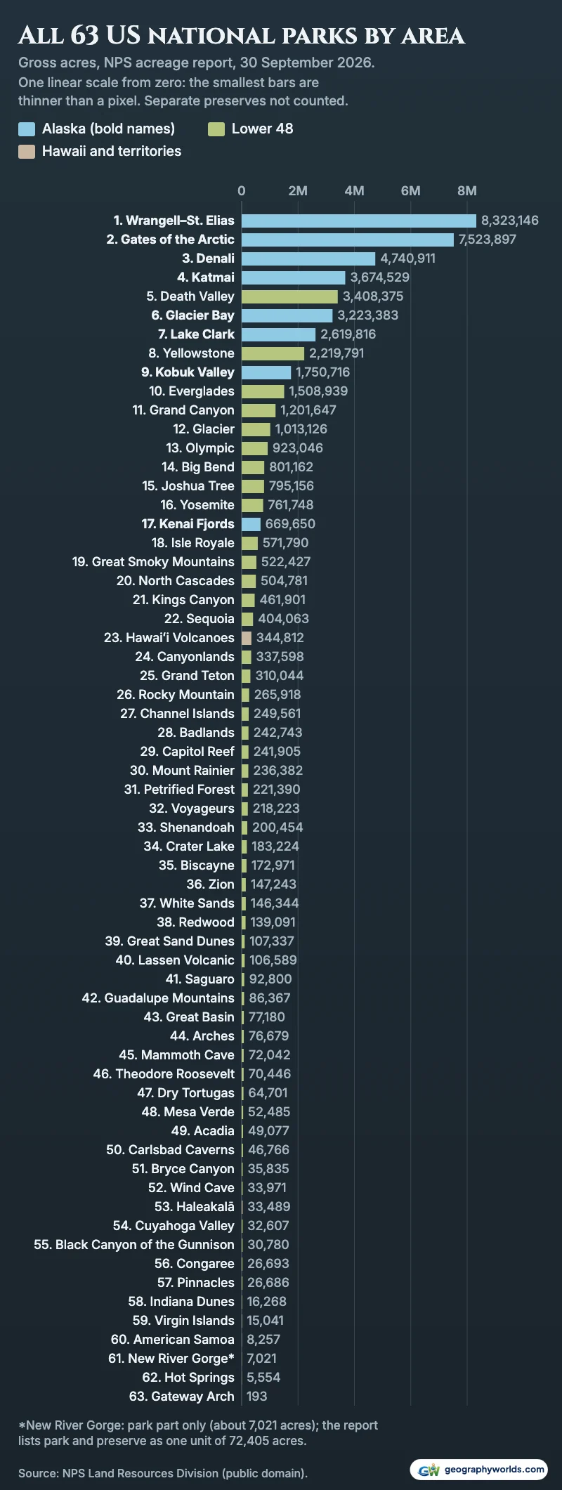
Outside Alaska, Death Valley leads by a wide margin: its 3,408,375 acres are almost exactly Yellowstone and Grand Canyon combined (3,421,438 acres). A 2019 park news release gave it 3,422,024 acres after the John D. Dingell Jr. Act moved about 35,000 acres to it from the Bureau of Land Management; the 2026 report is 13,649 acres lower, a 0.4% difference that changes no ranking. Big Bend and Joshua Tree are almost level, 6,006 acres apart.
Lakes and sea inside the lines
Gross area counts water, and for a few parks water is most of it. Isle Royale, tenth in the lower 48, is an island group in Lake Superior; sampling its boundary against Natural Earth’s 1:10m coastline and lakes, about 74% of the area is lake. Its size also depends on whom you ask: the report’s 571,790 acres are 893 square miles, the boundary polygon measures 862, and the park’s nature page says 850, including submerged land. On any of the three it stays ahead of Great Smoky Mountains (816 square miles).
Biscayne in Florida, 172,971 acres, is 95% water by the park’s own count; the same 1:10m sampling gives about 97%, a little high because the map leaves out the smallest keys. About 47% of Channel Islands’ boundary is sea on the same sampling. Glacier Bay’s fact sheet counts 607,100 acres of marine water, about 19% of the park and the largest marine area the park service manages. A ranking of land alone would push these parks down, but the acreage report does not separate land from water.
The other end: parks measured in hundreds of acres
The smallest national park is Gateway Arch in St. Louis, at 193 gross acres; Wrangell–St. Elias is 43,163 times bigger. Only 89 of those acres are federal, which matches the park’s description of the arch, its museum and 90 acres of landscape plus the Old Courthouse; the other 104 acres inside the boundary belong to others. The report lists its state as Missouri and Illinois.
Next come Hot Springs in Arkansas (5,554 acres), New River Gorge’s park part (about 7,021), American Samoa (8,257) and Virgin Islands (15,041). On federal acres American Samoa, owning nothing, comes last. Ownership is patchier at this end too: Indiana Dunes (16,268 acres), the sixth smallest, has 31% of its boundary area outside federal hands.
About the numbers
Every figure comes from the Land Resources Division’s Listing of Acreage for 30 September 2026, one row per unit; we kept the 63 designated national parks, added Everglades Expansion to Everglades and counted only the park part of New River Gorge. Square miles divide acres by 640. Outlines are the division’s park boundaries, drawn north-up in an equal-area projection centred on each park; for the ten largest parks, and the ten largest in the lower 48, each polygon’s measured area is within 3.6% of the report (the worst is Isle Royale). State areas are the Census Bureau’s 2026 TIGERweb figures, and Connecticut’s outline is the Census 1:5,000,000 cartographic boundary.
You can download the data as a CSV: all 63 parks with gross, federal, park-service, other-public and private acres, the preserve next door, square miles, square kilometres and both rankings. To chart the parks your own way, by state or by how much of each is privately held, Parity can turn that spreadsheet into a chart without code.
- National Park Service, Land Resources Division: Listing of Acreage, quarter ending 30 September 2026: XLSX; public domain (US government work, 17 U.S.C. § 105, per the NPS disclaimer)
- National Park Service, Land Resources Division: Tract and Boundary Data Service (nps_boundary): park and preserve outlines; public domain US government data
- US Census Bureau, TIGERweb States layer (January 2026 vintage): state land and water areas; public domain
- US Census Bureau, 2024 cartographic boundary file, states 1:5,000,000: Connecticut outline; public domain
- Natural Earth 1:10m land and lakes, v5.1.2: public domain; used to estimate the water inside four park boundaries
- Alaska National Interest Lands Conservation Act, Public Law 96-487 (1980)
- US Census Bureau, State Area Measurements (2010)
For how these parks compare with the states that contain them, Alaska included, see our ranking of the largest US states by area.