

Madrid, the capital of Spain and home to roughly 6.7 million people across its metropolitan area, sits near the centre of the Iberian Peninsula at an elevation of about 650 metres on the vast Meseta Central plateau. Its high, inland position makes it one of the highest capital cities in Europe and gives it a markedly continental climate.
Introduction
Madrid occupies an almost geometric centre of Spain, a location that helped shape its rise as the nation's political heart. Unlike most great European capitals, it grew up far from any river mouth, coastline, or major waterway, instead spreading across the elevated tableland that dominates the interior of the Iberian Peninsula. The result is a city defined less by water than by altitude, open skies, and the sweep of the surrounding plateau.
To the northwest rise the peaks of the Sierra de Guadarrama, part of the Sistema Central mountain chain that separates the northern and southern halves of the Meseta. These mountains loom over the city, feeding its rivers, moderating its weather, and providing a green recreational backdrop within easy reach of the urban centre. Understanding Madrid's physical geography, from its lofty plateau to its modest river, is key to understanding how the Spanish capital lives and grows.
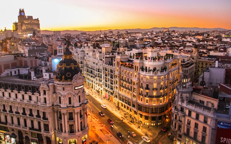
Location & Setting
- Coordinates: 40.4168°N, 3.7038°W
- Elevation: About 650 m above sea level
- Setting: Centre of the Iberian Peninsula, Meseta Central
- Country: Spain
Madrid lies close to the geographic centre of Spain, roughly equidistant from the country's main coasts. This central position is no accident of nature alone: when Philip II made Madrid the permanent seat of the court in 1561, its central location within the peninsula was part of its appeal as a capital from which to govern a sprawling realm. The city therefore sits hundreds of kilometres from the sea in every direction.
At around 650 metres of elevation, Madrid is among the highest capital cities in Europe, its altitude comparable to that of many mountain-fringed towns rather than a coastal metropolis. The surrounding province of Madrid rises even higher toward the northwest, climbing into the Guadarrama range where several summits exceed 2,000 metres. This gradient from plain to mountain gives the region a varied landscape within a relatively short distance of the city.
Physical Geography
- Plateau: Meseta Central, the elevated core of Iberia
- Main river: Manzanares, a small tributary of the Jarama
- Mountains: Sierra de Guadarrama to the northwest
- Terrain: Gently sloping tableland dissected by river valleys
The Meseta Central is a broad, elevated plateau that forms the geological backbone of the Iberian Peninsula. Madrid sits on its southern half, on terrain that slopes gently and is cut by the valleys of small rivers draining toward the Tagus system. The land beneath the city is composed largely of sediments and clays deposited over long periods, gradually shaped by erosion into the terraces and low rises on which the city is built.
The Manzanares River, which flows through Madrid, is a modest stream by the standards of great capital rivers. It rises in the Guadarrama Mountains and flows southward through the city before joining the larger Jarama, which in turn feeds the Tagus. Historically small and seasonal, the Manzanares has been heavily managed, and recent restoration of its urban banks has turned much of its course into a linear riverside park. The Guadarrama Mountains to the northwest are the region's dominant natural feature, catching winter snow and supplying much of the water on which the metropolis depends.
Climate
- Climate type: Continental Mediterranean
- Summer temperatures: Frequently above 35°C in July and August
- Winter temperatures: Cold nights near or below freezing
- Annual rainfall: Roughly 400–450 mm, concentrated in spring and autumn
Madrid's high, inland position gives it a continental version of the Mediterranean climate, with hot summers and cold winters and a large gap between the two. Summers are hot and dry, with July and August temperatures regularly exceeding 35 degrees Celsius under clear skies, while the low humidity and altitude mean nights can cool noticeably. This pattern is often summed up in the old saying about Madrid's air being too thin to blow out a candle yet cold enough to kill a person.
Winters are cold for a southern European capital, with frosty nights, occasional snowfall, and chilly winds spilling off the snow-covered Guadarrama. Rainfall is relatively low and falls mainly in the spring and autumn, leaving the summer months parched. The city's elevation and distance from the moderating influence of the sea are the key reasons its climate swings so sharply between seasons.
Districts & Layout
- Historic core: Old town around Puerta del Sol and the Royal Palace
- Central axis: The Paseo de la Castellana running north–south
- Green space: Retiro Park and the vast Casa de Campo
- Growth pattern: Concentric expansion around a compact centre
Madrid grew outward from a compact medieval and Habsburg-era core centred on the area around the Puerta del Sol and the Royal Palace, which stands on a rise overlooking the Manzanares valley. From this dense historic heart the city expanded in rings, its layout organised around grand boulevards, most notably the long north–south axis of the Paseo del Prado and Paseo de la Castellana that threads through the modern business districts.
Despite its size, Madrid retains generous green spaces. The formal Retiro Park sits just east of the centre, while the enormous Casa de Campo, a former royal hunting ground, provides a large expanse of woodland and open country on the western edge of the city beyond the Manzanares. Newer residential and commercial districts have spread across the plateau in every direction, absorbing surrounding towns into a continuous metropolitan fabric.
Population & Growth
- City population: Around 3.3 million
- Metropolitan area: Approximately 6.7 million
- Rank: Largest city in Spain and one of the largest in the EU
- Role: National capital and dominant economic hub
Madrid is the largest city in Spain, with a municipal population of around 3.3 million and a metropolitan area of roughly 6.7 million people, making it one of the most populous urban regions in the European Union. As the national capital it concentrates government, finance, and corporate headquarters, and it functions as the hub of Spain's road, rail, and air networks, with radial motorways and high-speed rail lines fanning out across the country from the centre.
The city's growth has spread far beyond its historic limits, drawing surrounding municipalities into a broad metropolitan zone across the plateau. This expansion places pressure on the region's limited water resources, which depend heavily on reservoirs fed by the Guadarrama mountains, and on the transport corridors that link the dense core with fast-growing suburbs.
Environmental Challenges
- Air quality: Traffic-related pollution and periodic smog
- Heat: Intense summer heat amplified by the urban heat island
- Water supply: Reliance on mountain reservoirs vulnerable to drought
- Urban sprawl: Continued expansion across the surrounding plateau
Madrid faces environmental pressures typical of a large, car-oriented capital in a warming climate. Traffic emissions have periodically pushed air pollution above healthy limits, prompting low-emission zones and restrictions in the city centre. Summer heat is a growing concern, intensified by the urban heat island effect that keeps built-up areas warmer than the surrounding countryside, especially at night.
Water security is a long-standing issue for a city on a dry plateau far from any major river. Madrid relies on a network of reservoirs in the Guadarrama and other nearby ranges, storage that can be strained during the recurrent droughts of the Mediterranean climate. Managing sprawl, greening the urban fabric, and restoring the Manzanares riverfront are among the strategies the city has adopted to make its high, thirsty setting more liveable.
Questions and Answers
How high is Madrid?
The city centre sits at about 650 metres above sea level on the Meseta Central, making Madrid one of the highest capital cities in Europe.
What river runs through Madrid?
The Manzanares, a small river rising in the Sierra de Guadarrama, flows through the city before joining the Jarama and ultimately the Tagus.
Why does Madrid have such hot summers and cold winters?
Its high altitude and position deep in the interior, far from the moderating influence of the sea, give it a continental climate with large temperature swings between seasons.
Key Facts
- Madrid sits at about 650 m on the Meseta Central, among Europe's highest capitals.
- It lies near the geographic centre of Spain, far from any coast.
- The small Manzanares River is its main watercourse, feeding into the Tagus system.
- Its continental climate brings hot, dry summers and cold winters.
- The metropolitan area is home to roughly 6.7 million people.