
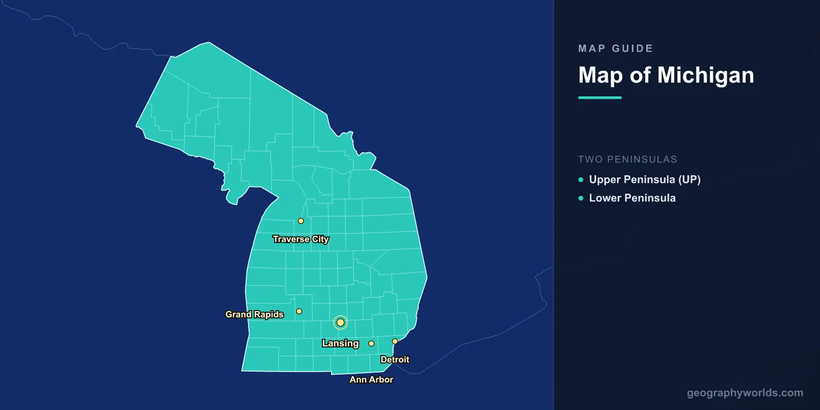
Michigan is a midwestern US state uniquely divided into two large landmasses — the Upper Peninsula (UP) and the Lower Peninsula — connected by the Mackinac Bridge. It is bordered by four of the five Great Lakes (Superior, Michigan, Huron, and Erie) and has the longest freshwater coastline of any state, stretching over 5,200 kilometers.
Introduction
Known as the "Great Lakes State," Michigan's geography is defined almost entirely by water. The state touches more Great Lakes than any other, and no point in Michigan is more than 137 kilometers from a Great Lake shoreline. From the wilderness forests of the Upper Peninsula to the automotive heartland of Detroit in the Lower Peninsula, Michigan's map tells a story of natural beauty and industrial might.

The Two Peninsulas
Michigan is the only US state divided into two non-contiguous peninsulas, separated by the Straits of Mackinac where Lake Michigan meets Lake Huron.
- Upper Peninsula (UP): Roughly 42,600 km², heavily forested and sparsely populated with about 300,000 residents. Features the Porcupine Mountains, Pictured Rocks National Lakeshore, and Tahquamenon Falls. The UP borders Wisconsin to the southwest and is separated from Canada by Lake Superior and the St. Marys River.
- Lower Peninsula: Shaped like a mitten (Michiganders often hold up their hand to show where they live), it is the more populous half with nearly 10 million residents. Contains Detroit, Grand Rapids, Lansing, Ann Arbor, and most of the state's economic activity.
The Mackinac Bridge, completed in 1957, spans 8 km across the Straits of Mackinac and is one of the longest suspension bridges in the Western Hemisphere. Before the bridge, ferries were the only connection between the two peninsulas.
Great Lakes Borders
- Lake Superior: Borders the UP to the north. The largest Great Lake by surface area (82,100 km²) and the deepest (406 m).
- Lake Michigan: Borders the Lower Peninsula to the west and the UP to the south. The only Great Lake entirely within US borders.
- Lake Huron: Borders the Lower Peninsula to the east and the UP to the south. Contains Manitoulin Island (Canadian) and Michigan's own Mackinac Island.
- Lake Erie: Borders a short stretch of southeastern Michigan near Monroe and Toledo.
These four lakes give Michigan over 5,200 km of Great Lakes shoreline — more freshwater coastline than any political subdivision on Earth. The lakeshores include towering sand dunes along Lake Michigan, rocky cliffs on Lake Superior, and sandy beaches on Lake Huron.
Major Cities
- Detroit: Southeastern Michigan on the Detroit River at 42.3°N, 83.0°W. Population ~640,000 (city), 4.3 million (metro). The Motor City and birthplace of the American auto industry.
- Grand Rapids: Western Lower Peninsula at 43.0°N, 85.7°W. Population ~200,000. Michigan's second-largest city, known for furniture manufacturing and craft breweries.
- Lansing: Central Lower Peninsula at 42.7°N, 84.6°W. The state capital and home to Michigan State University.
- Ann Arbor: Southeastern Michigan at 42.3°N, 83.7°W. Home to the University of Michigan, a major research and cultural centre.
- Traverse City: Northwestern Lower Peninsula at 44.8°N, 85.6°W. Known as the Cherry Capital of the World, gateway to Sleeping Bear Dunes.
Landforms & Physical Geography
- Highest Point: Mount Arvon, 603 m, in the UP's Baraga County
- Area: 250,487 km² (11th largest US state)
- Islands: Over 64,000 inland lakes, plus major islands including Isle Royale and Mackinac Island
Michigan's landscape was shaped almost entirely by glacial activity during the last Ice Age. The glaciers carved the Great Lakes basins, deposited the sandy soils that form the famous Lake Michigan dunes, and left behind thousands of inland lakes. Sleeping Bear Dunes National Lakeshore features perched dunes rising up to 140 meters above Lake Michigan.
The Upper Peninsula is dominated by the ancient Canadian Shield rocks in the west, including iron and copper ranges that fueled 19th-century mining booms. The Porcupine Mountains in the western UP reach 603 meters at Mount Arvon, the state's highest point. Waterfalls are abundant in the UP, with Tahquamenon Falls being one of the largest east of the Mississippi.
Borders & Position on the Map
Michigan sits in the north-central United States between roughly 41.7°N and 47.5°N latitude. The Lower Peninsula borders Ohio and Indiana to the south. The Upper Peninsula borders Wisconsin to the southwest. Michigan shares an extensive international border with the Canadian province of Ontario, running through Lake Superior, Lake Huron, the St. Clair River, Lake St. Clair, and the Detroit River.
The Ambassador Bridge and the Detroit-Windsor Tunnel connect Detroit to Windsor, Ontario, forming one of the busiest international border crossings in North America.
Key Facts
- Michigan is split into two peninsulas connected by the 8 km Mackinac Bridge.
- It borders four of the five Great Lakes: Superior, Michigan, Huron, and Erie.
- The state has over 5,200 km of Great Lakes coastline, the most freshwater shoreline of any state.
- Detroit is the largest city, and Lansing is the state capital.
- Glaciers shaped Michigan's landscape, leaving over 11,000 inland lakes.
Fun Facts
- Michigan residents point to spots on their hand (shaped like the Lower Peninsula mitten) to show where they live.
- Isle Royale in Lake Superior is a national park accessible only by boat or seaplane, home to wolves and moose.
- Michigan has more lighthouses than any other US state, with over 120 along its shores.
- The Keweenaw Peninsula in the UP receives an average of 500 cm of snowfall annually, earning it the nickname "Copper Country."
Final Thoughts
Michigan's map is unlike any other US state, defined by its two peninsulas and four Great Lakes. The state's geography ranges from the industrial southeast around Detroit to the wilderness forests of the Upper Peninsula, from towering sand dunes on Lake Michigan to the rocky Superior shoreline. Understanding Michigan's map means appreciating the profound influence of water on every aspect of the state's landscape, economy, and culture.
Test Your Knowledge!
Think you know where things are on the map? Test your skills!
Play Geography Games →