

The Partition of British India on August 15, 1947, was one of the most dramatic geographic reconfigurations of the 20th century. A single subcontinent was divided into two nations, India and Pakistan (the latter comprising two geographically separate wings, West and East Pakistan, separated by 1,600 kilometers of Indian territory).
Introduction
The Partition was a geographic catastrophe. Hastily drawn by British lawyer Cyril Radcliffe, who had never visited India, the boundary line cut through the provinces of Punjab and Bengal, splitting communities, farms, villages, and families. The result was the largest mass migration in human history: roughly 15 million people displaced and between 200,000 and 2 million killed in sectarian violence.
Geographic Context
- British India Area: ~4.4 million km²
- Population at Partition: ~390 million
- Division Basis: Religious demographics (Muslim-majority to Pakistan)
- Radcliffe Line: Drawn in 5 weeks by a British lawyer
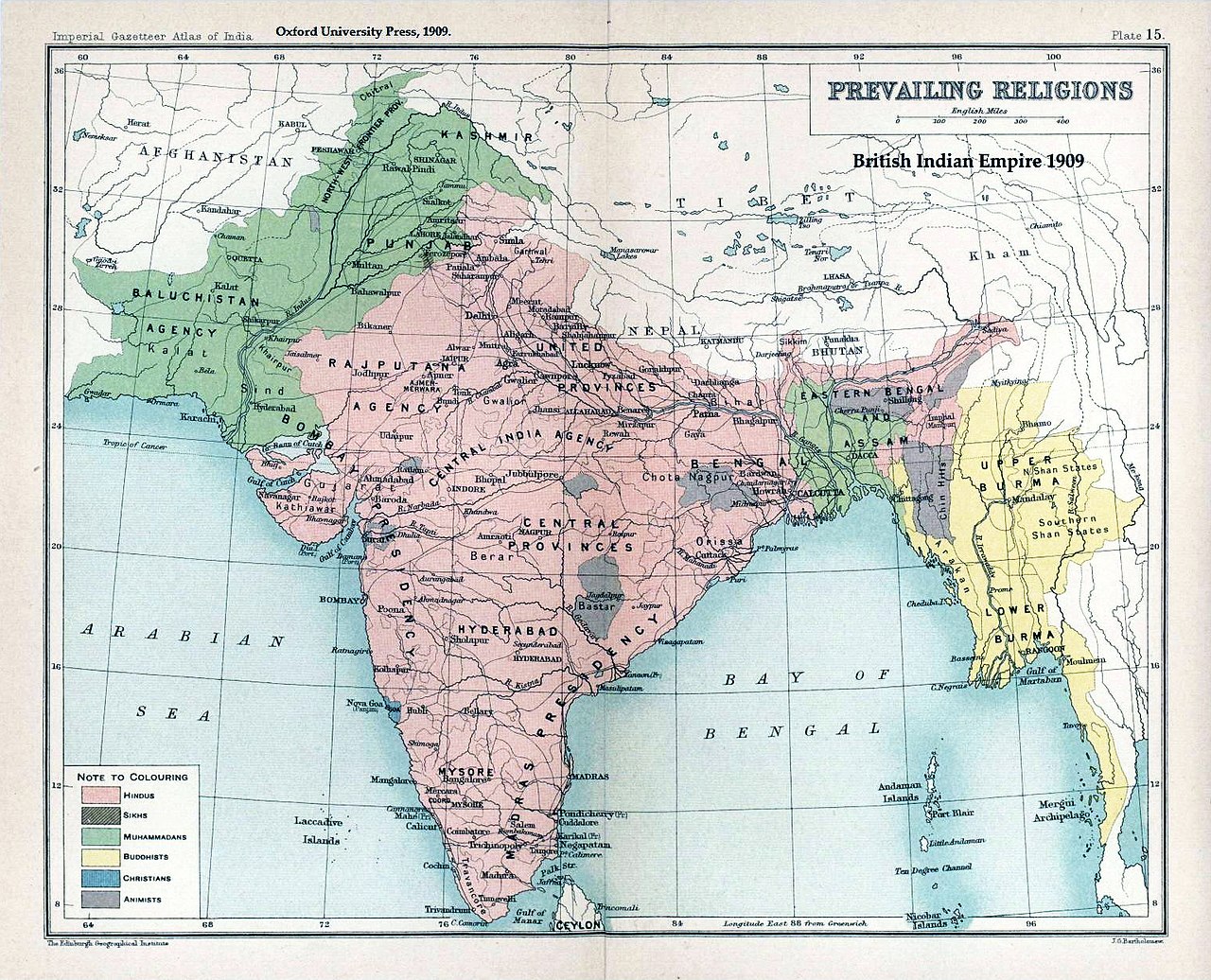
British India was a geographic unity: the Indian subcontinent, bounded by the Himalayas to the north, the Indian Ocean to the south, and the Hindu Kush to the northwest. Its major river systems, the Indus, Ganges, and Brahmaputra, connected rather than divided the territory. Partition cut across these natural geographic connections.
The Radcliffe Line was drawn primarily on the basis of religious demographics in the provinces of Punjab and Bengal, the two regions with the most mixed Hindu-Muslim-Sikh populations. Radcliffe had just five weeks to draw a border affecting hundreds of millions of people, using outdated census data and inaccurate maps.
Key Events
- Mountbatten Plan: June 3, 1947
- Radcliffe Award: August 17, 1947 (published after independence)
- Mass Migration: 1947-1948 (15 million displaced)
- East Pakistan Independence: 1971 (became Bangladesh)
The Partition border was not announced until August 17, two days after independence, leaving millions uncertain about which country they would live in. When the line was revealed, communities that had coexisted for centuries were suddenly on opposite sides of an international border.
The Partition of Punjab was particularly devastating. The province was split roughly in half, with the canal colonies of western Punjab going to Pakistan and the eastern half to India. The fertile Indus river irrigation system, built as a single integrated network, was divided between two hostile nations, creating a water dispute that persists today.
Territorial Changes
- India: ~3.3 million km²
- West Pakistan: ~0.8 million km²
- East Pakistan: ~0.15 million km² (Bangladesh from 1971)
- Princely States: 565 had to choose India or Pakistan
The Partition created one of the most unusual geographic configurations in modern history: Pakistan consisted of two wings separated by 1,600 kilometers of Indian territory. West Pakistan (modern Pakistan) and East Pakistan (modern Bangladesh) had no geographic connection except by air or sea. This geographic absurdity would lead to Bangladesh's independence in 1971.
The 565 princely states that had been under British suzerainty but not direct control had to choose which nation to join. Most decided based on geography and demographics, but several, most notably Kashmir, Hyderabad, and Junagadh, became flash points. Kashmir's unresolved status remains the most dangerous geographic legacy of Partition.
Lasting Impact
- Kashmir Conflict: Ongoing since 1947
- Indus Water Treaty: 1960 (divided river system)
- Nuclear Rivals: Both nations became nuclear powers
- Bangladesh: Separated from Pakistan in 1971
The Kashmir conflict is Partition's most dangerous geographic legacy. The princely state of Jammu and Kashmir, with a Muslim-majority population but a Hindu ruler, became contested territory. India, Pakistan, and China all control portions, and the region has been the site of three wars and remains one of the most militarized zones on Earth.
The Indus Waters Treaty of 1960, brokered by the World Bank, divided the Indus river system between India and Pakistan: the three eastern rivers (Ravi, Beas, Sutlej) to India, and the three western rivers (Indus, Jhelum, Chenab) to Pakistan. This geographic division of a single river system is a permanent physical consequence of Partition.
Modern Relevance
- Border Security: One of the most militarized borders in the world
- Divided Families: Some families still separated since 1947
- Visa Restrictions: Extremely difficult cross-border travel
The India-Pakistan border is one of the most heavily militarized in the world. The Wagah border ceremony, where soldiers from both sides perform an elaborate flag-lowering ritual, has become a symbol of the geographic and political division. The Line of Control in Kashmir is patrolled by hundreds of thousands of troops from both nations.
Partition's geographic division continues to affect daily life. Families separated in 1947 often cannot visit each other due to restrictive visa policies. The geographic complementarity that once made the subcontinent a functional economic unit, with Punjab's wheat, Bengal's jute, and Gujarat's cotton all serving an integrated market, was shattered and never restored.
Key Facts
- The Partition displaced approximately 15 million people, the largest mass migration in human history.
- Between 200,000 and 2 million people were killed in Partition violence.
- Pakistan was created as two wings separated by 1,600 km of Indian territory.
- The Radcliffe Line was drawn in just 5 weeks by a British lawyer who had never visited India.
- Kashmir remains divided between India, Pakistan, and China, with no resolution since 1947.
Fun Facts
- Cyril Radcliffe, who drew the Partition boundary, was chosen specifically because he had never been to India and was therefore presumed to be impartial. He later said it was the most difficult task he had ever undertaken.
- The India-Pakistan border at Punjab is the only international border visible from space at night, because India illuminates it with floodlights for security.
- The Kartarpur Corridor, opened in 2019, allows Indian Sikhs to visit a sacred shrine just 4 km inside Pakistan without a visa, one of the few geographic concessions across the Partition border.
- When the Radcliffe Line was finally published, it cut through the middle of some villages, placing the mosque on one side and the temple on the other.
Final Thoughts
The Partition of India was one of the 20th century's most traumatic geographic events. A hastily drawn line divided a subcontinent, displaced 15 million people, and created conflicts that persist eight decades later. Partition demonstrates that geographic divisions, once imposed, can become seemingly permanent features of the political landscape.
Test Your Knowledge!
Think you know your historical geography? Try our interactive geography quiz!
Play Country Quiz →