

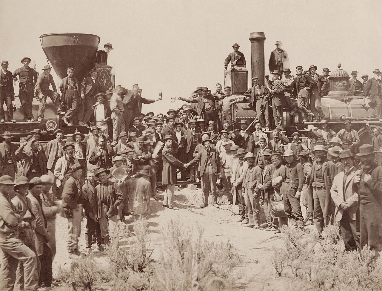
The First Transcontinental Railroad, completed on May 10, 1869, at Promontory Summit, Utah, was the greatest engineering achievement of 19th-century America. Stretching 1,776 miles from Omaha, Nebraska, to Sacramento, California, the railroad crossed the Great Plains, scaled the Rocky Mountains, traversed the deserts of Nevada and Utah, and punched through the granite wall of the Sierra Nevada. It reduced cross-country travel time from four to six months to just six days.
Introduction
Two companies built the railroad from opposite ends: the Central Pacific Railroad built eastward from Sacramento, and the Union Pacific Railroad built westward from Omaha. Together they employed over 20,000 workers — including thousands of Chinese immigrants and Irish laborers — in one of the most dangerous construction projects in American history. The railroad's completion fundamentally altered the geographic and economic relationship between the eastern and western halves of the United States.
The Route
- Union Pacific: 1,086 miles, Omaha to Promontory Summit
- Central Pacific: 690 miles, Sacramento to Promontory Summit
- Meeting Point: Promontory Summit, Utah, May 10, 1869
- Elevation Range: Sea level (Sacramento) to 8,247 ft (Sherman Summit, WY)
The Union Pacific built west from Omaha across the Great Plains, following the Platte River valley — the same corridor used by the Oregon Trail. The route climbed steadily from 1,090 feet at Omaha to 8,247 feet at Sherman Summit in the Laramie Mountains of Wyoming, the highest point on the entire transcontinental route. West of Wyoming, the railroad descended through the Wasatch Range into the Great Salt Lake basin.
The Central Pacific faced the more daunting geographic challenge: crossing the Sierra Nevada. From Sacramento at near sea level, the railroad climbed to 7,042 feet at Donner Pass in just 105 miles. The Sierra crossing required 15 tunnels through solid granite, the longest being the 1,659-foot Summit Tunnel. East of the Sierra, the Central Pacific crossed the arid Great Basin of Nevada, a desolate landscape of sagebrush, alkali flats, and extreme temperature swings.
Construction Challenges
- Sierra Tunnels: 15 tunnels through granite, mostly by hand
- Chinese Workers: ~12,000, comprising 80% of Central Pacific workforce
- Nitroglycerin: Used for blasting after black powder proved too slow
- Winter 1866–67: 44 storms, 40+ feet of snow in the Sierra
The Sierra Nevada crossing was the most technically challenging portion of the railroad. Chinese workers, who comprised roughly 80 percent of the Central Pacific's workforce, carved 15 tunnels through solid granite using hand drills, black powder, and later nitroglycerin. The Summit Tunnel at Donner Pass required 24-hour shifts drilling from both ends and a central shaft. It took 15 months to complete the 1,659-foot bore.
The winter of 1866–67 was catastrophic: 44 storms dumped over 40 feet of snow on the Sierra. Workers lived and worked in tunnels beneath the snowpack, with avalanches killing dozens. On the plains, Union Pacific workers faced different challenges: extreme heat, lack of water, and occasional conflicts with Native Americans whose lands the railroad crossed. Construction consumed 400 tons of iron rails and 2,500 ties per mile.
Economic Transformation
- Travel Time: Reduced from 4–6 months to 6 days
- Freight Costs: Dropped from $1,000/ton to $65/ton (NYC to SF)
- Land Grants: 20 million acres given to railroad companies
- Towns Created: Hundreds of new towns along the route
The railroad's economic impact was transformative. Before 1869, shipping a ton of freight from New York to San Francisco cost roughly $1,000 via clipper ship around Cape Horn — a journey of 15,000 miles taking four to six months. The railroad reduced this to approximately $65 per ton and six days. Passengers who had risked their lives on overland trails or endured months at sea could now cross the continent in comfort.
The federal government granted the railroad companies roughly 20 million acres of land along the route — a checkerboard pattern of alternating sections stretching 10 to 20 miles on either side of the tracks. The railroads sold this land to settlers, creating hundreds of new towns and agricultural communities across the West. Cities like Cheyenne, Laramie, Reno, and Ogden owe their existence to the railroad.
Impact on Native Nations & Bison
- Bison Herds: Railroad split herds into northern and southern groups
- Hunting Access: Enabled mass commercial bison hunting
- Treaty Violations: Railroad crossed lands guaranteed by treaties
- Military Advantage: Allowed rapid deployment of troops to the West
The transcontinental railroad dealt a devastating blow to the Great Plains Indigenous nations. The railroad physically divided the bison herds into northern and southern groups, disrupting their migration patterns. More critically, the railroad enabled mass commercial bison hunting — professional hunters shipped millions of hides east by rail, reducing the herds from tens of millions to near extinction by the 1880s.
The railroad also allowed the US Army to rapidly deploy troops across the West, shifting the military balance decisively against Native nations. Many of the post-Civil War Indian Wars were fought to protect railroad construction and the settlements it spawned. The railroad crossed lands guaranteed to Native nations by treaty, and the government used military force to enforce railroad access.
Geographic Legacy
- Time Zones: Railroad led to adoption of standard time zones in 1883
- Urban Growth: Created a string of cities from Omaha to Sacramento
- Modern Route: Roughly followed by Interstate 80
- Railroad Network: Spawned additional transcontinental routes by 1900
The transcontinental railroad created the need for standard time zones. Before the railroad, every town set its clocks to local solar time, creating chaos for scheduling. In 1883, the railroads imposed four standard time zones across the country — a system adopted by the federal government in 1918. The railroad literally standardized American geography.
The route established by the transcontinental railroad remains a primary east-west transportation corridor. Interstate 80, from Omaha to Sacramento, roughly follows the original route. The railroad spawned additional transcontinental lines — the Southern Pacific, Northern Pacific, Great Northern, and Atchison, Topeka and Santa Fe — by 1900, creating the rail network that knitted the continental United States into a single economic market.
Key Facts
- The railroad stretched 1,776 miles from Omaha to Sacramento, completed May 10, 1869.
- Cross-country travel time dropped from 4–6 months to 6 days.
- About 12,000 Chinese workers built 80% of the Central Pacific's section.
- Sherman Summit in Wyoming (8,247 ft) was the highest point on the route.
- The railroad led to the adoption of standard time zones in 1883.
Fun Facts
- The golden spike driven at Promontory Summit was connected to a telegraph wire, and the hammer blow was transmitted nationwide — the first live coast-to-coast media event.
- Central Pacific workers advanced just 8 inches per day through the hardest granite of the Summit Tunnel.
- The railroad companies laid track at extraordinary speed in the final race — the Union Pacific set a record of 10 miles of track in a single day on April 28, 1869.
- Promontory Summit, the historic meeting point, was bypassed by a shorter rail route in 1904 and is now a remote national historic site.
Final Thoughts
The Transcontinental Railroad was the infrastructure project that physically united the United States from coast to coast. Its 1,776-mile route across plains, mountains, and deserts transformed travel times, freight costs, and settlement patterns. The railroad created cities, destroyed bison herds, displaced Indigenous nations, and standardized American timekeeping. Its geographic legacy — the corridors, cities, and connections it established — remains embedded in the American landscape today.
Test Your Knowledge!
Think you know American history's geographic impact? Try our interactive geography quiz!
Play Geography Games →