
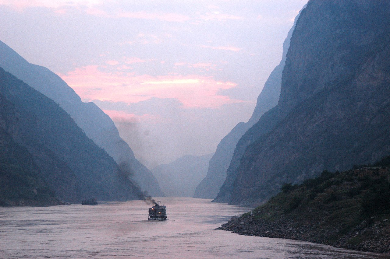
The Yangtze is Asia's longest river and the third longest in the world, after the Nile and the Amazon. It rises on the Tibetan Plateau at an elevation of around 5,000 metres, descends through deep gorges into the Sichuan Basin, then meanders across the central Chinese plains before reaching the East China Sea at Shanghai. Its total length is approximately 6,300 kilometres. Its drainage basin covers nearly 1.8 million square kilometres — roughly one-fifth of China's total area — and contains about 400 million people, more than the entire population of the United States. The river is so central to Chinese civilisation that the Chinese name for it, Chang Jiang, simply means "long river"; "Yangtze" is the older Western name derived from a local term that was misapplied by 19th-century European travellers and never quite shaken off.
The Three Sections
The river is conventionally divided into Upper, Middle, and Lower Yangtze, with the dividing points at Yichang in Hubei province (where the river emerges from the Three Gorges) and at Hukou in Jiangxi province (where Poyang Lake joins it). The Upper Yangtze, from the Tibetan source to Yichang, is the high, steep, gorge-cutting section. The Middle Yangtze, from Yichang to Hukou, is the broad floodplain section where the river meanders through some of the most densely populated agricultural land in the world. The Lower Yangtze, from Hukou to the sea, is the navigable industrial heartland of central China — Wuhan, Nanjing, and Shanghai all sit on or near this section.
The Three Gorges
The Yangtze's most dramatic stretch is the Three Gorges — Qutang, Wu, and Xiling — that run for 200 kilometres between Chongqing and Yichang. The gorges are extraordinarily scenic: sheer limestone cliffs rising up to 1,200 metres from the water on either side, the river funneled into a narrow channel between them. They have been a major subject of Chinese painting and poetry for over a millennium. They were also extremely dangerous to navigate before the 20th century — the current was strong, the channel was full of rocks and rapids, and shipwrecks were common. Cargoes were often portaged around the worst sections by gangs of pullers ("trackers") who hauled boats upstream using ropes from paths cut into the cliff faces. The opening of the gorges to safer modern navigation depended on a sustained programme of dredging, blasting, and signal-installation in the 1950s through the 1980s.
The Three Gorges Dam
The Three Gorges Dam, built across the Yangtze just downstream of the gorges near Sandouping in Hubei province, is the largest hydroelectric power station in the world by installed capacity. Construction began in 1994 and was substantially completed in 2012. The dam is 2,335 metres long and 185 metres tall. The reservoir behind it stretches back about 600 kilometres upstream, partially flooding the Three Gorges themselves and submerging the cities and villages along the gorge banks. The dam's 32 main turbines have a combined generating capacity of 22,500 megawatts — roughly the output of 20 large nuclear reactors. The annual energy production is on the order of 100 terawatt-hours, equivalent to about 2 percent of China's national electricity consumption.
The dam's construction required the relocation of approximately 1.3 million people from areas flooded by the reservoir. Whole cities and county seats were dismantled and rebuilt on higher ground. Historic and archaeological sites were either submerged, relocated stone by stone to higher elevations, or photographed and documented before being lost. The relocation programme was the largest of any infrastructure project in modern history. It produced both significant grievance among the displaced communities and significant economic dislocation for the regions that received them.
Flooding
The Yangtze's middle and lower reaches are catastrophically prone to flooding. The 1931 China floods — driven primarily by Yangtze and Huai River overflow — killed somewhere between 1 and 4 million people in central China, making them one of the deadliest natural disasters in recorded human history. The 1954 floods killed an estimated 30,000. The 1998 floods killed about 4,000. Flood control was one of the principal justifications for the Three Gorges Dam, which reduces downstream flood peaks by storing flood waters in its reservoir. The dam has worked broadly as designed in this respect, reducing peak flood discharges downstream of Yichang by 20-40 percent in major flood years. The 2020 flood season tested the dam to near its design limits — discharge through the dam exceeded 75,000 cubic metres per second at the peak — but the downstream cities were spared the worst.
The Cities Along the River
Several of China's most important cities sit on the Yangtze. Chongqing, at the head of the navigable section in southwestern China, has a metropolitan population over 30 million and was the wartime capital of the Republic of China from 1937 to 1945. Wuhan, in the central section, is a major industrial and educational centre of about 11 million people and was the original epicentre of the COVID-19 pandemic in late 2019. Nanjing, near the lower end, was the capital of multiple Chinese dynasties and the Republic of China at various points; it has about 9 million residents today. Shanghai, at the mouth, is China's largest city (24 million metropolitan) and one of the world's busiest ports.
The Dolphin That Disappeared
The Yangtze was one of only six rivers in the world that historically hosted a freshwater dolphin species — the baiji, or Chinese river dolphin. The baiji was a pale-coloured, near-blind cetacean adapted to the muddy water of the Yangtze, communicating and navigating primarily by sonar. The species was driven to functional extinction by the late 20th century by a combination of fishing-net entanglement, ship-strike injuries, dam construction blocking spawning movements of the fish it ate, and the cumulative effects of pollution. A 2006 expedition searched the river for survivors and found none. The baiji is now listed as either functionally extinct or critically endangered (some hold out hope for a relict population), and is the only known cetacean species driven to extinction by human activity. The closely related Yangtze finless porpoise — a smaller species still present in the river — is itself critically endangered, with population estimates of around 1,000.
The Mouth
The Yangtze enters the East China Sea through a wide estuary north of Shanghai. The mouth is divided by the island of Chongming — at 1,267 square kilometres, the third-largest island of China — into a north and south channel. The south channel carries most of the river's discharge and most of the shipping traffic. Shanghai's port facilities have expanded along this south channel and onto the artificial Yangshan Deep-Water Port further offshore, which was built starting in 2002 specifically to handle the largest container ships that cannot reach the older Shanghai port directly. The Yangtze delta region produces about 20 percent of China's GDP, making it the most economically productive river basin in the world.
The South-North Water Transfer
The Yangtze's waters are not just consumed in their own basin. China's South-North Water Transfer Project, partially completed in 2014, diverts water from the Yangtze basin north toward Beijing and the perpetually water-short North China Plain. Three transfer routes were planned: the Eastern Route (operational since 2013) takes water from the lower Yangtze near Jiangsu province; the Central Route (operational since 2014) takes water from Danjiangkou Reservoir on the Hanshui, a major Yangtze tributary; and the Western Route, the most ambitious, would transfer water from the high upper Yangtze across the mountains to the Yellow River. The Western Route is still in planning. The Eastern and Central routes together divert around 35 cubic kilometres of water per year — a substantial fraction of the Yangtze's annual flow — to support the urban and agricultural areas of north China.
The Future
The Yangtze, more than perhaps any other major river, has been remade by 20th and 21st century engineering. The Three Gorges Dam has fundamentally altered the river's flow regime, its sediment transport (much of the silt that historically built up the delta is now trapped behind the dam), and its biological communities. The cities along its banks depend on the engineering working as designed. The dam itself has a finite life — its reservoir is gradually filling with sediment and will need either dredging or eventual decommissioning over the centuries — but no clear plan for that exists yet. Climate change is altering the river's flow patterns in ways that are not entirely predictable. The Yangtze of the next century will be a different river from the one that defined the Chinese landscape for the previous several millennia, and the politics of that transition are still being worked out.