
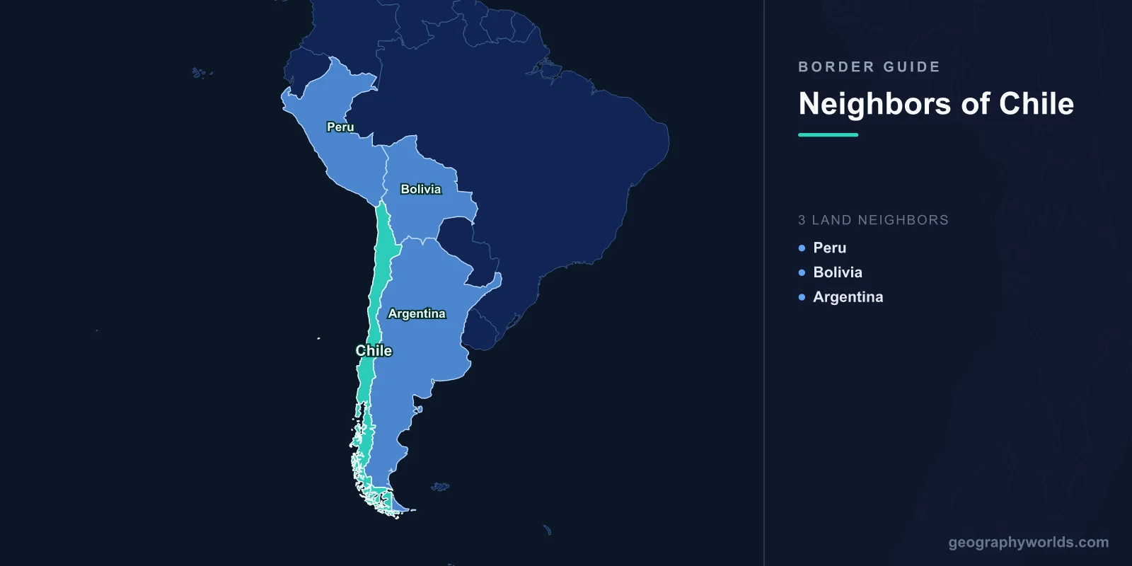
Chile shares land borders with three countries: Peru to the north, Bolivia to the northeast, and Argentina along its entire eastern edge. Despite its extraordinary length of over 4,300 kilometers from north to south, Chile is remarkably narrow, averaging just 177 kilometers wide.
Introduction
Chile's borders are almost entirely defined by the Andes Mountains, which form the country's eastern spine from the Atacama Desert to Tierra del Fuego. This gives Chile some of the most dramatic and high-altitude borders in the world, crossing active volcanoes, glacial lakes, vast salt flats, and peaks exceeding 6,000 meters. Chile is the longest north-south country in the world, and its borders reflect this extraordinary geographic range.

Overview of Chile's Borders
- Total Land Borders: 6,339 km
- Number of Neighbors: 3 countries
- Longest Border: Argentina (5,308 km)
- Shortest Border: Peru (168 km)
Chile's borders are overwhelmingly Andean. The Argentine border alone accounts for over 83% of Chile's total land boundary, running the entire length of the country along the Andes crest. The Bolivian border crosses the Altiplano and volcanic high desert, while the short Peruvian border crosses the coastal Atacama. All three borders are at high altitude for significant portions of their length.
Chile's current borders were established primarily through the War of the Pacific (1879-1884) and subsequent treaties. Before the war, Chile was significantly smaller, and Bolivia had a Pacific coastline. Chile's annexation of the Atacama region, rich in nitrates and later copper, transformed the country into a mining powerhouse and left Bolivia permanently landlocked, a source of ongoing diplomatic tension.
Northern Neighbor: Peru
- Border Length: 168 km
- Key Feature: Atacama Desert, Pacific coast
- Border City: Tacna (Peru) - Arica (Chile)
- Historical Context: Established by Treaty of Lima (1929)
Chile's border with Peru is its shortest at just 168 km, crossing the hyper-arid Atacama Desert near the Pacific coast. The border runs roughly along the Concordia Line established by the 1929 Treaty of Lima, which returned the city of Tacna to Peru while Chile retained Arica. The nearby Atacama region receives virtually no rainfall and is considered the driest non-polar desert on Earth.
Despite the short border, the Peru-Chile relationship carries significant historical weight from the War of the Pacific. A maritime boundary dispute was resolved by the International Court of Justice in 2014. Today, the Tacna-Arica corridor is a busy border crossing, and Chile's northern Atacama is home to some of the world's most productive copper mines and most advanced astronomical observatories, which take advantage of the exceptionally clear desert skies.
Northeastern Neighbor: Bolivia
- Border Length: 942 km
- Key Features: Altiplano, salt flats, volcanoes
- Elevation: Most of the border above 3,500 m
- Diplomatic Issue: Bolivia's loss of sea access in 1884
The Bolivian border runs 942 km across some of the highest and most desolate terrain in the Americas. The border crosses the Altiplano at elevations above 3,500 meters, passing near the massive Salar de Uyuni (on the Bolivian side) and through a landscape of volcanic peaks, geysers, and flamingo-dotted high-altitude lakes. The El Tatio geyser field near the border is the largest in the Southern Hemisphere.
Bolivia's loss of its Pacific coastline to Chile in the War of the Pacific remains the defining issue in bilateral relations. Bolivia has never accepted the loss and has repeatedly sought to negotiate or litigate sovereign sea access, most recently at the International Court of Justice in 2018, where the court ruled that Chile was not obligated to negotiate. Despite this diplomatic tension, Chile provides Bolivia with transit rights through the port of Arica under the 1904 Treaty of Peace.
Eastern Neighbor: Argentina
- Border Length: 5,308 km
- Key Features: Andes Mountains, Patagonia, Tierra del Fuego
- Highest Point Near Border: Ojos del Salado (6,893 m)
- Notable Features: Torres del Paine, Lake District, glaciers
The Argentina-Chile border at 5,308 km is the third-longest international border in the world, following the Andes from the Atacama in the north to Tierra del Fuego in the south. The border passes near some of the highest peaks in the Americas, including Ojos del Salado (6,893 m), the world's highest volcano, and Aconcagua (6,961 m), the Western Hemisphere's tallest mountain. The Lake District region features stunning glacial lakes straddling the border.
Patagonia, the vast southern region shared between the two countries, features the spectacular Torres del Paine on the Chilean side and Los Glaciares National Park on the Argentine side. The Southern Patagonian Ice Field, the world's third-largest ice reserve, straddles the border. Tierra del Fuego, the archipelago at the southern tip, is divided between the two countries, with the Strait of Magellan forming Chile's southern waterway to the Pacific.
Cross-Border Relations and Trade
- Pacific Alliance: Chile is a founding member
- Top Trade Partner: China globally; Argentina in region
- Bolivia Dispute: Ongoing diplomatic tension over sea access
- Andean Crossings: Limited by extreme altitude and weather
Chile's economic model as South America's most open and trade-oriented economy shapes its border relations. Chile is a founding member of the Pacific Alliance and has free trade agreements with over 60 countries. Copper exports from the Atacama mines near the Bolivian and Peruvian borders account for a significant portion of national revenue. Cross-border trade with Argentina is substantial but constrained by the limited number of Andean crossings.
Chile and Argentina resolved their last major border dispute, over the Beagle Channel, through Vatican-mediated arbitration in 1984. Since then, relations have been largely cooperative, with joint mining projects and infrastructure development. The proposed Agua Negra Tunnel would create a year-round crossing between the two countries, replacing the often snow-closed mountain passes. Chile continues to grant Bolivia transit access to its ports, though the broader sovereignty dispute remains unresolved.
Key Facts
- Chile borders 3 countries: Peru, Bolivia, and Argentina.
- The Chile-Argentina border at 5,308 km is the third-longest international border in the world.
- Chile stretches over 4,300 km from north to south, making it the longest north-south country in the world.
- Ojos del Salado (6,893 m) on the Argentine border is the world's highest volcano.
- Bolivia lost its Pacific coast to Chile in the War of the Pacific (1879-1884).
Fun Facts
- Chile is so narrow that no point in the country is more than 177 km from the ocean on average.
- The Atacama Desert near the Peru border is so dry that NASA uses it to test Mars rovers.
- The Southern Patagonian Ice Field on the Argentine border is the largest ice mass in the Southern Hemisphere outside Antarctica.
- Chile's Carretera Austral highway runs parallel to the Argentine border through some of Patagonia's most spectacular scenery.
Final Thoughts
Chile's three borders trace one of the most geographically extreme frontiers on Earth. From the bone-dry Atacama at the Peruvian border to the volcanic Altiplano shared with Bolivia and the 5,308 km Andean wall alongside Argentina, Chile's borders define a country of extraordinary length and slenderness, shaped by war, diplomacy, and the immovable spine of the Andes.
Test Your Knowledge!
Think you know which countries share borders? Try our geography games!
Play Geography Games →