
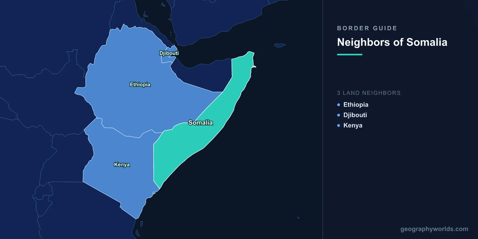
Somalia shares land borders with three countries: Ethiopia to the west, Djibouti to the north-west, and Kenya to the south-west. Those three lines total roughly 2,340 kilometres, and the coastline beyond them — about 3,300 kilometres along the Gulf of Aden and the Indian Ocean — is the longest of any country in mainland Africa. Every one of the three land borders was drawn by European powers across a single ethnic and linguistic population, and that fact has driven Somali politics since independence.
Five Points, Two of Them at Home
The white star on the Somali flag, adopted in 1954, has five points, and each was understood to represent a Somali-inhabited territory. Two of them united in 1960 to form the Somali Republic: the former British Somaliland in the north and Italian Somalia in the south, which merged within days of each becoming independent. The remaining three were French Somaliland, now Djibouti; the Ogaden, inside Ethiopia; and the Northern Frontier District of Kenya.
Greater Somalia — the project of uniting all five — was written into the constitution of the new republic as a national aspiration, and the state pursued it in earnest. That made Somalia unique in post-colonial Africa. Where almost every other new state signed up to the principle that inherited colonial boundaries were inviolable, Somalia's founding purpose was to change three of them.
This is why the Organisation of African Unity's 1964 Cairo resolution on respecting existing borders was, in part, aimed at Mogadishu. Somalia was one of the very few members to dissent.
The Ogaden
The Ogaden is a large, arid, Somali-inhabited region of eastern Ethiopia, now the Somali Region. Britain transferred it to Ethiopian administration in stages after the Second World War, and Somali nationalists never accepted the transfer.
In July 1977, with Ethiopia in revolutionary chaos after the fall of Haile Selassie, Siad Barre invaded. Somali forces initially advanced far into the region and took Jijiga, and for several months it appeared the war might be won. Then the Soviet Union, which had armed Somalia, switched sides to back the new Ethiopian government, and a massive airlift of Soviet equipment and around 15,000 Cuban troops reversed the campaign. Somalia was defeated by March 1978.
The consequences were foundational. The defeat destroyed the credibility of Barre's regime and triggered the clan-based insurgencies that eventually destroyed the Somali state in 1991. It also produced hundreds of thousands of refugees moving east across the border, and it soured Somali-Ethiopian relations for a generation.
The Northern Frontier District
The Kenyan border encloses a second Somali-majority territory. Before Kenyan independence, Britain conducted a commission of inquiry in the Northern Frontier District which found that its overwhelmingly Somali population wanted to join Somalia. Britain handed it to Kenya anyway in 1963, judging that partitioning the new state at birth was the greater risk.
Somalia broke off relations with Britain in protest, and a guerrilla campaign followed — the Shifta War, from 1963 to 1967, fought by Somali separatists against Kenyan forces. Kenya's counter-insurgency involved forced villagisation, confiscation of livestock and heavy restrictions on movement, and the north-east was left underdeveloped for decades afterwards in ways still visible today.
The insurgency ended with a negotiated settlement and Somalia's effective abandonment of the claim, but the region's marginalisation remained, and it is part of the reason the area has been fertile ground for al-Shabaab recruitment fifty years later.
Djibouti, the Somali State That Is Not Somalia
Djibouti is the fifth point that went its own way. Its population is predominantly Somali — chiefly of the Issa clan — with a substantial Afar minority, and Somali irredentists expected it to join after French rule ended.
It became independent in 1977, kept a French military presence, and chose its own course, balancing between its far larger neighbours. The border with Somalia is the shortest of the three, around 60 kilometres, running through the arid country behind the Gulf of Aden coast.
Djibouti has since played a consistently constructive role in Somali affairs, hosting reconciliation conferences — the 2000 Arta conference and the 2008-09 talks that produced a transitional government — and contributing troops to the African Union mission. Its own economy is built on being Ethiopia's port rather than on anything to do with Somalia.
A Border Nobody Recognises
The most consequential boundary in the Somali territories appears on almost no international map. Somaliland, the former British protectorate, declared independence from the rest of Somalia in 1991 after the collapse of the Barre regime, reverting to the borders of the pre-1960 protectorate.
It has held elections, issued its own currency and passports, maintained relative stability and avoided the worst of the violence to the south — and it has not been recognised by a single state. Its claimed frontier with Puntland, over the Sool and Sanaag regions, is disputed and has produced repeated fighting, because Somaliland claims them on colonial-boundary grounds while Puntland claims them on clan grounds.
The result is that the Horn contains a functioning de facto state whose borders have no legal existence, next to a legally recognised state that for decades did not function.
A Port Deal That Nearly Caused a War
In January 2024, Ethiopia and Somaliland announced a memorandum under which Ethiopia would lease around 20 kilometres of coastline near Berbera for a naval and commercial facility, with Ethiopia reportedly offering recognition of Somaliland in return.
Mogadishu treated it as an act of aggression against its territorial integrity, expelled the Ethiopian ambassador and threatened to remove Ethiopian troops from the African Union force. Egypt, in dispute with Ethiopia over the Nile, offered Somalia military support. For several months the Horn looked close to a wider confrontation.
It was defused in December 2024 by the Ankara Declaration, brokered by Turkey, under which Ethiopia acknowledged Somali sovereignty and the two agreed to negotiate commercial sea access. The episode showed how directly a landlocked state's need for a port can destabilise a region — and how much leverage a 3,300-kilometre coastline gives a country that otherwise has little.
Al-Shabaab Crosses the Kenyan Line
Kenya sent troops into southern Somalia in 2011, later folding them into the African Union mission, after a series of kidnappings on its coast. Al-Shabaab's response was to attack inside Kenya.
The Westgate shopping mall siege in Nairobi in 2013 killed 67 people; the assault on Garissa University College in 2015 killed 148, most of them students; and there have been repeated attacks on buses, police posts and villages in the north-east, frequently separating victims by religion.
Kenya began constructing a security barrier along parts of the border in 2015. Progress has been slow and the structure covers only a fraction of the 680-kilometre line, which runs through country where the same communities live on both sides and cross daily.
Dadaab
Just inside the Kenyan border sits Dadaab, established in 1991 for people fleeing the collapse of the Somali state and for years among the largest refugee complexes in the world, at points holding well over 300,000 people.
Children have been born, raised and had children of their own there. Kenya has announced its closure several times — after Westgate, after Garissa, and again subsequently — each time citing security, and each time the order has been delayed, litigated or reversed.
The camp is the most visible consequence of the border: a Somali city of a size that would make it one of Kenya's largest, held in legal suspension a few dozen kilometres from the line.
The Maritime Case Kenya Rejected
Somalia and Kenya disputed a triangle of ocean roughly 100,000 square kilometres in extent, with potential oil and gas. Kenya argued the boundary should run along a line of latitude; Somalia argued for a line perpendicular to the coast, consistent with standard practice.
Somalia took the case to the International Court of Justice, which ruled in October 2021 substantially in Somalia's favour, adopting an equidistance line close to the Somali position. Kenya announced in advance that it would not recognise the court's jurisdiction and rejected the judgment.
Set against the Bakassi and Aouzou cases, where losing states complied, the Kenyan refusal is the counter-example — and a reminder that international adjudication of borders works only when the parties decide it does.
What a Border Means Without a State
For most of the period between 1991 and the mid-2000s, Somalia had internationally recognised borders and no government capable of administering them. Customs, immigration and coastguard functions simply did not exist, and the consequences were exported: illegal fishing by foreign trawlers in Somali waters, waste dumping off the coast, and eventually the piracy that made the Gulf of Aden a global security problem by 2008.
Federal state-building since has produced a patchwork — Puntland, Jubaland, Galmudug, Hirshabelle, South West — whose internal boundaries and relationships with Mogadishu are contested, and whose disputes are frequently more consequential than the international frontiers. Jubaland, on the Kenyan border, has had its own relationship with Nairobi at points when Mogadishu did not.
Three land borders, five points on a flag, and a set of internal lines nobody agreed: that is the geography Somali politics has been arguing about since 1960. Our Somalia country guide takes the country as a whole; for the neighbourhood in context see our Horn of Africa guide, and for the placement question, which continent Somalia belongs to.
