
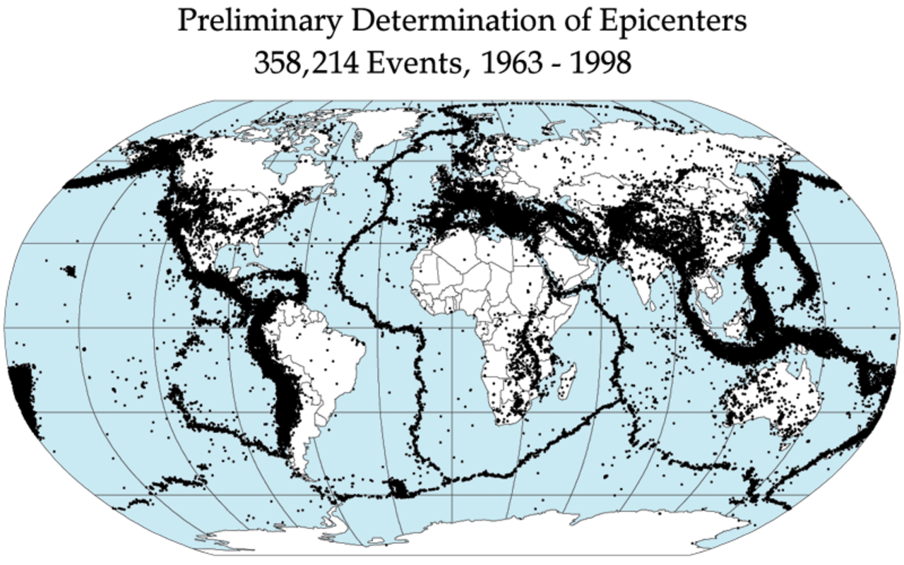
Earth experiences approximately 500,000 detectable earthquakes every year, of which about 100,000 can be felt and roughly 100 cause damage. These earthquakes are not randomly scattered across the globe — they concentrate along narrow belts that trace the boundaries of Earth's tectonic plates. Understanding earthquake belts is fundamental to assessing seismic risk and preparing for the next major quake.
Introduction
The largest earthquake belt is the Circum-Pacific Belt, commonly known as the Ring of Fire, which accounts for approximately 81 percent of the world's largest earthquakes. The second major belt is the Alpide Belt, stretching from the Mediterranean through the Himalayas to Southeast Asia, responsible for about 17 percent of major seismic events.

The Circum-Pacific Belt (Ring of Fire)
- Share of Global Earthquakes: ~81% of the world's largest earthquakes
- Length: ~40,000 km around the Pacific Ocean
- Plate Boundaries: Pacific, Philippine, Nazca, Cocos, Juan de Fuca plates
- Notable Quakes: 1960 Chile (9.5), 2011 Japan (9.1), 1964 Alaska (9.2)
The Ring of Fire is a horseshoe-shaped belt of intense seismic and volcanic activity encircling the Pacific Ocean. It runs from New Zealand northward through Tonga, Japan, and the Aleutian Islands, then southward along the west coast of the Americas from Alaska to Chile. This belt is defined by subduction zones — where dense oceanic plates dive beneath lighter continental plates — generating the most powerful earthquakes on Earth.
The three largest earthquakes ever recorded all occurred along the Ring of Fire: the 1960 Great Chilean Earthquake (magnitude 9.5), the 1964 Great Alaska Earthquake (9.2), and the 2011 Tohoku Earthquake off Japan (9.1). Subduction zones can accumulate centuries of strain before releasing it in seconds, producing megathrust earthquakes that generate devastating tsunamis.
The Alpide Belt
- Route: Mediterranean → Turkey → Iran → Himalayas → Southeast Asia
- Share of Earthquakes: ~17% of the world's largest earthquakes
- Driving Force: Collision of African, Arabian, and Indian plates with Eurasian plate
- Notable Quakes: 2005 Kashmir (7.6), 2023 Turkey-Syria (7.8), 1755 Lisbon (~8.5)
The Alpide Belt stretches approximately 15,000 km from the Azores through the Mediterranean, across Turkey and Iran, through the Himalayas, and into Myanmar and Indonesia. This belt is driven by the collision of the African, Arabian, and Indian tectonic plates with the Eurasian plate — the same forces that built the Alps, the Zagros Mountains, and the Himalayas.
Turkey sits at one of the most complex segments of the Alpide Belt, where the Anatolian plate is being squeezed westward between the converging Arabian and Eurasian plates. The devastating February 2023 earthquakes in Turkey and Syria (magnitude 7.8 and 7.5) killed over 59,000 people and displaced millions, demonstrating the lethal potential of the Alpide Belt's seismicity.
Mid-Ocean Ridge Earthquakes
- Location: Atlantic, Indian, and Pacific ocean ridges
- Magnitude: Typically less than 7.0
- Type: Divergent plate boundaries (plates pulling apart)
- Example: Mid-Atlantic Ridge through Iceland
The global mid-ocean ridge system is the longest mountain chain on Earth, stretching over 65,000 km across the ocean floors. Where tectonic plates pull apart along these ridges, earthquakes occur as new crust forms from upwelling magma. These earthquakes are generally smaller than those at subduction zones, rarely exceeding magnitude 7.0.
Iceland is the most visible example of mid-ocean ridge seismicity, as the Mid-Atlantic Ridge passes directly through the island. Iceland experiences thousands of earthquakes annually, with occasional damaging events. The 2000 South Iceland earthquake sequence included two magnitude 6.5+ events that caused significant damage in the Hella and Selfoss regions.
Intraplate Earthquakes
- Definition: Earthquakes occurring away from plate boundaries
- Examples: New Madrid (US), Bhuj (India), Basel (Switzerland)
- Hazard: Often less prepared communities, amplified shaking
- Mystery: Mechanisms still debated by seismologists
While most earthquakes occur at plate boundaries, some of the most surprising and dangerous strike in the interior of tectonic plates. The New Madrid Seismic Zone in the central United States produced a series of magnitude 7-8 earthquakes in 1811-1812 that rang church bells in Boston and temporarily reversed the flow of the Mississippi River. The area remains seismically active, and a repeat event could devastate Memphis, St. Louis, and Nashville.
The 2001 Bhuj earthquake in Gujarat, India (magnitude 7.7) killed over 20,000 people in an area far from any plate boundary. Intraplate earthquakes are particularly dangerous because they occur in regions with limited seismic building codes and populations unaccustomed to earthquake risk. Their causes remain debated, with explanations including ancient fault reactivation, stress transfer from distant plate boundaries, and glacial rebound.
Seismic Hazard and Preparedness
- Most At-Risk Cities: Tokyo, Istanbul, Tehran, Manila, Mexico City, Lima
- Building Codes: Japan and Chile lead in earthquake-resistant design
- Early Warning: Japan's system provides 5-30 seconds before shaking arrives
- Prediction: No reliable earthquake prediction method exists
Despite decades of research, scientists cannot predict the exact time, location, and magnitude of future earthquakes. However, seismic hazard maps based on fault mapping, historical earthquake catalogs, and GPS measurements allow probabilistic assessment of earthquake risk. Tokyo, Istanbul, Tehran, Lima, and Mexico City consistently rank among the most earthquake-threatened major cities in the world.
Japan leads the world in earthquake preparedness, with strict building codes, nationwide early warning systems, and regular disaster drills. The country's earthquake early warning system detected the 2011 Tohoku earthquake and broadcast alerts up to 30 seconds before strong shaking reached Tokyo, giving residents precious time to take cover. Chile, another seismically advanced nation, saw relatively low casualties from its magnitude 8.8 earthquake in 2010 thanks to rigorous building standards.
Key Facts
- The Ring of Fire accounts for approximately 81% of the world's largest earthquakes.
- The three strongest earthquakes ever recorded occurred along the Ring of Fire (Chile 9.5, Alaska 9.2, Japan 9.1).
- The Alpide Belt from the Mediterranean to Southeast Asia produces about 17% of major earthquakes.
- Earth experiences roughly 500,000 detectable earthquakes per year.
- No reliable method for predicting specific earthquakes currently exists.
Fun Facts
- The 1960 Chilean earthquake was so powerful that it caused a tsunami that killed 61 people in Hawaii and 199 in Japan — over 10,000 km away.
- The New Madrid earthquakes of 1811-1812 in Missouri were felt across an area of approximately 5 million square kilometers.
- Tokyo has a roughly 70% probability of experiencing a magnitude 7+ earthquake within the next 30 years, according to Japanese government estimates.
- Moonquakes — seismic events on the Moon — were first detected by instruments left by Apollo astronauts.
Final Thoughts
Earth's earthquake belts are a direct consequence of plate tectonics, the engine that drives our planet's geology. From the Ring of Fire to the Alpide Belt to unexpected intraplate events, understanding where earthquakes concentrate — and why — is essential for building resilient communities and saving lives in the next great seismic event.
Test Your Knowledge!
Think you know the world's extreme weather?
Play Geography Games →