
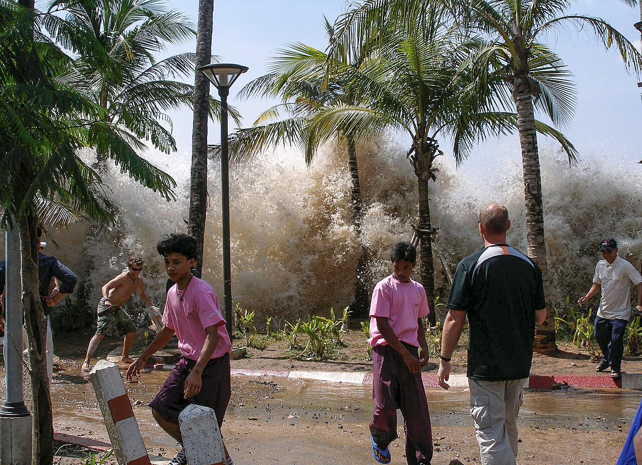
Tsunamis form when a large volume of ocean water is suddenly displaced, most commonly by a powerful underwater earthquake that shifts the seafloor. The displaced water generates waves that radiate outward in all directions at speeds up to 800 kilometers per hour in deep ocean, slowing and growing dramatically in height as they approach shallow coastal waters.
Introduction
The word "tsunami" comes from Japanese, meaning "harbor wave." Unlike wind-generated waves that affect only the surface, tsunami waves involve the entire water column from surface to seafloor, giving them enormous energy. A tsunami that is barely noticeable in the open ocean can grow to 30 meters or more as it reaches shore, devastating coastal communities.

The Short Answer
- Primary Cause: Underwater earthquakes displacing the seafloor
- Also Caused By: Submarine landslides, volcanic eruptions, asteroid impacts
- Speed: Up to 800 km/h in deep ocean (speed of a jet plane)
When an earthquake occurs beneath the ocean, the sudden vertical displacement of the seafloor pushes the entire water column above it upward or drops it downward. This creates a disturbance that propagates outward as a series of waves. The amount of water displaced can be enormous: the 2004 Indian Ocean earthquake lifted the seafloor by up to 15 meters along a 1,300-kilometer rupture.
Only certain types of earthquakes generate tsunamis. The earthquake must be shallow (typically less than 100 km deep), powerful (usually magnitude 7.0 or greater), and must involve vertical displacement of the seafloor. Strike-slip earthquakes, where plates slide horizontally past each other, generally do not produce significant tsunamis because they don't displace the water column vertically.
The Science Behind It
- Deep Ocean: Wave height < 1 m, wavelength 100-200 km
- Shallow Water: Waves slow, compress, and grow to 10-30+ m
- Wave Period: 10-60 minutes between successive waves
- Run-Up: Maximum height tsunami reaches onshore
In the deep ocean, a tsunami wave may be only 30-60 centimeters high, with a wavelength of 100 to 200 kilometers. At these scales, ships at sea barely notice the wave passing beneath them. However, the wave carries tremendous energy through the entire depth of the water column.
As the tsunami enters shallow coastal waters, the front of the wave slows while the back continues at deep-water speed. The wave compresses, the wavelength shortens, and the wave height increases dramatically, a process called shoaling. A barely perceptible deep-ocean wave can grow to 10, 20, or even 30+ meters at the coast. The first sign is often a dramatic withdrawal of the sea, as the trough of the wave arrives before the crest, exposing the seafloor.
Types & Variations
- Tectonic Tsunamis: Generated by seafloor earthquakes (most common and largest)
- Volcanic Tsunamis: Caused by eruptions, caldera collapse, or pyroclastic flows
- Landslide Tsunamis: Triggered by submarine or coastal landslides
- Meteotsunamis: Generated by rapid atmospheric pressure changes
Volcanic tsunamis can be devastating but are less common than tectonic ones. The 2022 Hunga Tonga eruption generated a tsunami that affected coastlines across the Pacific. The 1883 Krakatoa eruption produced waves over 30 meters high that killed approximately 36,000 people.
Landslide-generated tsunamis can produce the tallest waves of all, but over limited areas. In 1958, a landslide in Lituya Bay, Alaska triggered a local tsunami that reached 524 meters up the opposite shore, the tallest wave ever recorded. Submarine landslides can also generate tsunamis; the Storegga Slide off Norway approximately 8,000 years ago created waves that struck Scotland and Norway.
Famous Examples
- 2004 Indian Ocean: ~230,000 killed across 14 countries
- 2011 Tohoku, Japan: Run-up heights up to 40 m, triggered Fukushima disaster
- 1960 Chile: Tsunami crossed the Pacific, causing damage in Hawaii and Japan
- 1883 Krakatoa: Volcanic tsunami killed ~36,000 in Indonesia
The 2004 Indian Ocean tsunami was generated by a magnitude 9.1 earthquake off the coast of Sumatra. Waves traveled across the entire Indian Ocean, reaching East Africa over 7 hours later. In Banda Aceh, Indonesia, the closest major city to the epicenter, waves over 30 meters high swept up to 5 kilometers inland, killing over 160,000 people in Indonesia alone. There was no tsunami warning system in the Indian Ocean at the time.
The 2011 Tohoku tsunami in Japan overwhelmed seawalls designed for smaller waves, with run-up heights reaching 40 meters in some locations. The waves traveled up to 10 kilometers inland, destroying entire towns and triggering the Fukushima Daiichi nuclear disaster. Japan's advanced early warning system provided 8-30 minutes of warning, saving many lives, but the tsunami exceeded all design parameters.
Why It Matters
- Warning Systems: Pacific Tsunami Warning Center monitors the entire Pacific basin
- Coastal Planning: Tsunami hazard zones guide building codes and evacuation routes
- Preparedness: Education and drills can dramatically reduce casualties
Since the 2004 Indian Ocean disaster, tsunami warning systems have been expanded to cover all ocean basins. The Deep-ocean Assessment and Reporting of Tsunamis (DART) network uses seafloor sensors to detect tsunami waves in real time and relay data via satellite to warning centers. Warning times range from minutes for nearby coasts to hours for distant shores.
Community preparedness is equally critical. In Japan, regular tsunami drills, elevated evacuation routes, and public education have saved thousands of lives. The phrase "tendenko" (each person, save yourself) teaches people not to wait for family members but to immediately run to high ground. Natural warning signs, such as strong ground shaking, unusual sea withdrawal, or a roaring sound from the ocean, should trigger immediate evacuation.
Key Facts
- Tsunamis can travel at up to 800 km/h in deep ocean, as fast as a commercial jet.
- The 2004 Indian Ocean tsunami killed approximately 230,000 people, the deadliest in recorded history.
- A tsunami wave in deep ocean may be less than 1 meter high but carry enormous energy.
- The first warning sign is often a dramatic withdrawal of the sea, exposing the seafloor.
- The tallest tsunami wave ever recorded was 524 meters, caused by a landslide in Lituya Bay, Alaska in 1958.
Fun Facts
- Tsunami waves can travel the entire width of the Pacific Ocean in less than 24 hours.
- The 1960 Chilean tsunami took 22 hours to reach Japan, where it still killed 142 people.
- Ancient deposits of tsunami sand have been found far inland on many coastlines, recording prehistoric events.
- Some species of animals reportedly fled to higher ground before the 2004 tsunami, though the science behind this remains debated.
Final Thoughts
Tsunamis are among the most terrifying and destructive natural phenomena on Earth, transforming an invisible deep-ocean wave into a wall of water that can devastate coastlines thousands of kilometers from its source. Understanding how tsunamis form has enabled the development of warning systems that save lives, but the fundamental threat remains. With hundreds of millions of people living in tsunami-prone coastal areas, preparedness, education, and respect for the power of the ocean are our best defenses.
Test Your Knowledge!
Curious about geography? Test what you've learned!
Play Geography Games →