

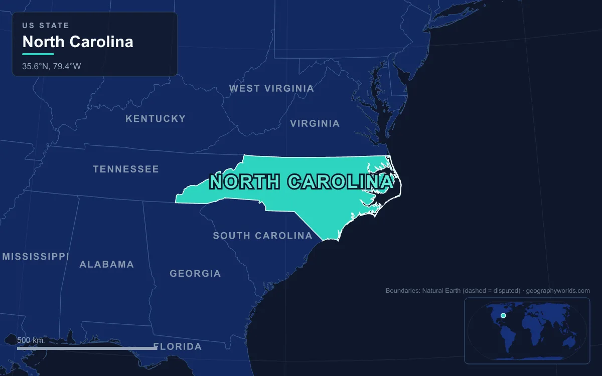
North Carolina’s landforms fall into three belts that run parallel to the coast: the Appalachian Mountains in the west, including the Blue Ridge, the Great Smokies and the Black Mountains, where Mount Mitchell rises to 2,037 m (6,684 ft), the highest point in the United States east of the Mississippi; the rolling Piedmont plateau in the middle, 90 to 340 m (300 to 1,100 ft) high; and the flat Atlantic Coastal Plain in the east, which covers about 45% of the state and ends in the barrier islands of the Outer Banks, where the land meets sea level. The state covers 139,391 km² (53,819 sq mi) and is about 810 km (503 mi) long. One road crosses all three belts. US 64 is the longest numbered route in North Carolina, running 972 km (604 mi) from the Tennessee line past Murphy to the Outer Banks past Manteo, which is why “from Murphy to Manteo” is shorthand for the whole state. Driving it west to east is a tour of how the land steps down to the sea.
Mile zero: Murphy and the Hiwassee valley
US 64 enters North Carolina in Cherokee County and reaches Murphy almost at once. The town sits at the confluence of the Hiwassee and Valley rivers, in a basin enclosed by forested ridges, and it is the westernmost county seat in the state, roughly 580 km (360 mi) from Raleigh. The Hiwassee flows west, away from the Atlantic, toward the Tennessee River, because Murphy lies on the far side of the Eastern Continental Divide.
From Hayesville to Franklin, 56 km (35 mi) of the highway doubles as Corridor A of the Appalachian Development Highway System, one of the federally funded roads built to open up the mountain counties. Here the landscape is a chain of valleys and ridges in the Nantahala National Forest, with the road threading between them rather than over them.
Highlands and the Cullasaja River Gorge
East of Franklin the road climbs onto the Highlands Plateau, and the segment from Franklin to Highlands is steep enough that large trucks are sent the long way round via Sylva and Asheville. Highlands itself stands at an official average elevation of 1,255 m (4,118 ft), one of the highest incorporated towns east of the Mississippi, and it straddles the Eastern Continental Divide. That elevation wrings rain out of storms moving up from the lowlands: Highlands averages about 2,224 mm (87.6 in) a year.
All that water has to come off the plateau somewhere, and on the way down to Franklin US 64 follows the Cullasaja River through a gorge lined with waterfalls. Along a 14 km (8.7 mi) stretch of river the falls come in sequence. Dry Falls, 23 m (75 ft) high, pours over an overhanging bluff; the rock shelter behind it stays dry when the flow is low, which gave the falls its name. Farther down, Cullasaja Falls, the last major fall on the river, is a long cascade over about 300 m of channel, variously measured at 61 to 77 m (200 to 250 ft). It sits beside a series of blind curves on the highway with sheer rock above, so most drivers see it only in a glimpse.

Down the Blue Ridge Escarpment through Hickory Nut Gorge
Past Brevard and Hendersonville, US 64 drops off the mountains through Bat Cave, Chimney Rock and Lake Lure. This is the Blue Ridge Escarpment, the steep eastern face of the mountains where they drop to the Piedmont. Hickory Nut Gorge, the narrow valley the road follows, was cut by the Broad River. Its walls are Henderson Gneiss, a coarse augen gneiss that began as granite about 509 million years ago and was later metamorphosed. The rock is massive and largely unfractured, which is why it stands in cliffs; where erosion has worked along its joints it has left free-standing towers and talus caves such as Bat Cave.
Chimney Rock State Park protects the gorge’s landmarks. The Chimney is a gneiss monolith 96 m (315 ft) tall, carved by erosion along joints in the Henderson Gneiss, and Hickory Nut Falls drops 123 m (404 ft) nearby. The gorge’s floor was flooded deliberately in the 1920s: in 1925 the Morse family, which had bought Chimney Rock in 1902, set up a power company to dam the Broad River, and the full impoundment of Lake Lure was completed in 1927. It covers about 290 hectares (720 acres) with 43 km (27 mi) of shoreline. The same river showed its power in September 2024, when more than 480 mm (19 in) of rain from Hurricane Helene fell upstream; the flood destroyed half of the village of Chimney Rock and overtopped the Lake Lure dam. A narrow gorge funnels water as efficiently as it funnels a road.
Brushy Mountains and Uwharries: old peaks in the Piedmont
Beyond Forest City the road turns north to Morganton, crosses I-40 for the first time, and runs through Lenoir. The ridge on Lenoir’s edge is Hibriten Mountain, where the Brushy Mountains begin. The Brushies are an isolated spur of the Blue Ridge, cut off from it by the Yadkin River valley, and run about 72 km (45 mi) northeast across Caldwell, Alexander, Wilkes, Iredell and Yadkin counties while dividing the waters of the Catawba River from the Yadkin. The range is only 6 to 13 km (4 to 8 mi) wide and usually rises 90 to 240 m (300 to 800 ft) above the surrounding countryside; the highest summit, Pores Knob in Wilkes County, reaches 817 m (2,680 ft).
East of Statesville and Mocksville, US 64 swings south of the Piedmont Triad cities to Asheboro, on the edge of the Uwharrie Mountains. These are North Carolina’s easternmost and lowest range, topping out at High Rock Mountain, only 341 m (1,119 ft), though they still stand several hundred feet above surrounding land that averages about 150 m (500 ft). They are also among its most unusual. The Uwharries are the eroded stumps of a volcanic island arc: zircon dating puts their volcanism at roughly 570 to 550 million years ago, and welded tuffs in the range record violent explosive eruptions. The arc belonged to the Carolina terrane, a microcontinent that later docked against ancestral North America, probably in the Middle Ordovician, between about 465 and 455 million years ago.
Jordan Lake and the fall line at Raleigh and Rocky Mount
Through Siler City and Pittsboro the road crosses B. Everett Jordan Lake at Wilsonville. The reservoir was built by the Army Corps of Engineers on the Haw and New Hope rivers after a destructive 1945 tropical storm; the dam was finished in 1974, and at its standard level of 66 m (216 ft) above sea level the lake covers about 5,640 hectares (13,940 acres) with 290 km (180 mi) of shoreline.
At Raleigh the route meets the fall line, the most important boundary most drivers never notice. It separates the hard metamorphic and igneous rock of the Piedmont from the soft sediments of the Coastal Plain, and it runs through Fayetteville, Raleigh and Henderson. The land drops 46 to 107 m (150 to 350 ft) eastward across it, spread over 1.6 to 4.8 km, and rivers break into rapids where they cross. Those rapids decided where towns grew. Rocky Mount, which US 64 reaches by freeway, began at the falls of the Tar River: boats could navigate downstream to the coast, and the drop powered the textile mills that built the town after its incorporation in 1867.
Pocosins and swamps on the Alligator River
East of Tarboro the land flattens into the Coastal Plain proper. At Williamston US 64 crosses the Roanoke River, then runs on to Plymouth and Columbia, and from Columbia it is a two-lane road through the swamps of Tyrrell County. The rivers here are wider, deeper and slower than anything upstream, and the sandy soils suit tobacco, cotton and soybeans.
The flattest landform on the whole route is also one of the most unusual. The Alligator River National Wildlife Refuge, established in 1984, covers about 615 km² (152,000 acres) of mainland Dare and Hyde counties, and it exists to protect pocosin, a wetland of deep, acidic, sandy peat that stays saturated except in droughts. Pocosins occupy poorly drained higher ground between streams and floodplains rather than river bottoms, and are dominated by pond pine and dense shrubs; they are sometimes called shrub bogs. The majority of pocosins are found in North Carolina. The refuge is bounded by the Alligator River and Intracoastal Waterway on the west, crossed by the 4.5 km (2.8 mi) Lindsay C. Warren Bridge, and by Albemarle Sound to the north.
Roanoke Island, Nags Head and Jockey’s Ridge
At Manns Harbor the road reaches the sounds, the drowned lowland behind the barrier islands. Albemarle Sound, fed by the Chowan and Roanoke rivers, is largely brackish or fresh; Pamlico Sound to the south is larger than the state of Connecticut. Together they are the two largest landlocked sounds in the United States. US 64 crosses Croatan Sound to Roanoke Island, either on the Virginia Dare Memorial Bridge or through Manteo on the older William B. Umstead Bridge, then takes a string of bridges and causeways to Bodie Island on the Outer Banks. It ends at Whalebone Junction in Nags Head.
The Outer Banks are low barrier islands of sand, and storms, strong tides and shoals off them have wrecked so many ships that the coast is called the Graveyard of the Atlantic. The barrier islands and coastal swamps are also why the state, for all its hundreds of kilometres of beach, lacks a good natural harbour. The geography of the Outer Banks covers the capes, Hatteras, Lookout and Fear, in detail.

A few kilometres from the end of the road, at milepost 12 on US 158, is the last landform of the trip: Jockey’s Ridge, the tallest active sand dune system in the eastern United States, protected in a 173-hectare (427-acre) state park. Its main dune is a medano, a large, asymmetric hill of bare sand. Strong northeasterly winter winds outweigh the gentler southwesterly summer winds, so the dunes creep about 0.3 to 1.8 m (1 to 6 ft) to the southwest each year, holding an estimated 30 million tons of sand. After rain, water collects in vernal pools at their base.
From the Hiwassee valley to the Nags Head dunes, US 64 descends from mountains built by colliding microcontinents, across the stumps of an ancient volcanic arc, over the fall line and onto sediment still being shaped by wind. For the mountain chain that anchors the western end of the drive, see the Appalachian Mountains guide, and for the rest of the state, the geography of North Carolina.