
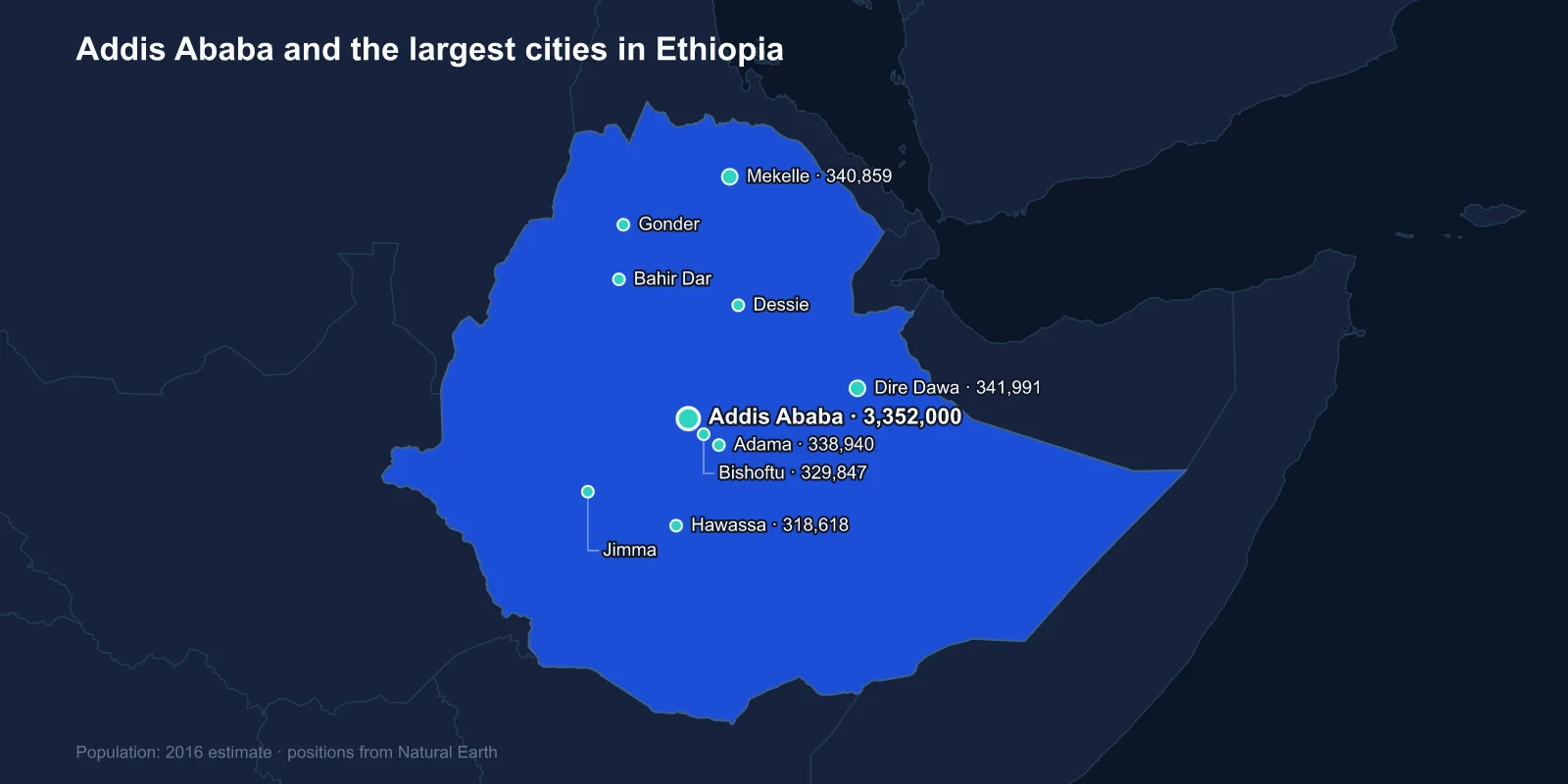
The largest cities in Ethiopia are Addis Ababa (about 3,352,000), Dire Dawa (341,991), Mekelle (340,859), Adama (338,940), Bishoftu (329,847), Hawassa (318,618), Bahir Dar (297,794), Gonder (285,000), Dessie (198,428) and Jimma (186,148). Those are the 2016 official estimates, the most recent comprehensive figures published; Ethiopia's last full census was taken in 2007 and the one scheduled since has been repeatedly postponed.
The ranking has one dominant feature. Addis Ababa is roughly ten times the size of the second city, and larger than the next eight cities put together. Very few countries of 130 million people concentrate their urban life so completely in one place.
A Capital That Is Younger Than the Railway
Addis Ababa was founded in 1886, which makes it younger than Chicago's skyscrapers and almost the same age as the Eiffel Tower. Emperor Menelik II had been campaigning from a series of mobile camps, and it was his wife, Empress Taytu Betul, who chose the hot springs at Filwoha as a permanent site and gave the place its name: Addis Ababa, new flower.
The settlement nearly failed within fifteen years. A camp of that size burned wood faster than the surrounding hills could grow it, and by 1900 the court was preparing to move west to a new site at Addis Alem. What saved the capital was a botanical import — fast-growing eucalyptus from Australia, planted on a large scale from about 1895. The trees solved the fuel problem and the move was abandoned. Ethiopia's capital exists where it does because of a species that is not native to the continent.
The city sits at roughly 2,355 metres, among the highest capitals anywhere. The altitude gives it a temperate climate on the ninth parallel, which is why it never developed the tropical lowland diseases that shaped colonial settlement patterns elsewhere in Africa.
The Diplomatic Argument for Its Size
Addis Ababa's population is not explained by industry. It is explained by institutions. The city hosts the headquarters of the African Union, which inherited the site from the Organisation of African Unity founded there in 1963, and the United Nations Economic Commission for Africa, which arrived in 1958.
More than a hundred countries maintain embassies in the city, and it is routinely described as the diplomatic capital of Africa — a status that generates hotels, conference facilities, translation services, international schools and an airline hub, none of which would exist at this scale in a city of its economic size. Ethiopian Airlines built Bole International into the continent's busiest passenger hub partly on the strength of that traffic.
In 2015 the city opened a light rail system, the first in sub-Saharan Africa, built with Chinese finance and running on two lines through the centre. It was a statement about what the government expected the city to become.
Dire Dawa Exists Because a Train Would Not Climb
Second place belongs to a city that was created by an engineering decision. Dire Dawa was founded in 1902 as a station on the Franco-Ethiopian railway from Djibouti, and it was sited there because the line could not be taken up the escarpment to Harar, the ancient walled city forty-odd kilometres away.
Harar was the established centre — a UNESCO-listed walled town of eighty-two mosques, a trading city with its own emirate and its own language. The railway bypassed it, and within a few decades the upstart at the bottom of the hill was several times its size. Dire Dawa today is one of two chartered cities that sit outside the regional state structure, the other being Addis Ababa itself.
The Regional Capitals, and Why They Cluster in Size
Positions three through eight are occupied by cities separated by remarkably little. Mekelle, Adama, Bishoftu, Hawassa, Bahir Dar and Gonder all fall between roughly 285,000 and 341,000. This is not coincidence: most are regional or zonal administrative seats, and their size reflects the machinery of government, a university, a hospital and a market rather than any particular industry.
Mekelle is the capital of Tigray and was the centre of the war fought between 2020 and 2022; its population figures from the 2016 estimate predate a conflict that displaced people on an enormous scale, and no reliable replacement count exists.
Adama, still widely called Nazret, sits on the road and rail corridor to Djibouti and briefly served as the capital of Oromia between 2000 and 2005 before the regional government moved back to Addis Ababa. Bishoftu, formerly Debre Zeit, is built among a cluster of volcanic crater lakes and hosts the air force's main base. Hawassa lies on the lake of the same name and was chosen for one of the country's flagship industrial parks, aimed at garment manufacturing for export.
Bahir Dar stands where the Blue Nile leaves Lake Tana, a position that has made it both a tourism centre and the obvious site for hydroelectric interest. Gonder was the imperial capital from the 1630s until the mid-nineteenth century, and its castle compound at Fasil Ghebbi is the reason most visitors go — a walled royal enclosure that looks, improbably, like a European fortress on the Ethiopian highlands.
Coffee, Salt and the Towns Below the Top Ten
Ninth and tenth place go to two towns that explain a good deal about Ethiopian trade. Dessie grew up on the northern highway as a staging post between the highlands and the coast, a market town for Wollo that swelled and shrank with each drought and each war along the route.
Jimma, at the other end of the country, sits in the forested south-west where Coffea arabica grows wild. The genetic homeland of arabica coffee is the Kaffa region beside it, and the word coffee itself is usually traced to that name. Jimma was the seat of an independent Oromo kingdom until 1932 and remains the commercial centre of a region that supplies a crop accounting for a substantial share of Ethiopia's export earnings.
Just below the cut sit Jijiga, the capital of the Somali region out on the eastern lowlands, and Shashamane, a junction town in Oromia best known internationally for the land granted by Haile Selassie in 1948 to members of the Rastafari movement, several hundred of whom settled there.
Why the Numbers Are Older Than You Would Expect
Every figure in this ranking carries an asterisk, and it is worth understanding why. Ethiopia has conducted three modern censuses — 1984, 1994 and 2007. A fourth was scheduled for 2017, postponed to 2018, postponed again to 2019, and then shelved indefinitely amid unrest, the Tigray war and disputes over what a recount would mean for regional representation.
Because seats in the federal parliament and the allocation of budget transfers both depend on population, a census in Ethiopia is not a neutral statistical exercise. Counting people redistributes power, which is precisely why it keeps not happening.
The practical result is that the best available comprehensive figures are 2016 projections built forward from a 2007 base. They are internally consistent, which is what makes them useful for ranking cities against one another, but they are close to a decade old and they predate both the Tigray conflict and the fastest years of Addis Ababa's construction boom. Treat the order as reliable and the absolute numbers as conservative.
The Country Is Far Less Urban Than the List Suggests
A ranking of cities can make a country look urbanised. Ethiopia is not. Somewhere around a fifth to a quarter of the population lives in towns, one of the lowest proportions in the world, and the great majority of Ethiopians live in rural highland farming communities growing teff, barley, wheat and enset.
That has two consequences for the list. First, the absolute numbers are small relative to the national population: the ten largest cities together hold well under a tenth of the country. Second, the figures move quickly, because rural-to-urban migration is running at a rate that makes any estimate several years old unreliable. Current projections put Addis Ababa well above four million, and some estimates of the wider built-up area go considerably higher.
A City With No Region
Addis Ababa's constitutional position is unusual and politically live. It is a chartered city answering to the federal government, but it sits entirely inside Oromia, and the Oromo have a long-standing claim to it as Finfinne, their historic land.
In 2014 a proposed master plan to extend municipal planning authority into surrounding Oromia districts triggered protests that ran for three years, were met with lethal force, and contributed directly to the political crisis that brought Abiy Ahmed to office in 2018. The plan was withdrawn. The underlying question — who the capital belongs to, and what happens to farmers on its expanding edge — has not been settled.
This is the sharpest illustration of why urban primacy matters here. When one city holds the government, the diplomatic corps, the national airline, the universities and most of the formal economy, the question of who controls its boundaries is not a municipal matter.
What the Ranking Tells You
Read as a whole, Ethiopia's city list describes a country whose urban system is young, highly centralised and administratively rather than industrially driven. The capital is a century and a half old and owes its survival to an imported tree. The second city exists because a railway could not climb a hill. The middle of the table is a row of regional seats of near-identical size, and the ancient centres — Harar, Aksum, Lalibela — are not in the top ten at all.
Gonder’s castles and Lalibela’s rock churches belong to the tradition traced in Ethiopian religious life, and the capital gets a fuller treatment of its own in the Addis Ababa profile. The highlands that hold all of this are the subject of our Ethiopia country guide.
