
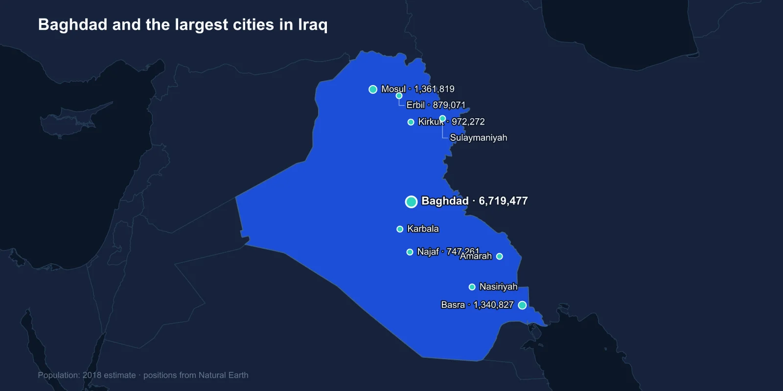
The largest cities in Iraq are Baghdad (about 6,719,477), Mosul (1,361,819), Basra (1,340,827), Kirkuk (972,272), Erbil (879,071), Najaf (747,261), Karbala (711,530), Sulaymaniyah (676,492), Nasiriyah (558,446) and Amarah (527,472). These are 2018 estimates; Iraq's last full census was conducted in 1987, with a partial count in 1997 that excluded the Kurdish region.
The list divides cleanly into three. There is Baghdad, which dwarfs everything. There is the Kurdish north, with Erbil and Sulaymaniyah. And there is the Shia south, including two cities whose size is explained almost entirely by pilgrimage.
A Capital Built as a Perfect Circle
Baghdad was founded in 762 by the Abbasid caliph al-Mansur, and it was laid out as a perfect circle — the Round City, with the palace and mosque at the centre and four gates on the axes. Nothing of that plan survives above ground, but for several centuries the city it produced was probably the largest in the world and the intellectual centre of the age.
The House of Wisdom in Baghdad is where Greek philosophy and Indian mathematics were translated into Arabic and developed, and the transmission of the decimal place-value system into the wider world runs through it. The Mongol sack of 1258 ended that period comprehensively.
Modern Baghdad straddles the Tigris, with Rusafa on the east bank and Karkh on the west. It held roughly a fifth of Iraq's population before 2003 and holds a comparable share now, having absorbed enormous internal displacement during the sectarian violence of 2006 and 2007, which also sorted many of its mixed neighbourhoods into Sunni and Shia ones.
Mosul, and What Was Destroyed There
Mosul sits on the Tigris in the north, across the river from the ruins of Nineveh, the Assyrian capital sacked in 612 BC. It has historically been the most mixed of Iraq's large cities, with Sunni Arab, Kurdish, Turkmen, Assyrian Christian and Yazidi populations.
The Islamic State took Mosul in June 2014 and held it for three years. The battle to retake it, from October 2016 to July 2017, was among the most destructive urban campaigns since the Second World War. The old city west of the river was largely flattened, and the al-Nuri mosque with its leaning minaret — from whose pulpit the caliphate had been declared — was blown up by the retreating fighters in 2017.
Reconstruction has been slow and partial. The minaret and the mosque have been rebuilt under a UNESCO programme, but much of the west bank remains rubble, and Mosul's population figure from 2018 was taken at the very bottom of that curve.
Basra Has the Oil and the Water Problem
Basra is Iraq's only real port city and the centre of its oil industry. The southern fields around it — Rumaila, West Qurna, Majnoon — hold the large majority of national reserves, and essentially all Iraqi crude leaves through terminals in the Gulf below the city.
It is also the city with the most acute environmental crisis in the country. Basra sits at the bottom of the Tigris-Euphrates system, and upstream dams in Turkey, Syria and Iran have reduced the flow to the point that salt water from the Gulf pushes up the Shatt al-Arab. In the summer of 2018 contaminated water sent an estimated 100,000 people to hospital and triggered protests that burned government buildings.
A city sitting on some of the world's largest oil reserves and unable to supply drinkable water to its own residents is the sharpest illustration of Iraq's governance problem.
Two Cities Built Around Tombs
Najaf and Karbala are the sixth and seventh largest cities in Iraq, and neither has a significant industrial base. They are shrine cities.
Najaf holds the tomb of Ali ibn Abi Talib, the cousin and son-in-law of Muhammad and the central figure of Shia Islam. Karbala holds the tomb of his son Husayn, killed there in 680 in the battle that defines Shia identity and is commemorated each year at Ashura. The Arbaeen pilgrimage to Karbala forty days later draws crowds that are regularly estimated in the millions and is among the largest annual gatherings of people anywhere on earth.
Najaf also has the Wadi al-Salam cemetery, which is generally described as the largest cemetery in the world — millions of burials over more than a thousand years, spread across several square kilometres, because devout Shia from across the region have sought burial beside Ali.
The economies of both cities run on hospitality, religious study and the servicing of pilgrims. Najaf's seminary, the hawza, is one of the two great centres of Shia scholarship, and the religious authority based there carries political weight across the country.
The Kurdish North
Erbil and Sulaymaniyah are the two largest cities of the Kurdistan Region, which has had its own government, parliament and armed forces since the 1990s.
Erbil is built around a citadel mound that has been continuously inhabited for perhaps six thousand years, which makes it a candidate for the oldest continuously occupied settlement in the world. The citadel is UNESCO-listed and rises abruptly above the modern city that has grown in rings around it.
Sulaymaniyah, founded much later in 1784, is the region's cultural and literary centre and has a distinct political tradition from Erbil, the two being associated with rival Kurdish parties. Both cities grew rapidly after 2003 as the region attracted investment that the rest of Iraq could not.
Kirkuk, the Contested City
Kirkuk, fourth on the list, sits on a large oil field and on the boundary between Arab, Kurdish and Turkmen Iraq, and its status has been unresolved for a century.
Under the Baath government it was subject to a deliberate Arabisation programme, with Kurdish and Turkmen residents displaced and Arab families settled in their place. Article 140 of the 2005 constitution required a census and referendum to determine whether Kirkuk should join the Kurdistan Region. Neither has ever been held.
Control of the city passed between Iraqi federal forces and Kurdish peshmerga after 2014 and again in 2017. It remains the single most contested piece of urban territory in the country.
The Marsh Cities of the South
Nasiriyah and Amarah sit in the far south near the Mesopotamian marshes, the wetlands at the confluence of the Tigris and Euphrates that were drained in the 1990s as a reprisal against the Marsh Arabs after the 1991 uprising.
Both cities absorbed displaced marsh dwellers during that period, and both have since become centres of protest — Nasiriyah in particular was one of the most persistent sites of the 2019 demonstrations over unemployment and corruption, and among the deadliest.
Nearby Ur, the Sumerian city with its reconstructed ziggurat, sits just outside Nasiriyah, which gives the province a claim to some of the oldest urban remains in the world alongside some of the country's newest political movements.
The marshes themselves have partly recovered since 2003, when local people breached the drainage embankments and water returned to a fraction of the old extent. UNESCO inscribed them in 2016 together with Ur, Uruk and Eridu as a single mixed property, tying the wetlands to the cities they once fed.
Hillah, Diwaniyah and the Euphrates Towns
Below the top ten the list continues down the Euphrates. Hillah sits beside the ruins of Babylon, close enough that the reconstructed Ishtar Gate and Saddam Hussein's palace on the artificial mound above it are effectively suburbs. Diwaniyah and Kut are provincial capitals on the same river system, agricultural market towns supported by irrigation canals that in some cases follow Sumerian alignments.
These cities rarely appear in coverage of Iraq, which tends to concentrate on Baghdad, the north and Basra. They are nonetheless where a large share of the country's population lives, and their grievances — unemployment, electricity, water — drove much of the protest movement that forced a prime minister from office in 2019.
Why There Has Been No Census Since 1987
Iraq has not completed a full national census in more than three decades, and the reason is the same one that blocks a settlement in Kirkuk: counting people determines how seats and budgets are allocated among Sunni Arabs, Shia Arabs, Kurds and minorities.
A census planned repeatedly since 2007 was postponed each time. One was finally conducted in November 2024, the first since 1987, though the detailed results relevant to city-level population had not been fully published when these estimates were compiled.
Until they are, the 2018 figures remain the working baseline, and they should be read as reasonable orderings rather than precise counts.
One further complication is that Iraqi city figures often describe governorates or districts rather than municipal boundaries, and the two can differ by a factor of two. Baghdad governorate holds well over eight million people; the built-up city is smaller. Comparing Iraqi cities with those of other countries therefore requires checking what is actually being counted.
What the Ranking Describes
Iraq's cities sit where the rivers are, and their relative sizes record the country's fault lines: an enormous capital, a northern city still rebuilding from a siege, a southern port that cannot drink its own water, two pilgrimage centres, two Kurdish capitals and one city that everybody claims.
Why Najaf and Karbala are the size they are is a question answered by Iraqi religious life rather than by economics. The Baghdad profile covers the capital in more depth, and the two rivers everything here is built along run through our Iraq country guide.
