
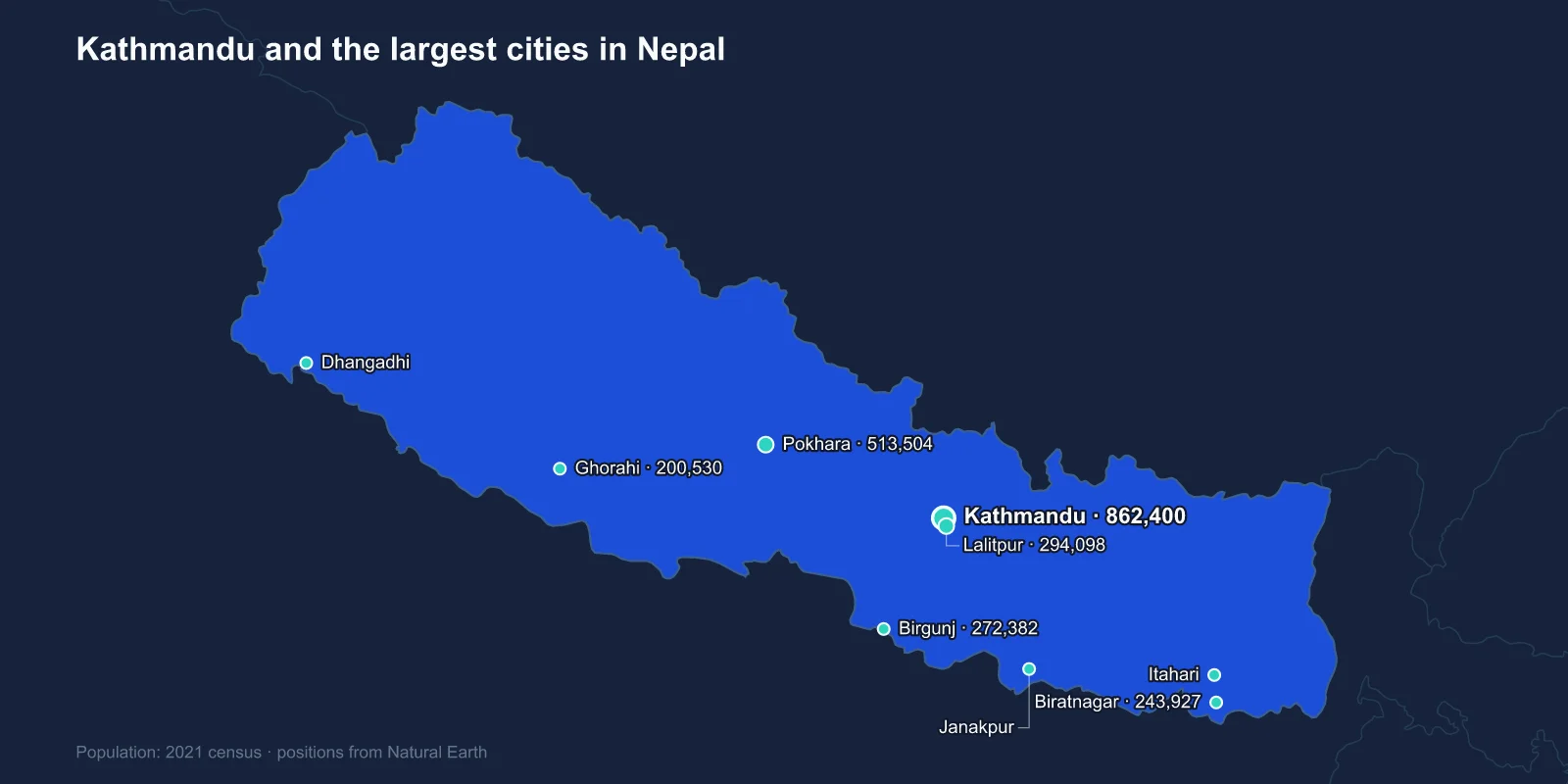
The largest cities in Nepal are Kathmandu (862,400), Pokhara (513,504), Bharatpur (369,268), Lalitpur (294,098), Birgunj (272,382), Biratnagar (243,927), Ghorahi (200,530), Dhangadhi (198,792), Itahari (197,241) and Janakpur (194,556). These are 2021 census figures.
The list contains a surprise for anyone who thinks of Nepal as a mountain country. Apart from Kathmandu, Lalitpur and Pokhara, every city in the top ten sits on the Terai — the flat, hot strip of the Gangetic plain along the Indian border.
The Mountains Are Where People Do Not Live
Nepal divides into three bands running east to west. The high Himalaya in the north holds eight of the world's fourteen peaks above 8,000 metres and almost no population. The middle hills hold the valleys, including Kathmandu's. The Terai in the south, barely above sea level, holds around half the country's people on about a sixth of its area.
That distribution is recent. The Terai was forested and malarial into the twentieth century, and it was largely avoided. A DDT-based eradication programme from the 1950s onwards made it habitable, and hill populations moved down in enormous numbers over the following decades.
The consequence is that Nepal's urban growth has happened almost entirely on the plain, along the east-west highway and at the border crossings into India, while the hills have been losing people to migration for two generations.
Three Cities in One Valley
Kathmandu, Lalitpur and Bhaktapur sit within a few kilometres of each other in a single bowl at about 1,400 metres. Until the eighteenth century they were the capitals of three separate Malla kingdoms, competing for prestige largely through architecture.
That competition produced the durbar squares — royal palace complexes with tiered temples, courtyards and carved wooden struts — which are collectively a UNESCO World Heritage Site along with the Buddhist stupas at Swayambhunath and Boudhanath and the Hindu temple at Pashupatinath. Seven monument zones in one valley.
The kingdoms were conquered in 1768 by Prithvi Narayan Shah of Gorkha, who unified Nepal and made Kathmandu his capital. Lalitpur, also called Patan, remains a distinct city with its own character and a long tradition of metalwork and bronze casting.
The Earthquake of 2015
On 25 April 2015 a magnitude 7.8 earthquake struck about eighty kilometres north-west of Kathmandu, followed by a 7.3 aftershock in May. Close to 9,000 people were killed and hundreds of thousands of buildings destroyed.
The valley's heritage took severe damage. The Dharahara tower collapsed entirely, and temples across all three durbar squares fell or were badly cracked. Reconstruction has been slow and contested, with arguments over whether to rebuild in traditional timber and brick or with reinforced concrete.
The earthquake also accelerated a trend already under way: rural families who lost homes in the hill districts moved permanently to the valley and the Terai, adding to urban populations that the 2021 census then recorded.
Pokhara Sits Under the Annapurnas
Pokhara, the second city, occupies a valley at about 820 metres with the Annapurna massif rising almost directly behind it — Machhapuchhre, the fish-tail peak, stands about 7,000 metres above a lakeside a day's walk away. The vertical relief between the town and the mountains is among the steepest anywhere on earth over such a short horizontal distance.
It is the base for the Annapurna trekking circuit and for paragliding, and tourism is the dominant industry. Pokhara was connected to the rest of the country by road only in the 1970s; before that it was reached on foot or by light aircraft, and goods arrived by porter.
Phewa Lake, the town's centrepiece, and the Seti river gorge cutting through the middle of the built-up area are the two features most visitors remember.
The Seti gorge is genuinely strange: in places the river runs through a slot only a couple of metres wide and forty deep, so narrow that it disappears from view entirely and the town appears to be built on solid ground where it is not.
The Border Cities and the Trade Question
Birgunj and Biratnagar are the two great industrial and trading cities of the Terai, and both sit on the Indian border. Birgunj handles the largest share of Nepal's overland trade, and the Raxaul crossing there is the single most important entry point for goods into a landlocked country.
That dependence has been demonstrated painfully. During the blockade of 2015 and 2016, following disputes over the new constitution and the status of Madhesi communities in the Terai, fuel and medicine supplies through these crossings largely stopped for months. Nepal ran out of cooking gas, and the episode pushed Kathmandu to seek transit agreements with China.
Biratnagar in the east was the site of Nepal's first jute mill in 1936 and of the labour strike in 1947 that is often treated as the start of the modern political movement against Rana rule.
Bharatpur, Janakpur and the Middle of the Plain
Bharatpur, third on the list, sits on the Narayani river in Chitwan district and has grown fast as a medical and educational centre at the junction of the main north-south and east-west highways. Chitwan National Park beside it was Nepal's first, protecting one-horned rhinoceros and Bengal tiger on grassland and sal forest that was royal hunting reserve until 1973.
Janakpur, in the eastern Terai, is a pilgrimage city. It is identified with Mithila, the kingdom of the Ramayana, and held to be the birthplace of Sita and the site of her marriage to Rama. The Janaki Mandir, built in 1910 in a Mughal-influenced style, draws very large crowds at Vivaha Panchami.
The region has its own language, Maithili, and its own painting tradition, and the Madhesi political movements of the Terai have pressed for decades for greater representation against a state historically run from the hills.
A Federal Restructuring That Invented Cities
Nepal's 2015 constitution replaced a unitary state with a federal republic of seven provinces, and the local-government reorganisation that followed in 2017 redrew the municipal map completely.
Thousands of village development committees were merged into 753 local units, of which 293 are municipalities. Many places that had never been considered urban became municipalities overnight, which is why the 2021 census shows a much more urban Nepal than 2011 did — a substantial part of that shift is administrative rather than demographic.
It also means the numbers in this list cover municipal areas of very different character. Ghorahi and Dhangadhi in the west, Itahari in the east, are all recent creations in that sense.
The Money Comes From Abroad
Remittances are worth somewhere around a quarter of Nepal's GDP, one of the highest shares of any country in the world, and that fact shapes every city on this list more than any local industry does.
Several million Nepalis work abroad, predominantly in Malaysia, Qatar, Saudi Arabia and the UAE, alongside the much older and legally distinct movement of workers to India, which requires no permit in either direction. The labour-recruitment agencies cluster in Kathmandu, and the departure lounge at Tribhuvan airport is a reliable daily indicator of the scale.
The money comes back into housing. Much of the concrete construction ringing Pokhara, Butwal, Itahari and the valley towns is remittance-funded, built by families whose working-age members are not in the country — which is why these cities can grow physically faster than their local economies would suggest.
Bhaktapur, the Third Royal City
Bhaktapur does not make the top ten, and its absence is worth explaining. It is the third of the valley's Malla capitals, and it retains the most complete medieval fabric of the three: brick lanes, pottery squares, the five-tiered Nyatapola temple, and a durbar square that survived the 1934 earthquake better than its neighbours.
Its municipality was deliberately kept compact and its conservation rules strict, financed partly by an entry fee on foreign visitors that has funded restoration since the 1970s. The result is a city that chose not to grow, sitting a few kilometres from one that could not stop.
Everest, Lumbini and the Places That Are Not Cities
The two things Nepal is best known for do not appear on this list at all. The Everest region in Solukhumbu has no town of any size; Namche Bazaar, the main settlement on the trekking route, holds a couple of thousand people.
Lumbini, in the Terai near the Indian border, is the birthplace of the Buddha and a UNESCO World Heritage Site, but it is a monastic and archaeological complex rather than a city — the nearby town of Butwal, eleventh on the list, is the urban centre that serves it.
A Population That Moved Downhill
Nepal's urban ranking describes a country whose population has been moving downhill for seventy years: a valley of three royal cities, a lakeside town under the Annapurnas, and then a line of industrial, trading and pilgrimage cities strung along the flat land next to India.
The temple complexes that give the valley cities their shape are covered in Nepali religious life, and the Kathmandu profile goes further into the three royal capitals. The bands of terrain this whole pattern follows are described in our Nepal country guide.
