
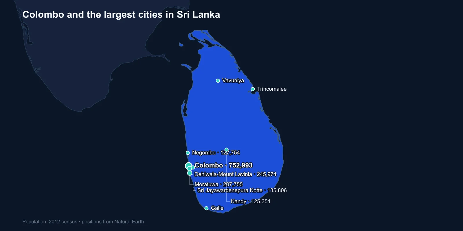
The largest cities in Sri Lanka are Colombo (752,993), Dehiwala-Mount Lavinia (245,974), Moratuwa (207,755), Sri Jayawardenepura Kotte (135,806), Negombo (127,754), Kandy (125,351), Kalmunai (106,783), Vavuniya (99,653), Galle (99,478) and Trincomalee (99,135). These are 2012 census figures for municipal areas.
Two things about that list need explaining straight away. The official capital sits in fourth place, and the numbers look far too small for a country of 22 million — because Sri Lankan municipal boundaries are drawn very tightly.
The Capital Is a Suburb
Sri Lanka's legislative capital is Sri Jayawardenepura Kotte, which is where parliament sits. It is about eight kilometres from central Colombo and entirely within the same continuous built-up area.
The move was decided in the late 1970s under J. R. Jayewardene, and parliament opened there in 1982 on an island in the Diyawanna Oya marshes, in a building by Geoffrey Bawa — the architect who defined tropical modernism in South Asia. Kotte had been the capital of a fifteenth-century kingdom, which gave the relocation a historical justification.
The executive, the supreme court and every commercial function stayed in Colombo. So Sri Lanka has a capital that is administratively real, geographically inseparable from the larger city, and unknown to most people outside the country.
Why the Numbers Look So Small
Colombo's municipal council covers about 37 square kilometres. The Colombo metropolitan area — running down the coast through Dehiwala-Mount Lavinia and Moratuwa, inland through Kotte and up towards Negombo — holds something in the region of five to six million people, a quarter of the national population.
Entries two, three and four on this list are all part of it. Dehiwala-Mount Lavinia and Moratuwa are continuous coastal suburbs south of the centre, and the built-up area does not break between them.
Sri Lanka is also one of the least urbanised countries in Asia by official measures, with figures often quoted around 19 per cent. That number is an artefact of the same boundary problem: it counts only municipal and urban councils, and a great deal of dense, functionally urban settlement is classified as rural.
A Harbour That Every Empire Wanted
Colombo's natural harbour and its position on the Indian Ocean trade routes made it a target for each maritime power in turn. The Portuguese fortified it from 1517, the Dutch took it in 1656, the British took it in 1796, and each left a layer.
The Fort district still carries the name of the Dutch defences, and the Pettah bazaar beside it is the commercial core. The Galle Face Green promenade was laid out by the British along the seafront.
The most significant recent addition is Colombo Port City, an area of land reclaimed from the sea beside the old port with Chinese financing, intended as a financial district with its own legal framework. It has been the focus of sustained argument about debt, sovereignty and Chinese influence in the Indian Ocean.
Kandy, and the Kingdom That Held Out
Kandy sits in the central highlands at about 500 metres and was the capital of the last independent Sinhalese kingdom, which resisted European control for three centuries after the coast had fallen. It was ceded to the British only in 1815, by a convention with the chiefs rather than by conquest.
The Temple of the Tooth holds a relic believed to be a tooth of the Buddha, and possession of it has been treated as conferring the right to rule the island. The Esala Perahera each summer, a procession of dancers, drummers and caparisoned elephants, is among the largest Buddhist festivals anywhere.
The city and its sacred precinct are a UNESCO World Heritage Site, and the surrounding hills are the centre of the tea industry that the British established after coffee blight destroyed the previous plantation crop in the 1870s.
The Coastal Cities and the Tsunami
Galle in the south has the best-preserved European fortification in Asia — a Dutch walled town of 1663 built on a promontory, now a World Heritage Site with its ramparts, warehouses and grid of streets intact.
On 26 December 2004 the Indian Ocean tsunami struck the southern and eastern coasts. Around 35,000 people were killed in Sri Lanka, and the disaster included the single deadliest rail accident in history when a wave overturned a crowded train near Peraliya, killing well over a thousand passengers.
Negombo, north of Colombo, came through better. It is a fishing town with a large Catholic population — a legacy of Portuguese conversion — and a lagoon system fished from outrigger craft, and it serves as the town nearest the international airport.
The North and East Are on This List for a Reason
Vavuniya, Trincomalee and Kalmunai are the northern and eastern entries, and each reflects the island's ethnic geography. Sri Lanka's Tamil population is concentrated in the north and east; Kalmunai on the east coast has a Muslim majority.
The civil war between the government and the Tamil Tigers ran from 1983 to 2009 and was fought largely in those regions. Vavuniya sat on the boundary of government-held territory for much of it and became a transit and detention point; Jaffna, the historic Tamil cultural capital in the far north, was besieged and its population halved.
Trincomalee has one of the finest deep-water natural harbours in the world, which made it a strategic prize for the Royal Navy and, in a different way, a target during the war.
Batticaloa further south, and Jaffna in the far north, complete the picture. Jaffna's population has partly returned since 2009 and its university, library — burned in 1981 in an act still treated as a turning point — and peninsula agriculture have been rebuilt, but the city has not regained the standing it held before the war.
The Tea, the Hills and the Plantation Tamils
The hill country around Nuwara Eliya and Hatton holds the tea estates, and the workforce that built them was brought from southern India by the British in the nineteenth century — a community distinct from the Tamils of the north in origin, dialect and history.
Those workers were rendered stateless by citizenship legislation after independence in 1948, and the question was only fully resolved in 2003. The estate towns remain small, and their populations are counted as rural, which is another reason the urban share looks low.
The railway the British built to carry the tea down is still running, and the line from Kandy through Hatton to Badulla is routinely described as one of the most scenic in the world, climbing through the estates at Nanu Oya and Haputale on gradients worked by locomotives more than half a century old.
Tea remains one of the country's largest export earners, and Ceylon tea is still sold under the island's colonial name — one of the few cases where a former name survives commercially because the brand was worth more than the correction.
The Ancient Cities Nobody Lives In
Sri Lanka's most celebrated urban sites are archaeological. Anuradhapura was the capital for more than a thousand years from the fourth century BC, with enormous brick stupas — the Jetavanaramaya was among the tallest structures in the ancient world — and an irrigation system of reservoirs, called tanks, that supported a very large population in the dry zone.
Polonnaruwa succeeded it in the eleventh century, and Sigiriya, the rock fortress with its frescoes and mirror wall, was briefly a royal capital in the fifth. All three are World Heritage Sites, and together with Kandy and Dambulla they form the cultural triangle that most visitors tour.
The modern towns at Anuradhapura and Polonnaruwa are small. The ancient hydraulic civilisation that built them declined after repeated invasions from south India, the population shifted to the wet south-west, and the dry-zone tanks silted up — a relocation of the island's centre of gravity that has never reversed.
What Has Changed Since 2012
The 2012 census was the first conducted across the whole island since 1981, the war having made a complete count impossible for three decades. A subsequent census was carried out in 2024.
The intervening years included the Easter Sunday bombings of 2019, which hit churches and hotels in Colombo, Negombo and Batticaloa, and the economic collapse of 2022, when the country defaulted on its foreign debt, ran out of fuel and cooking gas, and saw protesters occupy the presidential residence in Colombo.
That crisis drove substantial emigration and a return of some urban residents to family land in the villages, so the 2012 municipal figures should be treated as a structural guide rather than a current headcount.
One Conurbation and Its Regional Centres
Sri Lanka's ranking is really a ranking of one conurbation and a set of regional centres: a colonial port that became a metropolis, a parliament built in a marsh beside it, a highland kingdom that held out until 1815, a Dutch fort town, and three cities in the north and east that the civil war defined.
Buddhist, Hindu, Muslim and Christian Sri Lanka all appear on this list, and Sri Lankan religious life sorts out which city belongs to which. The parliament built in the marsh has a profile of its own. The highlands, dry zone and coast that the island’s population has shifted between are in our Sri Lanka country guide.
