
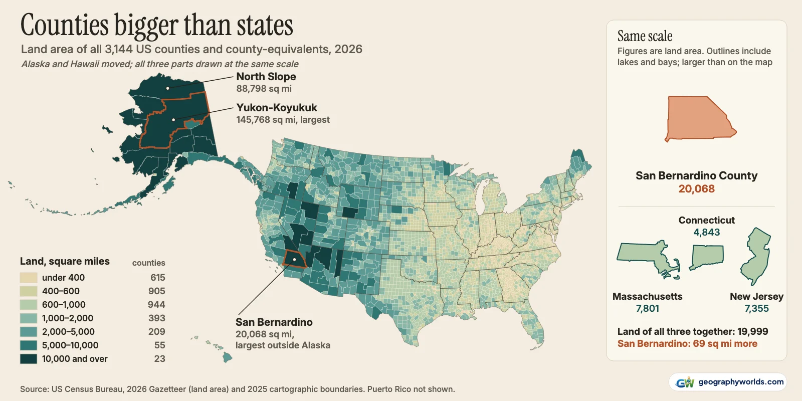
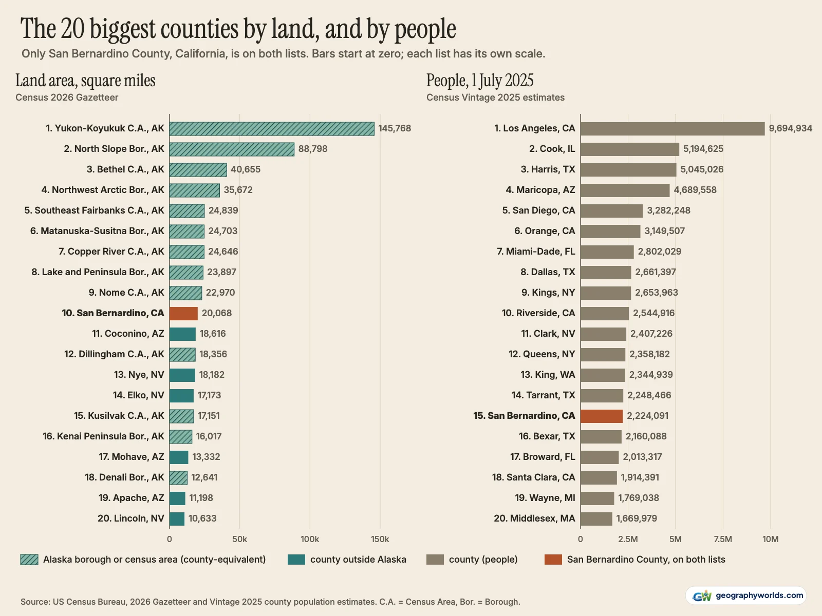
By land area, the largest county-equivalent in the United States is Alaska's Yukon-Koyukuk Census Area, with 145,768 square miles (377,536 km²) of land, more than the whole state of Montana. The North Slope Borough is second at 88,798 square miles, and nine of the ten largest are Alaskan boroughs or census areas. Outside Alaska, the largest county is San Bernardino County, California, with 20,068 square miles (51,977 km²), more land than Massachusetts, New Jersey and Connecticut combined. By population, the largest is Los Angeles County, with 9,694,934 residents on 1 July 2025, more than 40 of the 50 states. These rankings use land area from the Census Bureau's 2026 Gazetteer and its Vintage 2025 population estimates for all 3,144 counties and county-equivalents.
The comparison with states is the striking part. Counties are subdivisions, and most are modest: the median one has 616 square miles of land and 26,231 people. A few in the West and in Alaska are larger than entire states, and the most crowded counties are some of the smallest on the map.
San Bernardino County has more land than three states put together
San Bernardino County runs from the edge of the Los Angeles basin to the Nevada and Arizona borders. Its 20,068 square miles of land are 13% of California's. Massachusetts (7,801 square miles of land), New Jersey (7,355) and Connecticut (4,843) add up to 19,999, so the county is larger than all three together, by 69 square miles. That holds on land only; counted with their bays and coastal water, the three states reach 24,817 square miles against the county's 20,106.
On its own the county has more land than nine states: Rhode Island, Delaware, Connecticut, Hawaii, New Jersey, Massachusetts, New Hampshire, Vermont and Maryland, the largest of them at 9,711 square miles. It would hold Rhode Island 19 times over. West Virginia, at 24,041 square miles, is the smallest state with more land than San Bernardino County. Our guide to the smallest states in the US by area has all nine.

San Bernardino is not alone. Coconino County, Arizona (18,616 square miles), Nye County, Nevada (18,182) and Elko County, Nevada (17,173) each have more land than the same nine states. All three are thinly settled: Coconino has 144,368 residents and Nye 57,336. Arizona places six counties and Nevada five among the 20 largest outside Alaska, and outside Alaska they are the states whose counties are biggest on average: Arizona's 15 counties average 7,577 square miles of land and Nevada's 17 (counting Carson City) average 6,462. California adds Inyo County (10,197 square miles) and, in 20th place, Kern County (8,135).
Alaska's boroughs and census areas, ranked like counties
Alaska has no counties. Its 30 county-equivalents are of two kinds. Boroughs (including city-and-borough and municipality forms such as Anchorage) are local governments. Census areas, which cover the large part of the state outside any borough, are, in the Census Bureau's words, "statistical areas established in cooperation with state government", according to its guide to Alaska's geography. The bureau treats both as county-equivalents, so we rank them alongside counties and mark them. Today there are 11 census areas, 13 boroughs, four cities and boroughs, and two municipalities.
| Rank | County or county-equivalent | Type | Land, sq mi | Land, km² | People, July 2025 |
|---|---|---|---|---|---|
| 1 | Yukon-Koyukuk Census Area, Alaska | Alaska census area | 145,768 | 377,536 | 5,028 |
| 2 | North Slope Borough, Alaska | Alaska borough | 88,798 | 229,985 | 10,582 |
| 3 | Bethel Census Area, Alaska | Alaska census area | 40,655 | 105,296 | 18,391 |
| 4 | Northwest Arctic Borough, Alaska | Alaska borough | 35,672 | 92,391 | 7,095 |
| 5 | Southeast Fairbanks Census Area, Alaska | Alaska census area | 24,839 | 64,333 | 7,270 |
| 6 | Matanuska-Susitna Borough, Alaska | Alaska borough | 24,703 | 63,981 | 118,666 |
| 7 | Copper River Census Area, Alaska | Alaska census area | 24,646 | 63,833 | 2,666 |
| 8 | Lake and Peninsula Borough, Alaska | Alaska borough | 23,897 | 61,892 | 1,357 |
| 9 | Nome Census Area, Alaska | Alaska census area | 22,970 | 59,492 | 9,830 |
| 10 | San Bernardino County, California | county | 20,068 | 51,977 | 2,224,091 |
| 11 | Coconino County, Arizona | county | 18,616 | 48,216 | 144,368 |
| 12 | Dillingham Census Area, Alaska | Alaska census area | 18,356 | 47,542 | 4,483 |
| 13 | Nye County, Nevada | county | 18,182 | 47,091 | 57,336 |
| 14 | Elko County, Nevada | county | 17,173 | 44,479 | 54,815 |
| 15 | Kusilvak Census Area, Alaska | Alaska census area | 17,151 | 44,422 | 7,932 |
| 16 | Kenai Peninsula Borough, Alaska | Alaska borough | 16,017 | 41,484 | 61,951 |
| 17 | Mohave County, Arizona | county | 13,332 | 34,530 | 228,102 |
| 18 | Denali Borough, Alaska | Alaska borough | 12,641 | 32,741 | 1,616 |
| 19 | Apache County, Arizona | county | 11,198 | 29,004 | 64,445 |
| 20 | Lincoln County, Nevada | county | 10,633 | 27,540 | 4,320 |
The Yukon-Koyukuk Census Area covers 145,768 square miles of land in Alaska's interior and takes its name from the Yukon and Koyukuk rivers. That is 217 square miles more than Montana's 145,550, and it stays ahead on total area too (147,878 against 147,043). Only Alaska, Texas and California have more land. It is 26% of Alaska, and its 5,028 residents work out at 3.4 people per 100 square miles. Because it is a census area, it has no county government of its own.

The largest county-equivalent that does have a government is the North Slope Borough, along the Arctic coast: 88,798 square miles of land, more than 40 states, and 94,828 in total. The borough itself says it covers "nearly 95,000 square miles", which matches the total figure. Bethel Census Area is third with 40,655 square miles of land; an Alaska Department of Labor profile put Bethel at 41,087 square miles and noted that only Yukon-Koyukuk and the North Slope encompass more land. Northwest Arctic Borough (35,672) is fourth.
Alaska's units hold thirteen of the 20 places in the overall ranking. Recent boundary changes matter here: the Valdez-Cordova Census Area was split into the Chugach and Copper River census areas effective 2 January 2019, which is why older lists show Valdez-Cordova and today's show Copper River in 7th place with 24,646 square miles. The Matanuska-Susitna Borough, sixth by area, is the exception to the empty-interior pattern, with 118,666 residents north of Anchorage. For how all of this adds up to a state, see our piece on how big Alaska is.
Los Angeles County and the other population giants
Los Angeles County had 9,694,934 residents on 1 July 2025 in the Census Bureau's estimates, on 4,060 square miles (10,516 km²) of land. Only ten states had more people: California itself, Texas, Florida, New York, Pennsylvania, Illinois, Ohio, Georgia, North Carolina and Michigan, the last with 10.13 million. New Jersey, at 9.55 million, and the other 39 states have fewer. The county's own website says it is "exceeded by only eight states", but it pairs that with an older figure of 10.4 million residents. California's Department of Finance, which makes its own estimates, puts the county at 9,837,286 on 1 January 2026; it uses a different method and date, and its own release advises against comparing its figures with the Census Bureau's. On either source Los Angeles County leads by millions.
| Rank | County | People, 1 July 2025 | Change since April 2020 | Land, sq mi | Rank by land area |
|---|---|---|---|---|---|
| 1 | Los Angeles County, California | 9,694,934 | −322,480 | 4,060 | 118 |
| 2 | Cook County, Illinois | 5,194,625 | −84,385 | 945 | 751 |
| 3 | Harris County, Texas | 5,045,026 | +314,618 | 1,707 | 352 |
| 4 | Maricopa County, Arizona | 4,689,558 | +264,256 | 9,202 | 28 |
| 5 | San Diego County, California | 3,282,248 | −16,400 | 4,211 | 111 |
| 6 | Orange County, California | 3,149,507 | −37,772 | 793 | 1,081 |
| 7 | Miami-Dade County, Florida | 2,802,029 | +100,267 | 1,900 | 302 |
| 8 | Dallas County, Texas | 2,661,397 | +49,310 | 873 | 931 |
| 9 | Kings County, New York | 2,653,963 | −82,328 | 69 | 3,096 |
| 10 | Riverside County, California | 2,544,916 | +124,954 | 7,209 | 42 |
| 11 | Clark County, Nevada | 2,407,226 | +140,780 | 7,892 | 37 |
| 12 | Queens County, New York | 2,358,182 | −47,245 | 109 | 3,082 |
The county has also lost more people than any other since April 2020: 322,480 fewer than its April 2020 estimates base of 10,017,414. Cook County, Illinois, home to Chicago, is second with 5,194,625 and lost 84,385. Harris County, Texas, around Houston, gained 314,618, the largest increase of any county, and has closed most of the gap: Cook led by 548,602 people in 2020 and by 149,599 in 2025. Maricopa County, Arizona, fourth with 4,689,558, gained 264,256, the second-largest increase.
Density is a different list. New York County (Manhattan) packs 1,664,862 people into 22.7 square miles of land, 73,478 per square mile, the highest of any county. Kings County (Brooklyn) has 2,653,963 people on 69 square miles, ninth by population and among the smallest counties by area. At the other end, Loving County, Texas, had an estimated 52 residents and Kalawao County, Hawaii, 82.
Size and population rarely meet
Put the two rankings side by side and they barely overlap. San Bernardino County is the only county in both top 20s: tenth by land and 15th by population, with 2,224,091 people. Outside Alaska, Maricopa County joins it, 14th by land with 9,202 square miles. The other 19 largest counties by area hold 810,253 people between them; the thirteen Alaskan ones, 256,867.
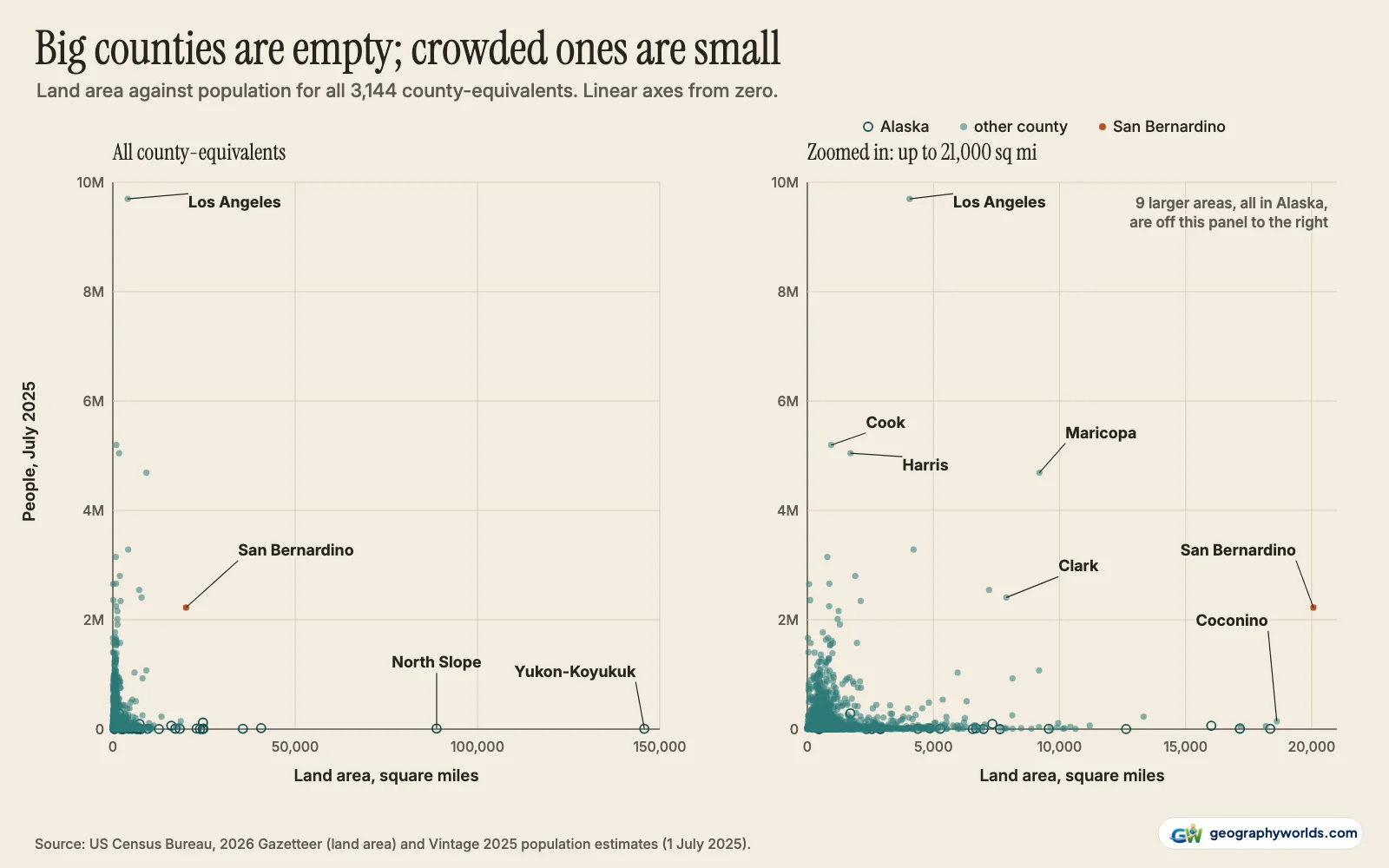
The scatter below puts every county on two linear axes. On the full scale nearly all of them collapse into one corner, which is the point: the counties far out along the area axis sit at the bottom, and the counties high on the population axis sit against the left edge. The zoomed panel shows the corner in more detail, with Los Angeles alone near the top and San Bernardino out at the right.
How we ranked them: land not water, Connecticut, and Virginia's cities
Every ranking here uses land area. Total area adds lakes, bays and coastal water inside the boundary, and it reshuffles Alaska: the Lake and Peninsula Borough, with 9,914 square miles of water inside its boundary, is eighth on land (23,897 square miles) but fifth on total area (33,810), and the Kenai Peninsula Borough rises from 16th (16,017) to tenth (24,721). The top three, and San Bernardino's place as the largest outside Alaska, are the same either way. Published figures differ for that reason and with boundary updates; San Bernardino County's own 2018 profile gives 20,053 square miles.
Connecticut abolished county government in 1960, and in 2022 the Census Bureau adopted its nine planning regions as county-equivalents, replacing the eight old counties in its data. Both the 2026 Gazetteer and the 2025 estimates use the regions, so we rank them; the largest, the Capitol Planning Region around Hartford, has 1,027 square miles and 994,115 residents. The old counties do not appear.
Virginia's 38 independent cities, plus Baltimore and St. Louis, are not part of any county and count as county-equivalents, 40 in all. They are ranked like the rest, which is why the smallest county-equivalent by land is Falls Church, Virginia, at 2.05 square miles; the smallest true county is Kalawao County, Hawaii, at 12.0 square miles. Carson City, Nevada, is a consolidated city-county (145 square miles), and the District of Columbia (61.1) is included as a county-equivalent. Puerto Rico's 78 municipios are left out, as are the other territories.
The file covers all 3,144 county-equivalents with land, water and total area in square miles and km², every rank, and the 2020 and 2025 populations. You can download the data as a CSV; if you would like to sort the West's giant counties against their populations as a chart rather than a table, Parity can build one from the spreadsheet in a few clicks. The sources:
- US Census Bureau, 2026 Gazetteer Files: counties and states: land and water area for every county and county-equivalent (released September 2026); a US government work, public domain
- US Census Bureau, County Population Totals: 2020–2025 (Vintage 2025, co-est2025-alldata): resident population estimates for 1 July 2025 and the April 2020 estimates base; public domain
- US Census Bureau, 2025 Cartographic Boundary Files (counties and states, 1:20,000,000): outlines for the map; public domain
- Federal Register, Change to County-Equivalents in the State of Connecticut (6 June 2022)
- US Census Bureau, Substantial Changes to Counties and County Equivalent Entities: 2010–2019
- California Department of Finance, E-1 population estimates, 1 January 2026 (press release)
Counties this big make most states look small, and if you want to see where Montana, the state Yukon-Koyukuk outsizes, sits among the rest, our ranking of the largest states in the US by area has all 50.