
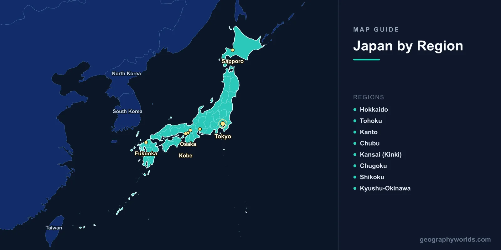
A map of Japan shows an island nation stretching 3,000 km along the eastern edge of Asia, comprising 6,852 islands across 377,975 km2 with a population of 124 million. The four main islands—Honshu, Hokkaido, Kyushu, and Shikoku—account for 97% of the land area. Japan's map reveals a mountainous archipelago sitting on the Pacific Ring of Fire, with 47 prefectures, over 100 active volcanoes, and coastlines totaling nearly 30,000 km.
Geography of Japan
Japan lies in the northwestern Pacific Ocean, separated from the Asian mainland by the Sea of Japan (East Sea). The archipelago extends from the subarctic Kuril Islands in the north to the subtropical Ryukyu Islands (Okinawa) in the south, spanning roughly 20 degrees of latitude from 24°N to 45°N.
Mountains cover approximately 73% of Japan's land area, making it one of the world's most mountainous countries. The Japanese Alps run through central Honshu with peaks exceeding 3,000 m. Mount Fuji, at 3,776 m, is Japan's highest peak and most iconic natural landmark—a nearly perfect volcanic cone visible from Tokyo on clear days.
Japan sits at the junction of four tectonic plates: the Pacific, Philippine Sea, Eurasian, and North American plates. This position creates extraordinary geological activity, including roughly 1,500 earthquakes per year that are strong enough to be felt, and 111 active volcanoes. The 2011 Tohoku earthquake (magnitude 9.1) was one of the most powerful ever recorded.
Major rivers are generally short and steep due to the mountainous terrain. The Shinano River in central Honshu is the longest at 367 km. Lake Biwa, near Kyoto, is Japan's largest lake at 670 km2 and one of the world's oldest, dating back 4 million years.

The Four Main Islands
- Honshu: The largest island (227,960 km2), home to 80% of the population. Contains Tokyo, Osaka, Nagoya, Kyoto, and Hiroshima. The Japanese Alps divide it into Pacific and Sea of Japan sides with markedly different climates.
- Hokkaido: The northernmost main island (83,424 km2). Cool climate, vast farmland, and wilderness. Capital: Sapporo (2 million). Known for dairy farming, lavender fields, and heavy winter snowfall.
- Kyushu: Southwestern island (42,191 km2). Volcanic and geothermally active, with Mount Aso's massive caldera. Major cities: Fukuoka, Kumamoto, Nagasaki. Subtropical climate in the south.
- Shikoku: The smallest main island (18,800 km2). Known for the 88-temple Buddhist pilgrimage route, the Shimanto River (one of Japan's last undammed rivers), and citrus farming. Capital: Matsuyama.
Beyond the four main islands, the Ryukyu chain (including Okinawa) extends 1,000 km southwest toward Taiwan, with a subtropical to tropical climate, coral reefs, and distinct cultural traditions. The Ogasawara (Bonin) Islands, 1,000 km south of Tokyo, are a UNESCO World Heritage Site for their unique endemic species.
47 Prefectures & Regions
Japan's 47 prefectures are grouped into eight traditional regions:
- Hokkaido: Single prefecture covering the entire northern island.
- Tohoku: Six prefectures in northern Honshu; rural, mountainous, heavy winter snow.
- Kanto: Seven prefectures including Tokyo, Saitama, Chiba, Kanagawa. Japan's population and economic center with 43 million people.
- Chubu: Nine prefectures in central Honshu; includes the Japanese Alps, Nagoya, and the Japan Sea coast.
- Kansai (Kinki): Seven prefectures; Osaka, Kyoto, Kobe, Nara. Japan's historical and cultural heartland.
- Chugoku: Five prefectures in western Honshu; Hiroshima, Okayama.
- Shikoku: Four prefectures covering the island.
- Kyushu-Okinawa: Eight prefectures; Fukuoka, Kumamoto, Okinawa.
Major Cities
- Tokyo: Capital; 14 million (city), 37.4 million (Greater Tokyo Area—world's largest metropolitan area). Located on the Kanto Plain on Tokyo Bay.
- Osaka: 2.8 million (city), 19.3 million (metro). Japan's second city, commercial hub of western Japan, on Osaka Bay.
- Nagoya: 2.3 million; central Honshu; Japan's manufacturing heartland (Toyota, aerospace).
- Sapporo: 2.0 million; Hokkaido's capital; hosted the 1972 Winter Olympics.
- Fukuoka: 1.6 million; Kyushu's largest city; closest major city to the Asian mainland.
- Kyoto: 1.5 million; former imperial capital for over 1,000 years; 17 UNESCO World Heritage Sites.
- Kobe: 1.5 million; major port city; devastated by the 1995 earthquake.
Climate Zones
- Subarctic (Hokkaido): Long, cold winters with heavy snowfall; short, cool summers. Sapporo averages -3.6°C in January.
- Humid Continental (Northern Honshu): Four distinct seasons; heavy snow on the Sea of Japan side in winter.
- Humid Subtropical (Central/Southern Honshu, Shikoku, Kyushu): Hot, humid summers; mild winters. Tokyo averages 5.2°C in January and 27.3°C in August.
- Subtropical/Tropical (Okinawa/Ryukyu): Warm year-round; typhoon season June–October. Annual temperatures 22–24°C.
Japan's climate is heavily influenced by the monsoon system. The tsuyu (rainy season) from June to mid-July brings 40–50% of annual rainfall to much of the country. Typhoons typically strike between August and October, particularly affecting Kyushu and the Pacific coast.
Key Facts About the Map of Japan
- Japan comprises 6,852 islands, but four main islands make up 97% of the land area.
- Approximately 73% of the country is mountainous and forested.
- Mount Fuji (3,776 m) last erupted in 1707 and is visible from Tokyo, 100 km away.
- Japan has 111 active volcanoes, about 10% of the world's total.
- The Greater Tokyo Area (37.4 million people) is the most populous metropolitan area on Earth.
- Japan's coastline of nearly 30,000 km is longer than that of the United States mainland.
- The Seikan Tunnel (53.85 km) connecting Honshu and Hokkaido is the world's longest undersea tunnel.
Final Thoughts
The map of Japan reveals an archipelago of remarkable geographic complexity—a narrow, mountainous chain of islands stretching from subarctic to subtropical latitudes. Its position on the Ring of Fire gives it both extraordinary natural beauty and significant geological hazards. Understanding Japan's four main islands, 47 prefectures, and diverse climate zones is essential for studying East Asian geography and appreciating how terrain and tectonics have shaped one of the world's most distinctive civilizations.
Test Your Geography Knowledge!
Think you know your maps? Try our interactive geography games!
Play Geography Games →