
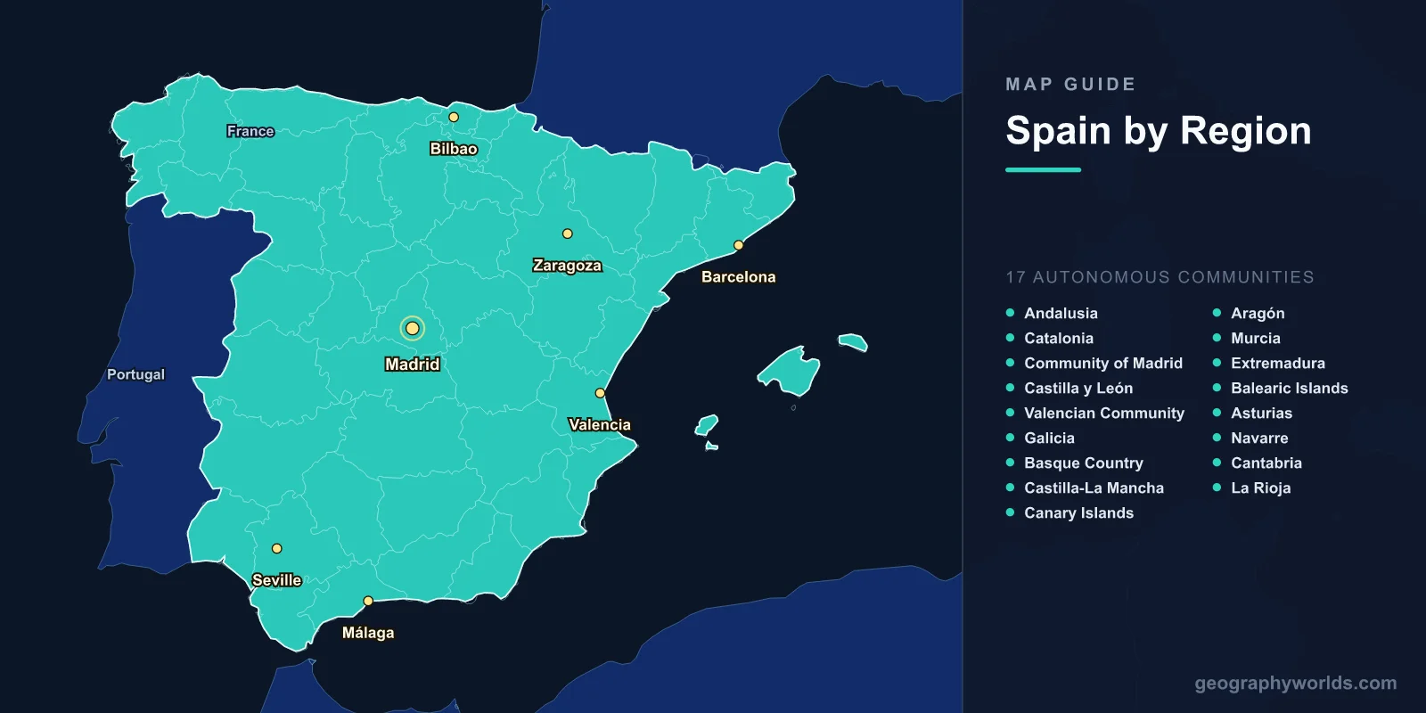
A map of Spain shows one of Europe's most geographically diverse countries, spanning 505,990 km2 across the Iberian Peninsula. The map reveals 17 autonomous communities, two autonomous cities in North Africa (Ceuta and Melilla), the Balearic Islands in the Mediterranean, and the Canary Islands in the Atlantic. Spain's terrain ranges from the snow-capped Pyrenees in the north to the semi-arid landscapes of Almería in the southeast, with the vast Meseta Central plateau dominating the interior.
Geography of Spain
Spain occupies approximately 85% of the Iberian Peninsula, which it shares with Portugal, Andorra, and Gibraltar. The country's geography is shaped by its position between the Atlantic Ocean and the Mediterranean Sea, and by a series of mountain ranges that divide the landscape into distinct climatic and cultural regions.
The Meseta Central, a massive elevated plateau averaging 600–700 m in altitude, covers roughly 40% of the country. This plateau is bisected by the Sistema Central mountain range into the northern sub-meseta (Castilla y León) and the southern sub-meseta (Castilla-La Mancha). Surrounding the Meseta are mountain chains: the Cantabrian Mountains to the north, the Iberian System to the east, and the Sierra Morena to the south.
Spain's highest peak on the mainland is Mulhacén at 3,479 m in the Sierra Nevada of Andalusia, while the country's overall highest point is Mount Teide at 3,718 m on the volcanic island of Tenerife in the Canary Islands. The Pyrenees form a formidable natural barrier along the 430 km border with France, with peaks exceeding 3,000 m.
Major rivers include the Ebro (930 km, draining to the Mediterranean), the Tagus (1,007 km total, the longest on the Iberian Peninsula), the Guadalquivir (657 km, navigable to Seville), the Duero (897 km, flowing to the Atlantic through Portugal), and the Guadiana (829 km, forming part of the Portuguese border). Spain has more than 1,200 reservoirs—more than any other European country—reflecting the challenge of managing water resources in a country with significant aridity.
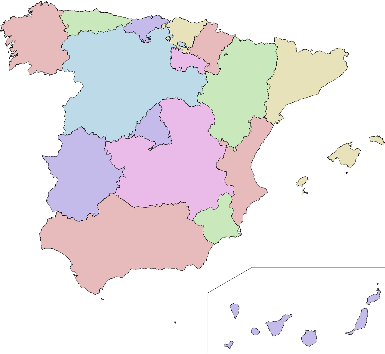
The 17 Autonomous Communities
Spain's map is divided into 17 autonomous communities (comunidades autónomas), each with its own parliament and significant self-governing powers. These communities reflect Spain's rich cultural and linguistic diversity.
- Andalusia: The largest community by population (8.5 million) and second-largest by area (87,268 km2). Capital: Seville. Includes the Sierra Nevada, Guadalquivir Valley, and Costa del Sol.
- Catalonia: Northeast Spain; capital Barcelona. A Mediterranean powerhouse with its own language and strong cultural identity. 32,108 km2.
- Community of Madrid: The capital region; 6.7 million people in just 8,028 km2, making it the most densely populated community.
- Castilla y León: The largest community by area (94,223 km2) covering the northern Meseta. Nine provinces including historic cities like Salamanca, Segovia, and Burgos.
- Valencian Community: Eastern Mediterranean coast; capital Valencia. Major rice-growing region and home to the Albufera lagoon.
- Galicia: Northwestern corner; capital Santiago de Compostela. Green, rainy, Celtic-influenced culture. Atlantic coastline with dramatic rías (fjord-like inlets).
- Basque Country: Northern Spain; capital Vitoria-Gasteiz. Distinct language (Euskara) unrelated to any other. Major industrial region with Bilbao as economic center.
- Castilla-La Mancha: Southern Meseta; Don Quixote country. Vast plains, windmills, and La Mancha wine region. Capital: Toledo.
- Canary Islands: Atlantic archipelago 1,100 km from mainland, 100 km from Africa. Seven main islands of volcanic origin. Capital shared between Las Palmas and Santa Cruz de Tenerife.
- Aragón: Northeast interior; capital Zaragoza. Spans from the Pyrenees to the Ebro Valley. 47,720 km2.
- Murcia: Southeast coast; one of the driest regions. Major fruit and vegetable production.
- Extremadura: Western border with Portugal; capital Mérida. Sparsely populated dehesa landscape of cork and holm oaks.
- Balearic Islands: Mediterranean archipelago; Mallorca, Menorca, Ibiza, and Formentera. Capital: Palma.
- Asturias: Northern coast; rugged Cantabrian Mountains; Picos de Europa National Park.
- Navarre: Northern Spain; capital Pamplona. Transition zone between wet Atlantic and dry Mediterranean climates.
- Cantabria: Northern coast; capital Santander. Green, mountainous, with prehistoric cave art at Altamira.
- La Rioja: Smallest mainland community (5,045 km2); famous wine region along the Ebro.
Major Cities
- Madrid: Capital and largest city (3.3 million city, 6.7 million metro). Sits at 667 m elevation on the Meseta Central, making it one of Europe's highest capitals. Spain's political, financial, and cultural center.
- Barcelona: 1.6 million (city), 5.6 million (metro). Mediterranean port city, capital of Catalonia. Spain's second economic engine and a global tourism destination.
- Valencia: 800,000; third-largest city on the eastern coast. Sits on the Turia riverbed (now a park) and is surrounded by the fertile huerta agricultural plain.
- Seville: 690,000; capital of Andalusia on the Guadalquivir River. The only major inland river port in Spain.
- Zaragoza: 680,000; capital of Aragón, strategically located midway between Madrid, Barcelona, Bilbao, and Valencia.
- Málaga: 580,000; gateway to the Costa del Sol and birthplace of Picasso.
- Bilbao: 345,000; largest city in the Basque Country, transformed by the Guggenheim Museum and urban renewal.
Spain's urban geography shows a strong concentration around Madrid and the Mediterranean coast. The Madrid-Barcelona axis is the country's primary economic corridor, connected by high-speed rail (AVE) covering the 621 km distance in about 2.5 hours.
Climate Zones
Spain's map reveals at least five distinct climate zones, more than almost any other European country:
- Mediterranean: Covers most of the eastern and southern coasts. Hot, dry summers (30–40°C) and mild, wet winters. Annual rainfall 300–800 mm.
- Oceanic: Northern coast (Galicia, Asturias, Cantabria, Basque Country). Cool summers, mild winters, rain throughout the year. 1,000–2,000 mm annual precipitation.
- Continental Mediterranean: Interior Meseta. Hot summers (often exceeding 40°C in July), cold winters with frost. Large daily and seasonal temperature swings.
- Semi-arid: Southeast (Almería, Murcia). Less than 300 mm annual rainfall. Europe's only true desert landscapes at Tabernas.
- Subtropical: Canary Islands. Warm year-round (18–24°C), with variation from arid coasts to lush cloud forests at altitude.
Key Facts About the Map of Spain
- Spain is the second-largest country in the EU by area at 505,990 km2.
- The country has over 8,000 km of coastline across the Mediterranean, Atlantic, and Bay of Biscay.
- Mount Teide on Tenerife (3,718 m) is the highest peak in Spain and the tallest mountain in the Atlantic islands.
- Spain has 50 UNESCO World Heritage Sites, third-most worldwide after Italy and China.
- The Meseta Central plateau covers about 40% of Spain's land area at 600–700 m elevation.
- Spain's Tabernas Desert in Almería is often called Europe's only true desert.
- The country receives about 3,000 hours of sunshine annually in the south—more than any other European nation.
Final Thoughts
The map of Spain reveals a country of extraordinary geographic contrasts packed into a relatively compact area. From the green, rain-soaked mountains of Galicia to the sun-baked plains of Castilla-La Mancha, from the volcanic Canary Islands to the Pyrenean peaks, Spain's 17 autonomous communities each offer distinct landscapes and climates. Understanding this geographic diversity is essential for anyone studying European geography, planning travel across the Iberian Peninsula, or exploring how terrain and climate have shaped one of Europe's most culturally rich nations.
Test Your Geography Knowledge!
Think you know your maps? Try our interactive geography games!
Play Geography Games →