
Introduction
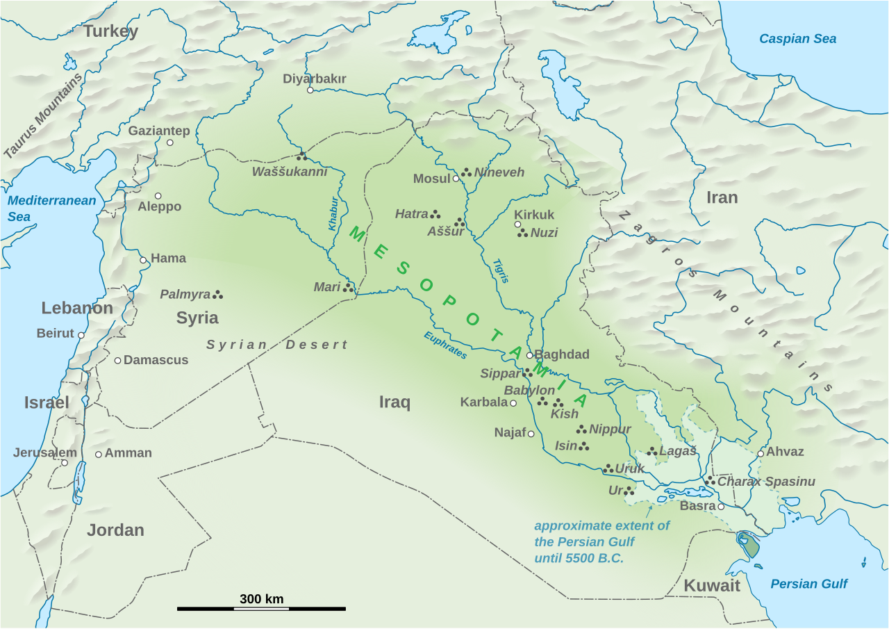
The Mesopotamia civilization emerged in a geographic setting that profoundly shaped its development, culture, and legacy. Mesopotamia ('land between the rivers') occupied the alluvial plain between the Tigris and Euphrates rivers in modern-day Iraq and parts of Syria, Turkey, and Iran. The terrain was predominantly flat river floodplain and delta, bordered by the Zagros Mountains to the east and the Syrian-Arabian desert to the west. At its extent, the civilization covered approximately 300,000–500,000 km² for the core Mesopotamian alluvial plain; the broader Fertile Crescent extends over 500,000 km². The population varied greatly over millennia: Ur had approximately 65,000 people circa 2000 BCE; Babylon may have reached 200,000 at its peak under Nebuchadnezzar II (circa 600 BCE), possibly the largest city in the world at the time. The entire Mesopotamian region may have supported 1–2 million people during peak periods. Key geographic features of the Mesopotamia world included Tigris-Euphrates river system — twin rivers whose alluvial deposits created one of the world's most fertile plains, Fertile Crescent — arc of productive land from the Persian Gulf to the Mediterranean, birthplace of agriculture, Mesopotamian Marshes (Ahwar) — vast wetlands at the Tigris-Euphrates confluence, covering up to 20,000 km² historically, Shatt al-Arab — 200 km waterway formed by the Tigris-Euphrates confluence flowing into the Persian Gulf, and Zagros Mountain foothills — eastern boundary with evidence of earliest farming settlements.

Physical Geography
The physical geography of the Mesopotamia homeland featured diverse and strategically important terrain. Mesopotamia ('land between the rivers') occupied the alluvial plain between the Tigris and Euphrates rivers in modern-day Iraq and parts of Syria, Turkey, and Iran. The terrain was predominantly flat river floodplain and delta, bordered by the Zagros Mountains to the east and the Syrian-Arabian desert to the west. Mountain systems included Mesopotamia proper was largely flat, but the civilization's influence extended to the Zagros Mountains to the east (peaks reaching over 4,000 m including Cheekha Dar at 3,611 m — highest point in modern Iraq) and the Taurus Mountains to the north in southeastern Turkey (Demirkazık at 3,756 m). The foothills of these ranges at 300–900 m elevation were where agriculture first developed.. Critical waterways included Euphrates River (2,800 km, longest river in Western Asia, originating in eastern Turkey), Tigris River (1,900 km, originating in southeastern Turkey), Greater Zab River (392 km, major Tigris tributary), Lesser Zab River (400 km), Diyala River (445 km, Tigris tributary in Iraq), Karun River (950 km, joining the Shatt al-Arab from Iran). Annual spring flooding deposited fertile silt but was unpredictable and required extensive canal management.. These physical features provided natural boundaries, transportation routes, and resources essential to the civilization's growth.
Climate & Weather
The climate of the Mesopotamia heartland played a crucial role in agricultural development and seasonal activities. Hot semi-arid to arid climate. Summers are extremely hot with temperatures exceeding 50°C in southern Iraq. Winters are mild (5–15°C). Annual rainfall is 100–200 mm in the south (insufficient for rain-fed agriculture, requiring irrigation) and 300–500 mm in the north (sufficient for dry farming). Dust storms (shamal winds) are common in summer. The civilization's understanding of seasonal weather patterns informed agricultural techniques, water management systems, and settlement planning across their territory.
Natural Resources & Environment
The Mesopotamia civilization depended on diverse natural resources for its prosperity. Fertile alluvial soil (the primary resource enabling civilization), barley and wheat (first domesticated in the Fertile Crescent circa 9500 BCE), dates, sesame, flax, wool from sheep and goats, bitumen (natural asphalt from seeps, used in waterproofing), clay (for tablets, pottery, and bricks — the primary building material due to lack of stone), reeds from the marshes, fish. Imported resources included timber from Lebanon and the Zagros, stone, and metals (copper, tin, gold). The region's ecosystems included River floodplain and alluvial ecosystems, marshland wetlands (the Mesopotamian Marshes are a UNESCO World Heritage Site), desert steppe, riparian gallery forests along rivers, saline flats in areas affected by irrigation-induced soil salinization. The Mesopotamian Marshes were home to a unique culture of Marsh Arabs and supported extensive bird, fish, and mammal populations until drained in the 1990s (partially restored since 2003). Resource management was central to Mesopotamia governance, economy, and cultural practice.
Human Geography
The Mesopotamia civilization's population centers reflected geographic realities. The civilization supported approximately Mesopotamia's population varied greatly over millennia. Ur had approximately 65,000 people circa 2000 BCE. Babylon may have reached 200,000 at its peak under Nebuchadnezzar II (circa 600 BCE), possibly the largest city in the world at the time. The entire Mesopotamian region may have supported 1–2 million people during peak periods.. Major centers included Babylon,Ur,Uruk,Nineveh,Assur,Lagash,Eridu,Nippur,Akkad,Mari. The capital was Multiple capitals across different empires: Ur (Third Dynasty of Ur), Babylon (Babylonian Empire — Nebuchadnezzar II expanded it to over 10 km² with the famous Ishtar Gate), Nineveh (Assyrian Empire — at its peak one of the largest cities in the world), Akkad (Akkadian Empire). Urban planning reflected an understanding of geographic constraints and opportunities.
Key Geographic Facts
- Mesopotamia is where agriculture was first developed around 9500 BCE, leading to the first permanent settlements
- The Sumerians invented cuneiform writing around 3400 BCE, one of the earliest known writing systems in the world
- The Code of Hammurabi (circa 1754 BCE) is one of the oldest known written legal codes, inscribed on a 2.25 m tall stele
- Mesopotamians developed the sexagesimal (base-60) number system, which is why we have 60 seconds in a minute and 360 degrees in a circle
- Soil salinization from millennia of irrigation gradually reduced agricultural productivity in southern Mesopotamia, contributing to the decline of Sumerian cities
Fun Facts
- The ancient city of Uruk may have been the world's first true city, reaching a population of 40,000–80,000 by 2900 BCE and giving its name to modern Iraq
- The Epic of Gilgamesh, written in Mesopotamia around 2100 BCE, is considered the oldest known work of great literature
- The Hanging Gardens of Babylon, one of the Seven Wonders of the Ancient World, may not have been in Babylon at all — some scholars believe they were in Nineveh
- Mesopotamians brewed beer as early as 3500 BCE — a Sumerian poem to the goddess Ninkasi is essentially the oldest known beer recipe
- The Mesopotamian Marshes were drained by Saddam Hussein in the 1990s as political punishment but have been partially restored since 2003, recovering about 50% of their original extent
