

Mount Everest is Earth's highest mountain above sea level, rising 8,849 meters (29,032 feet) in the Mahalangur Himal sub-range of the Himalayas. Straddling the border between Nepal and the Tibet Autonomous Region of China, it is known as Sagarmatha in Nepali and Chomolungma in Tibetan. Since the first confirmed ascent in 1953, it has stood as the ultimate symbol of mountaineering ambition and the limits of human endurance.
Everest has captivated explorers, scientists, and dreamers for more than a century. Its summit pierces the jet stream, its slopes hold the bodies of climbers who never returned, and its very rock preserves the memory of an ancient ocean. Understanding Everest means understanding plate tectonics, extreme physiology, human courage, and the mounting pressures of tourism and climate change on the world's most famous peak.
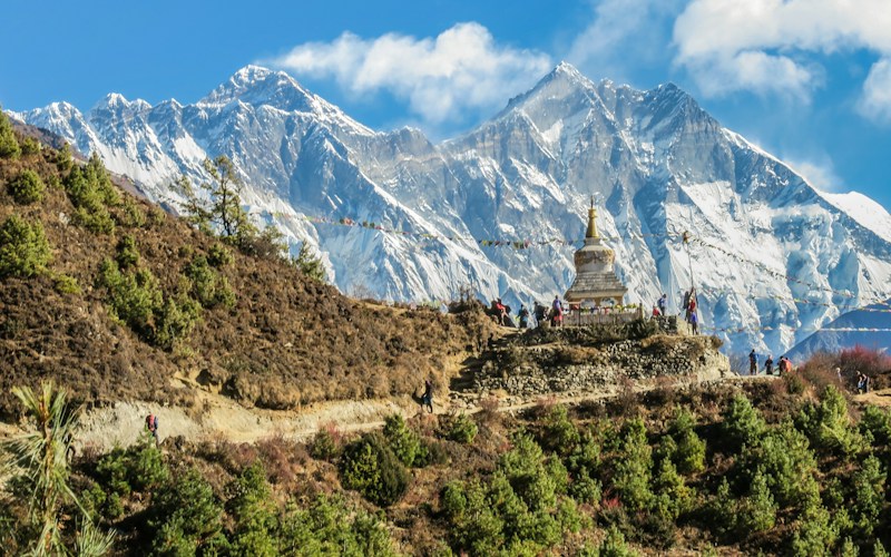
What and Where Is Mount Everest?
Mount Everest sits on the Nepal–China (Tibet) border, with its summit forming part of the international boundary. On the Nepalese side it lies within Sagarmatha National Park, a UNESCO World Heritage Site; on the Tibetan side it rises above the Rongbuk Valley. The peak takes its English name from Sir George Everest, the British Surveyor General of India, whose survey team first calculated its height in 1856 as part of the Great Trigonometrical Survey.
Long before Western surveyors arrived, the mountain was sacred to the peoples who lived in its shadow. Its indigenous names reflect that reverence: Chomolungma translates roughly to "Goddess Mother of the World," while the Nepali Sagarmatha means "Peak of Heaven" or "Forehead of the Sky." Everest is not an isolated giant but the highest of several neighbors, sharing its massif with Lhotse (8,516 m) and Nuptse, and standing near Makalu and Cho Oyu, all among the world's fourteen 8,000-meter peaks.
How Mount Everest Was Formed
Everest is a product of the slow, relentless collision of continents. Around 50 million years ago, the Indian subcontinent began crashing into the Eurasian plate, crumpling the crust between them upward into the Himalayas—the highest and geologically youngest major mountain range on Earth. This collision has never stopped, which is why the range continues to grow today.
One of Everest's most striking features is hidden in its rock. The summit is capped by marine limestone laid down on the floor of an ancient sea, the Tethys Ocean. Fossils of sea creatures embedded near the top of the world are direct evidence that this material was once underwater before being thrust skyward over millions of years. The mountain still rises by roughly 4 millimeters per year due to ongoing tectonic uplift, though major earthquakes—such as the devastating 2015 Nepal quake—can momentarily shift its height. The official elevation of 8,848.86 meters was jointly confirmed by Nepal and China in 2020 using modern satellite and survey techniques.
The History of Climbing Everest
The race to stand on the highest point on Earth produced some of the most enduring stories in exploration. British expeditions in the 1920s and 1930s, approaching from the Tibetan north, made the first serious attempts. In 1924, George Mallory—who famously answered "Because it's there" when asked why he wanted to climb the mountain—vanished near the summit with his partner Andrew Irvine. Whether they reached the top before dying remains one of mountaineering's greatest unsolved mysteries.
The breakthrough came on May 29, 1953, when New Zealander Edmund Hillary and Nepali Sherpa Tenzing Norgay reached the summit as part of a British expedition led by John Hunt. News of their success arrived in Britain on the eve of Queen Elizabeth II's coronation, electrifying the world and cementing Everest's place in popular imagination.
Later decades brought even bolder feats:
- 1975: Junko Tabei of Japan became the first woman to summit Everest.
- 1978: Reinhold Messner and Peter Habeler completed the first ascent without supplemental oxygen, defying widespread belief that it was impossible.
- 1980: Messner returned to make the first solo ascent, again without bottled oxygen.
- Record ascents: Kami Rita Sherpa holds the record for the most summits, having reached the top more than 25 times.
Routes and the Deadly Death Zone
Two routes account for the vast majority of ascents. The South Col Route from Nepal—the path of Hillary and Tenzing—climbs through the notoriously dangerous Khumbu Icefall, a shifting maze of crevasses and seracs, before reaching the South Col and the final summit ridge. The North Ridge Route from Tibet follows the original exploration line and is defined by the formidable Second Step, a near-vertical rock band high on the mountain.
Above 8,000 meters lies the infamous "death zone," where atmospheric oxygen is roughly one-third of that at sea level. Here the human body can no longer acclimatize—it can only break down. Climbers suffer hypoxia that clouds judgment, slows movement, and makes every step an ordeal. Frostbite, high-altitude pulmonary edema, and cerebral edema are constant threats, and the small windows of calm weather between deadly storms leave little margin for error.
Sherpas, Commercialization, and the Modern Mountain
The face of Everest expeditions has changed dramatically since the 1990s. Commercial outfitters now guide paying clients to the summit, making the peak accessible to fit, experienced trekkers willing to spend tens of thousands of dollars. This has opened the mountain to many but also produced crowding, "traffic jams" in the death zone, and renewed debate about safety and the spirit of mountaineering.
At the heart of nearly every expedition are the Sherpas, an ethnic group native to the Everest region. They fix ropes, ferry loads, build camps, and shepherd clients through the most dangerous terrain—often taking on far greater risk than the climbers they support. Many have died on the mountain, and their indispensable role has fueled ongoing conversations about fair pay, recognition, and safety.
Environmental Pressures on Everest
Decades of expeditions have left a heavy footprint. Discarded oxygen bottles, abandoned tents, and other refuse earned Everest the unwelcome nickname "the world's highest garbage dump." Nepal now requires climbers to carry out their waste and has organized cleanup drives that have removed many tons of debris.
Climate change adds a graver dimension. Warming temperatures are causing glaciers to retreat and the Khumbu Icefall to grow more unstable, while melting snow and ice are exposing the bodies of climbers lost decades ago. These shifts pose practical hazards for today's mountaineers and difficult ethical questions about how to manage a fragile, sacred, and increasingly crowded environment.
Key Facts
- Elevation: 8,849 meters (29,032 feet) above sea level
- Location: Nepal–China (Tibet) border, Mahalangur Himal, Himalayas
- Local names: Sagarmatha (Nepali), Chomolungma (Tibetan)
- First ascent: May 29, 1953, by Edmund Hillary and Tenzing Norgay
- Geological origin: Indo-Eurasian plate collision, ongoing for ~50 million years
- Growth rate: Rising roughly 4 millimeters per year
- Most summits: Kami Rita Sherpa, 25+ ascents
Frequently Asked Questions
How tall is Mount Everest?
Mount Everest stands 8,849 meters (29,032 feet) above sea level, making it the highest mountain on Earth measured from sea level. Its officially agreed height of 8,848.86 meters was confirmed jointly by Nepal and China in 2020.
Who was the first person to climb Mount Everest?
New Zealander Edmund Hillary and Nepali Sherpa Tenzing Norgay were the first people confirmed to reach the summit, on May 29, 1953, as part of a British expedition led by John Hunt.
Why does Everest have marine fossils at its summit?
The summit rocks are limestone formed on the floor of the ancient Tethys Ocean. When the Indian plate collided with Eurasia, that former seabed was pushed thousands of meters into the sky, carrying its fossilized sea creatures with it.
What is the "death zone" on Everest?
The death zone refers to altitudes above 8,000 meters, where oxygen is only about one-third of sea-level levels. The body cannot acclimatize there and steadily deteriorates, so climbers must move quickly and usually rely on supplemental oxygen.
