
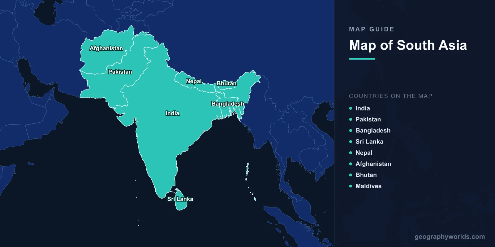
South Asia is a region encompassing 5.13 million km2 (1.98 million sq mi) with a population of approximately 1.98 billion—about 25% of the world’s people. The region includes 8 countries: India, Pakistan, Bangladesh, Sri Lanka, Nepal, Bhutan, the Maldives, and Afghanistan. Major capitals include New Delhi (28.6139°N, 77.2090°E), Islamabad, and Dhaka.
Introduction
South Asia is bounded by the Himalayas and Karakoram ranges to the north, the Indian Ocean to the south, the Bay of Bengal to the east, and the Arabian Sea to the west. The region encompasses the Indian subcontinent, the world’s highest mountain range, vast river plains, tropical islands, and one of the most productive monsoon systems on Earth.

Geographic Overview
- Area: 5.13 million km2 (1.98 million sq mi)
- Population: 1.98 billion (2024)
- Countries: 8 sovereign nations
- Highest Point: Mount Everest, 8,849 m (Nepal/China border)
- Major Rivers: Ganges, Indus, Brahmaputra
- Major Seas: Arabian Sea, Bay of Bengal, Indian Ocean
South Asia’s geography is dominated by three major features: the Himalayan mountain arc in the north, the Indo-Gangetic Plain stretching across northern India, Pakistan, and Bangladesh, and the Deccan Plateau in peninsular India. The region contains 5 of the world’s 14 peaks over 8,000 m. The Indian subcontinent was originally a separate landmass that collided with Asia 50 million years ago, creating the Himalayas.
Major Countries
- India: New Delhi; 3.29 million km2; 1.44 billion; world’s most populous country
- Pakistan: Islamabad; 881,913 km2; 231 million; Indus River valley; K2
- Bangladesh: Dhaka; 147,570 km2; 173 million; Ganges-Brahmaputra delta
- Sri Lanka: Colombo; 65,610 km2; 22 million; island south of India
- Nepal: Kathmandu; 147,516 km2; 30 million; Himalayan kingdom; Mount Everest
- Afghanistan: Kabul; 652,230 km2; 41 million; Hindu Kush mountains
- Bhutan: Thimphu; 38,394 km2; 780,000; eastern Himalayas; carbon-negative country
- Maldives: Malé; 298 km2; 521,000; lowest country on Earth; 1,192 coral islands
India dominates South Asia geographically and demographically, accounting for 64% of the region’s area and 73% of its population. Bangladesh is one of the most densely populated countries on Earth, with 173 million people in an area slightly smaller than Iowa. The Maldives, with an average elevation of just 1.5 m, is the world’s lowest-lying country and extremely vulnerable to sea level rise.
Major Geographic Features
- Himalayas: 2,400 km arc; world’s highest range; Everest, K2, Kangchenjunga
- Indo-Gangetic Plain: Flat alluvial plain; 700,000 km2; one of the most fertile areas on Earth
- Deccan Plateau: Peninsular India; ancient basalt; 1.9 million km2
- Thar Desert: 200,000 km2; India-Pakistan border; world’s most populated desert
- Western Ghats: 1,600 km mountain chain; biodiversity hotspot; southwest India
- Ganges-Brahmaputra Delta: World’s largest river delta; 100,000 km2; Bangladesh
The Himalayan system includes the Greater Himalayas (with peaks over 8,000 m), the Lesser Himalayas, and the Siwalik Hills. The Indo-Gangetic Plain, formed by river sediments, supports over 600 million people and is one of the world’s most important agricultural regions. The Western Ghats are a UNESCO World Heritage Site and one of the world’s 8 "hottest hotspots" of biodiversity.
Bodies of Water
- Ganges: 2,525 km; sacred river; drains northern India and Bangladesh
- Indus: 3,180 km; Pakistan’s lifeline; origin in Tibet
- Brahmaputra: 2,900 km; flows through Tibet, India, Bangladesh
- Bay of Bengal: 2.17 million km2; world’s largest bay; cyclone-prone
- Arabian Sea: 3.86 million km2; monsoon-influenced; western coastline
- Indian Ocean: Southern boundary; maritime trade route
South Asia’s three great river systems—the Ganges, Indus, and Brahmaputra—originate in the Himalayas and sustain the livelihoods of over a billion people. The Ganges-Brahmaputra system converges in Bangladesh to form the world’s largest river delta, draining 1.72 million km2. The Indus River is Pakistan’s primary water source, irrigating 80% of the country’s farmland.
Climate & Monsoons
- Southwest Monsoon: June–September; brings 80% of annual rainfall to most of South Asia
- Northeast Monsoon: October–December; brings rain to southeastern India and Sri Lanka
- Temperature Range: From -40°C in the Himalayas to 50°C in the Thar Desert
- Cherrapunji: Meghalaya, India; one of the wettest places on Earth; 11,777 mm/year
The South Asian monsoon is the most significant seasonal weather system on Earth, directly affecting nearly 2 billion people. The monsoon delivers 80% of the region’s annual rainfall in just four months. Failure of the monsoon leads to drought and famine, while excessive rainfall causes devastating floods. Mawsynram and Cherrapunji in India’s Meghalaya state are among the wettest places on Earth.
Key Facts
- South Asia is home to nearly 2 billion people—25% of the world’s population on 3.5% of its land.
- The Himalayas contain 5 of the world’s 14 peaks over 8,000 m.
- The Ganges-Brahmaputra Delta is the world’s largest river delta at 100,000 km2.
- The Maldives (average elevation 1.5 m) is the lowest-lying country on Earth.
- The South Asian monsoon delivers 80% of the region’s annual rainfall in four months.
Fun Facts
- India’s Cherrapunji once received 26,461 mm of rain in a single year (1860–1861)—the highest annual rainfall ever recorded.
- K2 (8,611 m), on the Pakistan-China border, has a higher fatality rate for climbers than Mount Everest.
- Bangladesh’s Sundarbans mangrove forest is home to the world’s largest population of Bengal tigers.
- Bhutan measures its success by Gross National Happiness rather than GDP.
Final Thoughts
South Asia’s map reveals a region of staggering geographic contrasts—from the highest mountains on Earth to the lowest-lying island nation, from the driest desert to the wettest places on the planet. Understanding its 8 countries, the Himalayan system, the monsoon cycle, and the great river plains is essential for grasping the geography of nearly a quarter of humanity.
Test Your Geography Knowledge!
Think you know your maps? Try our interactive geography games!
Play Geography Games →