
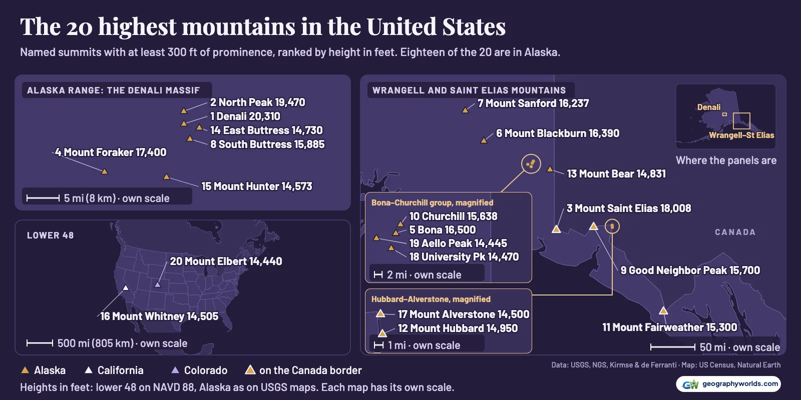
The tallest mountain in the United States is Denali in Alaska, 20,310 ft (6,190 m) above sea level. Counting every named summit that stands at least 300 ft above the saddle linking it to higher ground, Alaska holds 18 of the 20 highest: Denali's North Peak (19,470 ft) is second, Mount Saint Elias (18,008 ft) third and Mount Foraker (17,400 ft) fourth. Outside Alaska the highest is California's Mount Whitney at 14,505 ft (4,421 m), followed by Colorado's Mount Elbert (14,440 ft), Mount Massive (14,428 ft) and Mount Harvard (14,427 ft), then Washington's Mount Rainier (14,406 ft). Colorado holds sixteen of the lower 48's top 20, California three and Washington one.
Both lists start from the US Geological Survey's own table of named summits over 14,000 ft, plus every other summit in the federal names database (GNIS), within 5 miles of one, that the USGS elevation model puts above 14,000 ft. Heights in the lower 48 are moved to the modern NAVD 88 datum with NOAA's conversion tool and checked against National Geodetic Survey summit stations and USGS lidar; Alaska's come mostly from USGS maps. A summit counts as its own mountain only with at least 300 ft of prominence, here taken from a global terrain model built by Andrew Kirmse and Jonathan de Ferranti. That rule is what lets Denali's North Peak in and keeps 15 other named summits out.
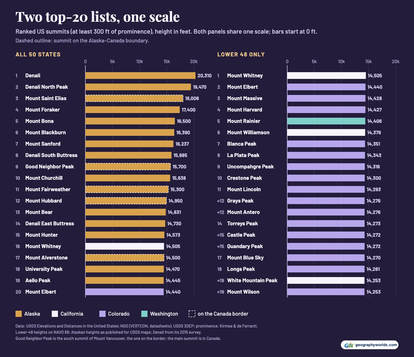
Alaska's ranges take eighteen of the top twenty
Denali's summit was re-measured in 2015 by a USGS-led GPS team, which fixed it at 20,310 ft, 20,320 ft having been the figure since the 1950s. Its federal name has been Mount McKinley again since 2025, as GNIS now lists it, while the park keeps Denali; our explainer on why Denali was renamed Mount McKinley covers the politics.
Four of the top 14 are parts of that one mountain. The North Peak, 19,470 ft, rises about 1,351 ft above the saddle between the two summits in the terrain model, far past the threshold, so it ranks second in the country. Two lower spurs pass the 300 ft test by much less: the South Buttress (15,885 ft, 364 ft of prominence) and the East Buttress (14,730 ft, 342 ft). Browne Tower, 14,530 ft on the USGS list, does not separate from the ridge by even 100 ft and drops out, as do Archdeacons Tower, Carter Horn and Farthing Horn, named points within 2 miles of the summit that the USGS list leaves out. Both margins are thin: Wikipedia's fourteener table gives the South Buttress 315 ft and the East Buttress 380 ft, so the South Buttress lies between 315 and 364 ft and the East Buttress between 342 and 380 ft. If the South Buttress dropped out, Mount Massive would enter the top 20 and Alaska would hold 17. Mount Foraker (17,400 ft) and Mount Hunter (14,573 ft) stand apart to the south-west.

Most of the rest stand 226 to 534 miles to the east and south-east, where the Wrangell and Saint Elias Mountains meet the Gulf of Alaska. Mount Saint Elias, 18,008 ft, is the country's third-highest summit and sits on the Canadian border; so do four more of the top 20: Mount Fairweather (15,300 ft), Mount Hubbard (14,950 ft), Mount Alverstone (14,500 ft) and Good Neighbor Peak, the south summit of Mount Vancouver. Wikipedia's entry on Mount Vancouver describes that south summit as straddling the border and the mountain's northern side as lying in Yukon, so only the border summit counts here, at the 15,700 ft GNIS gives it.
Just inside Alaska, Mount Bona (16,500 ft) and its neighbour Mount Churchill (15,638 ft) lead a cluster that includes University Peak (14,470 ft), Mount Bear (14,831 ft) and Aello Peak (14,445 ft), which only the National Park Service's list of Alaska's highest summits includes. To the north, the Wrangells add Mount Blackburn (16,390 ft) and Mount Sanford (16,237 ft), sixth and seventh in the country.
Whitney ranks only 16th nationally and Elbert 20th; Massive misses by 12 ft.
| US rank | Summit | State | Height (ft) | Height (m) | Prominence (ft) |
|---|---|---|---|---|---|
| 1 | Denali | AK | 20,310 | 6,190 | 20,194 |
| 2 | Denali North Peak | AK | 19,470 | 5,934 | 1,351 |
| 3 | Mount Saint Elias (on the Canada border) | AK | 18,008 | 5,489 | 11,236 |
| 4 | Mount Foraker | AK | 17,400 | 5,304 | 7,281 |
| 5 | Mount Bona | AK | 16,500 | 5,029 | 6,865 |
| 6 | Mount Blackburn | AK | 16,390 | 4,996 | 11,772 |
| 7 | Mount Sanford | AK | 16,237 | 4,949 | 7,791 |
| 8 | Denali South Buttress | AK | 15,885 | 4,842 | 364 |
| 9 | Good Neighbor Peak (Mount Vancouver) (on the Canada border) | AK | 15,700 | 4,785 | 425 |
| 10 | Mount Churchill | AK | 15,638 | 4,766 | 849 |
| 11 | Mount Fairweather (on the Canada border) | AK | 15,300 | 4,663 | 13,029 |
| 12 | Mount Hubbard (on the Canada border) | AK | 14,950 | 4,557 | 8,175 |
| 13 | Mount Bear | AK | 14,831 | 4,520 | 5,132 |
| 14 | Denali East Buttress | AK | 14,730 | 4,490 | 342 |
| 15 | Mount Hunter | AK | 14,573 | 4,442 | 4,511 |
| 16 | Mount Whitney | CA | 14,505 | 4,421 | 10,082 |
| 17 | Mount Alverstone (on the Canada border) | AK | 14,500 | 4,420 | 1,535 |
| 18 | University Peak | AK | 14,470 | 4,410 | 3,294 |
| 19 | Aello Peak | AK | 14,445 | 4,403 | 1,464 |
| 20 | Mount Elbert | CO | 14,440 | 4,401 | 9,079 |
Sierra Nevada against the Colorado Rockies
California has the lower 48's highest summit; Colorado has almost everything below it. Whitney stands 14,505 ft at the National Geodetic Survey's summit station, 65 ft above Elbert. California's second entry, Mount Williamson (14,376 ft), only comes sixth, behind Elbert, Massive, Harvard and Rainier, and its third, White Mountain Peak (14,253 ft), shares 19th place with Colorado's Mount Wilson. North Palisade (14,248 ft), the next Sierra summit, is 21st.
Colorado's case is depth. Five of its 16 places come from the Sawatch Range alone, including the three summits behind Whitney, and the margins are tiny: Massive beats Harvard by one foot (14,428 ft to 14,427 ft), Grays Peak and Mount Antero tie at 14,276 ft, and Castle Peak and Quandary Peak tie at 14,272 ft. Between 11th and 20th the whole contest spans only 40 ft. Another height source can reorder that stretch: 14ers.com gives Harvard 14,424 ft and Massive 14,427 ft, a lead of 3 ft. Our guide to the mountains of Colorado covers each range.
Across the whole country, 101 named summits clear 14,000 ft and 86 of them pass the prominence test. Colorado has 58 names and 53 that count, which matches the "58 named peaks" and "53" ranked summits on 14ers.com, the climbers' reference site for the state. The five names that miss in our data are Mount Cameron, El Diente Peak, North Eolus, Conundrum Peak and North Maroon Peak.
The two lists agree on the totals but not on one swap. The terrain model gives Challenger Point (14,085 ft), named for the crew of the space shuttle Challenger according to its GNIS record, 301 ft of prominence, one foot over the line, and gives North Maroon Peak only 247 ft. 14ers.com's figures reverse that, ranking North Maroon and leaving Challenger out. California shows the same knife-edge: Mount Muir, beside Whitney, comes out at 296 ft here but 331 ft on Wikipedia, which is why our count there is 11 rather than the 12 California fourteeners some lists give.
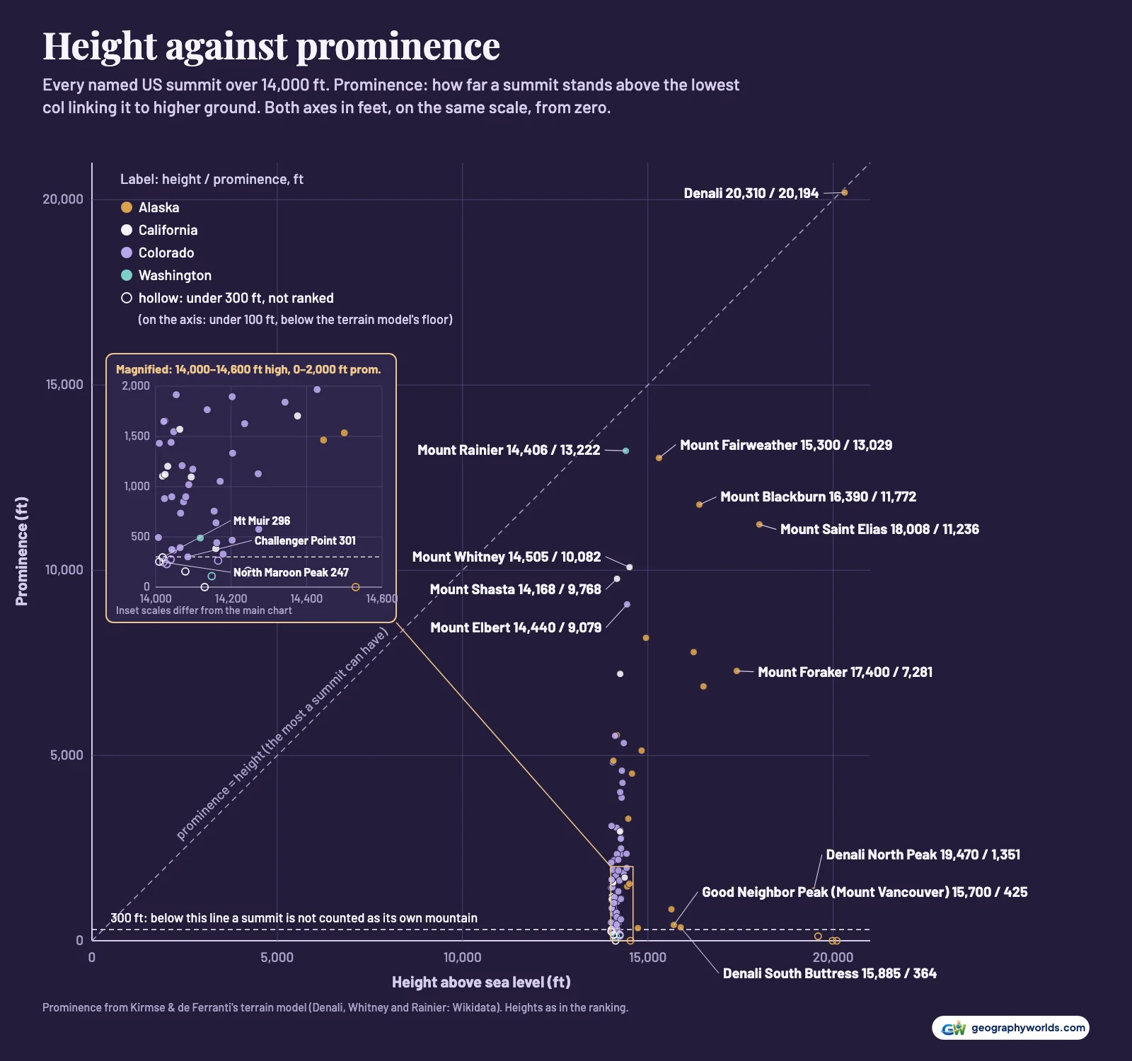
Prominence also explains why the lists split on Alaska. Wikipedia's table of fourteeners counts 96 US summits with 300 ft of prominence, 29 of them in Alaska, against our 20. The difference is mostly unnamed high points such as its Peak 14630, and with them Whitney falls below 22 Alaskan summits. We rank only named summits.
Why the published heights disagree
The single biggest source of difference is the datum, the reference surface that heights are measured from. The USGS table uses NGVD 29, the reference of the old topographic maps. Converted to NAVD 88, the system in use today, every lower-48 figure rises: by 5.6 to 7.2 ft in Colorado, taking Elbert from 14,433 ft on the 1967 map to 14,440 ft. Whitney's 14,494 ft in the table converts to about 14,500 ft; 14,505 ft is NGS's summit station, GT1811, on NAVD 88. Our explainer on how mountains are measured covers the geodesy.
Some summits have simply changed. Rainier was 14,410 ft in the USGS summit table (14,411 ft in its state high-points table) and is still 14,410 ft to the park, but a 2024 GPS survey, posted as a preprint and not an official figure, found the ice of Columbia Crest had melted below the rocky Southwest Rim, now the summit at 14,406.2 ft. Denali's 10 ft loss in 2015 was different: the USGS put it down to advances in measuring technology, not a shrinking mountain.
And some printed figures are wrong. La Plata Peak appears at 14,361 ft in the USGS table, 14,367 ft after conversion, but USGS lidar finds its highest ground at 14,343 ft, and 14ers.com gives 14,344 ft. We used the lidar figure wherever a converted map height and the lidar differed by more than 15 ft; across 70 lower-48 summits that happened only at La Plata Peak and Point Success, a lower summit on Rainier, and 40 agree within 5 ft.
Alaska is the least certain. Its heights come from 15-minute maps dated 1954 to 1985, never converted to a modern datum, and some were read off contours. Mount Bona's 16,500 ft is one: Wikipedia's account of Mount Bona's elevation notes that its 1959 map shows no spot height and its contours imply 16,550 ft, plus or minus 50. Mount Vancouver is 15,979 ft in the USGS table but 15,700 ft for the border summit in GNIS; on the larger figure it would rank eighth, not ninth. That uncertainty is bigger than the gap between Whitney and Alverstone: on the old datum Whitney (14,494 ft) is lower than Alverstone (14,500 ft); on NAVD 88 Whitney is higher.
You can download the data as a CSV, with all 101 named summits and the source of every number; swap in another height source and the tied Colorado peaks will move, which takes a couple of minutes to chart in Parity.
- USGS, Elevations and Distances in the United States: 'Elevations of Named Summits Over 14,000 Feet' (1995, revised 2001): the list of names and the published heights (NGVD 29 in the lower 48, from USGS topographic maps); public domain
- USGS Geographic Names Information System (GNIS), domestic names and feature descriptions (September 2026 files): official names, locations and boundary notes for every summit; public domain
- NOAA National Geodetic Survey: NCAT (VERTCON 3.0) and the NGS Data Explorer: NGVD 29 to NAVD 88 conversion at each summit, and the heights of NGS summit stations; public domain
- USGS 3D Elevation Program, Elevation Point Query Service: lidar summit heights for every lower-48 summit, used as a check, and the elevation model used to find GNIS summits over 14,000 ft that the lists miss; public domain
- Kirmse & de Ferranti, prominence of every peak in the world (2023 run, peaks with at least 100 ft of prominence): computed from digital elevation models; the results file carries no licence of its own, and the values are quoted with attribution; method in Progress in Physical Geography (2017)
- USGS news release, 'New Elevation for Nation's Highest Peak' (2 September 2015): Denali, 20,310 ft; public domain
- Gilbertson, 'Mount Rainier Elevation Survey 2024', arXiv:2512.01130: Rainier's summit is now the Southwest Rim, 14,406.2 ft NAVD 88; figure quoted
- National Park Service, Wrangell–St. Elias: 'Highest Alaskan Summits': Aello Peak, 14,445 ft, which the USGS list omits; public domain
- Wikidata: prominence (P2660) of Denali, Mount Whitney and Mount Rainier: CC0; used where the terrain dataset could not resolve the key col
- US Census Bureau state outlines (via us-atlas) and Natural Earth country outlines (via world-atlas): public domain; maps
These rankings measure mountains, so a state can hold many entries or none; to see how all 50 states compare by their single highest ground, from Denali down to Florida's Britton Hill, read our guide to the highest point in each state.