
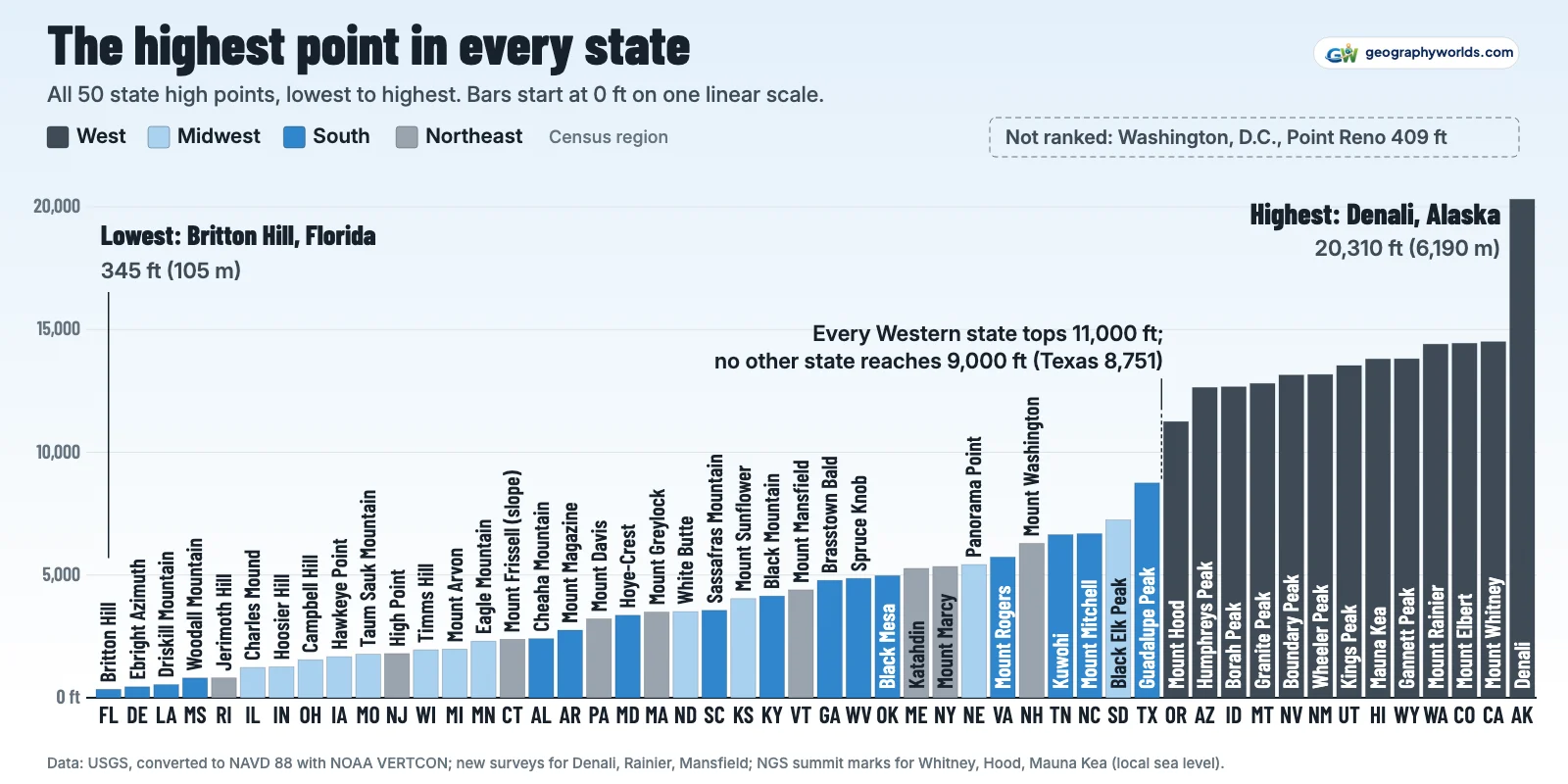
The highest point in the United States, and the highest of the 50 state high points, is Denali in Alaska at 20,310 ft (6,190 m). The lowest state high point is Britton Hill in Florida at 345 ft (105 m), so the top of the list stands 59 times as high as the bottom. In the contiguous states the highest is California's Mount Whitney at 14,505 ft, ahead of Colorado's Mount Elbert (14,440 ft) and Washington's Mount Rainier (14,406 ft). Heights are NAVD 88 feet with metres in brackets; Hawaii, outside that datum, is measured from local mean sea level. Washington, D.C. is listed but not ranked: Point Reno, its highest ground, is 409 ft.
All thirteen states of the Census Bureau's West region have a high point above 11,000 ft, and no state outside it reaches 9,000 ft. The middle of the list, the 25th and 26th states, falls between Brasstown Bald in Georgia (4,784 ft) and Mount Mansfield in Vermont (4,395 ft).
All 50 state high points, ranked
| Rank | State | Highest point | Feet | Metres | Figure from |
|---|---|---|---|---|---|
| 1 | Alaska | Denali | 20,310 | 6,190 | USGS-led GPS survey |
| 2 | California | Mount Whitney | 14,505 | 4,421 | NGS summit station WHITNEY |
| 3 | Colorado | Mount Elbert | 14,440 | 4,401 | USGS 14,433 ft + VERTCON |
| 4 | Washington | Mount Rainier | 14,406 | 4,391 | 2024 GPS survey (preprint) |
| 5 | Wyoming | Gannett Peak | 13,810 | 4,209 | USGS 13,804 ft + VERTCON |
| 6 | Hawaii | Mauna Kea (Puʻu Wēkiu) | 13,803 | 4,207 | NGS summit station SUMMIT |
| 7 | Utah | Kings Peak | 13,534 | 4,125 | USGS 13,528 ft + VERTCON |
| 8 | New Mexico | Wheeler Peak | 13,167 | 4,013 | USGS 13,161 ft + VERTCON |
| 9 | Nevada | Boundary Peak | 13,146 | 4,007 | USGS 13,140 ft + VERTCON |
| 10 | Montana | Granite Peak | 12,804 | 3,903 | USGS 12,799 ft + VERTCON |
| 11 | Idaho | Borah Peak | 12,667 | 3,861 | USGS 12,662 ft + VERTCON |
| 12 | Arizona | Humphreys Peak | 12,638 | 3,852 | USGS 12,633 ft + VERTCON |
| 13 | Oregon | Mount Hood | 11,250 | 3,429 | NGS station MOUNT HOOD HIGHEST POINT |
| 14 | Texas | Guadalupe Peak | 8,751 | 2,667 | USGS 8,749 ft + VERTCON |
| 15 | South Dakota | Black Elk Peak | 7,244 | 2,208 | USGS 7,242 ft + VERTCON |
| 16 | North Carolina | Mount Mitchell | 6,683 | 2,037 | USGS 6,684 ft + VERTCON |
| 17 | Tennessee | Kuwohi | 6,643 | 2,025 | USGS 6,643 ft + VERTCON |
| 18 | New Hampshire | Mount Washington | 6,287 | 1,916 | USGS 6,288 ft + VERTCON |
| 19 | Virginia | Mount Rogers | 5,729 | 1,746 | USGS 5,729 ft + VERTCON |
| 20 | Nebraska | Panorama Point | 5,427 | 1,654 | USGS 5,424 ft + VERTCON |
| 21 | New York | Mount Marcy | 5,344 | 1,629 | USGS 5,344 ft + VERTCON |
| 22 | Maine | Katahdin | 5,268 | 1,606 | USGS 5,268 ft + VERTCON |
| 23 | Oklahoma | Black Mesa | 4,975 | 1,516 | USGS 4,973 ft + VERTCON |
| 24 | West Virginia | Spruce Knob | 4,863 | 1,482 | USGS 4,863 ft + VERTCON |
| 25 | Georgia | Brasstown Bald | 4,784 | 1,458 | USGS 4,784 ft + VERTCON |
| 26 | Vermont | Mount Mansfield | 4,395 | 1,340 | NGS station MT MANSFIELD HIGHEST POINT |
| 27 | Kentucky | Black Mountain | 4,145 | 1,263 | USGS 4,145 ft + VERTCON |
| 28 | Kansas | Mount Sunflower | 4,041 | 1,232 | USGS 4,039 ft + VERTCON |
| 29 | South Carolina | Sassafras Mountain | 3,560 | 1,085 | USGS 3,560 ft + VERTCON |
| 30 | North Dakota | White Butte | 3,508 | 1,069 | USGS 3,506 ft + VERTCON |
| 31 | Massachusetts | Mount Greylock | 3,491 | 1,064 | USGS 3,491 ft + VERTCON |
| 32 | Maryland | Hoye-Crest (Backbone Mountain) | 3,360 | 1,024 | USGS 3,360 ft + VERTCON |
| 33 | Pennsylvania | Mount Davis | 3,213 | 979 | USGS 3,213 ft + VERTCON |
| 34 | Arkansas | Mount Magazine | 2,753 | 839 | USGS 2,753 ft + VERTCON |
| 35 | Alabama | Cheaha Mountain | 2,407 | 734 | USGS 2,407 ft + VERTCON |
| 36 | Connecticut | Mount Frissell (south slope) | 2,379 | 725 | USGS 2,380 ft + VERTCON |
| 37 | Minnesota | Eagle Mountain | 2,302 | 702 | USGS 2,301 ft + VERTCON |
| 38 | Michigan | Mount Arvon | 1,979 | 603 | USGS 1,979 ft + VERTCON |
| 39 | Wisconsin | Timms Hill | 1,951 | 595 | USGS 1,951 ft + VERTCON |
| 40 | New Jersey | High Point | 1,802 | 549 | USGS 1,803 ft + VERTCON |
| 41 | Missouri | Taum Sauk Mountain | 1,772 | 540 | USGS 1,772 ft + VERTCON |
| 42 | Iowa | Hawkeye Point | 1,671 | 509 | USGS 1,670 ft + VERTCON |
| 43 | Ohio | Campbell Hill | 1,549 | 472 | USGS 1,550 ft + VERTCON |
| 44 | Indiana | Hoosier Hill | 1,257 | 383 | USGS 1,257 ft + VERTCON |
| 45 | Illinois | Charles Mound | 1,235 | 376 | USGS 1,235 ft + VERTCON |
| 46 | Rhode Island | Jerimoth Hill | 811 | 247 | USGS 812 ft + VERTCON |
| 47 | Mississippi | Woodall Mountain | 806 | 246 | USGS 806 ft + VERTCON |
| 48 | Louisiana | Driskill Mountain | 535 | 163 | USGS 535 ft + VERTCON |
| 49 | Delaware | Ebright Azimuth | 447 | 136 | DGS benchmark 447.85 ft + VERTCON |
| 50 | Florida | Britton Hill | 345 | 105 | USGS 345 ft + VERTCON |
| — | Washington, D.C. (not ranked) | Point Reno | 409 | 125 | USGS 410 ft + VERTCON |
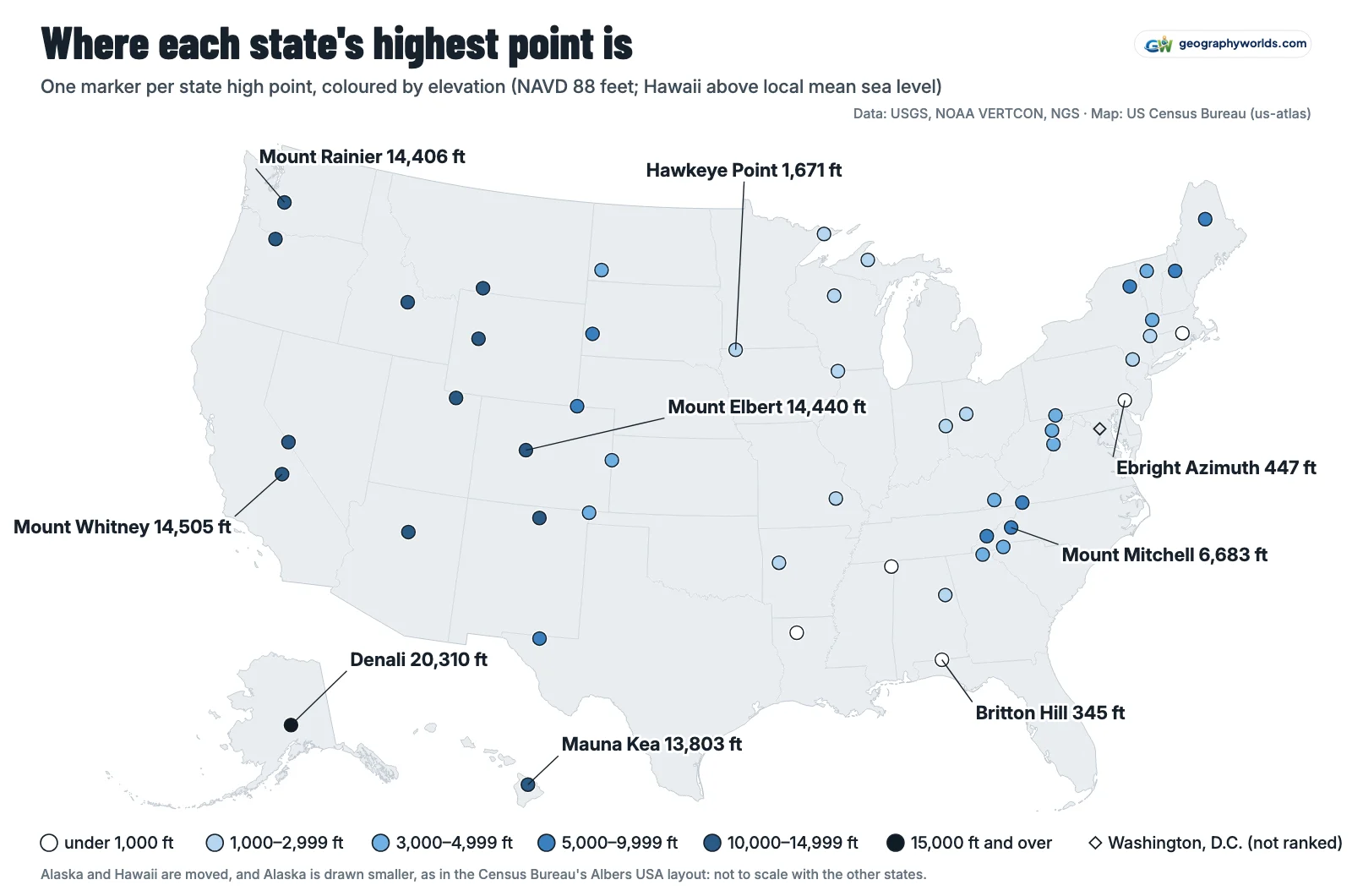
Thirteen Western states above 11,000 feet
The Rocky Mountain and Pacific states take the top 13 places. Oregon's Mount Hood, at 11,250 ft the lowest of the Western high points, still stands 2,499 ft above Texas's Guadalupe Peak (8,751 ft), the highest point anywhere else.
Four states clear 14,000 ft. After Denali, Whitney is 65 ft above Elbert, and Elbert 34 ft above Rainier, which has lost height lately. A 2024 GPS survey led by Eric Gilbertson, posted as a preprint, found that Columbia Crest, the ice dome long treated as the summit, had melted 21.8 ft since 1998, leaving the highest ground on rock on the crater's Southwest Rim at 14,406.2 ft. It is not an official figure: the National Park Service still gives 14,410 ft, and the USGS table's 14,411 ft converts to 14,418 ft. Rainier is fourth on any of them.
Wyoming's Gannett Peak (13,810 ft) leads Hawaii's Mauna Kea (13,803 ft) by 7 ft, too small a gap to call when one is measured from NAVD 88 and the other from Hawaii's local sea level. Utah's Kings Peak (13,534 ft), New Mexico's Wheeler Peak (13,167 ft), Nevada's Boundary Peak (13,146 ft), Montana's Granite Peak (12,804 ft), Idaho's Borah Peak (12,667 ft) and Arizona's Humphreys Peak (12,638 ft) follow. All eight states of the Census Bureau's Mountain division, the country of the Rocky Mountains and the Great Basin, top 12,000 ft, and they hold eight of the ten highest state high points outside Alaska and California.
The Appalachian chain, from Katahdin to Cheaha
East of the Mississippi the highest point is North Carolina's Mount Mitchell at 6,683 ft (2,037 m), with Tennessee's Kuwohi 40 ft behind at 6,643 ft. Kuwohi, the USGS table's Clingmans Dome, got its Cherokee name back when the Board on Geographic Names ruled in September 2024. Mitchell ranks only 16th nationally, behind every Western state, Texas and South Dakota.
Sixteen states take their high point from the Appalachians, and five of them pass 5,000 ft: North Carolina, Tennessee, New Hampshire (Mount Washington, 6,287 ft), Virginia (Mount Rogers, 5,729 ft) and Maine (Katahdin, 5,268 ft). New York's Mount Marcy (5,344 ft) also clears that mark, but it stands in the Adirondacks, a separate upland, so it is not counted here. The chain crests in North Carolina and falls away into Alabama, where Cheaha Mountain reaches 2,407 ft.
Elsewhere the chain is far lower. Maryland's Hoye-Crest on Backbone Mountain is 3,360 ft and Pennsylvania's Mount Davis 3,213 ft; Massachusetts tops out on Mount Greylock at 3,491 ft and Vermont on Mount Mansfield at 4,395 ft.
Plains high points at the western fence line
The six Great Plains states share a pattern: each one's highest ground sits near its western edge, on the side facing the Rockies. Every one lies in the westernmost 14% of its state's width; Texas's is the furthest in. Nebraska's Panorama Point (5,427 ft) is 1.2 miles from the state's western boundary, and Kansas's Mount Sunflower (4,041 ft) and Oklahoma's Black Mesa (4,975 ft) each sit within about a mile of theirs.
These are some of the highest state high points outside the West. Mount Sunflower stands higher than the high point of every New England state except New Hampshire, Maine and Vermont. North Dakota's White Butte (3,508 ft) and South Dakota's Black Elk Peak (7,244 ft), the USGS table's Harney Peak, round out the group; Black Elk Peak, in the Black Hills, ranks 15th, one place behind Texas.
Midwest summits in fields, farms and backyards
Further east, none of the eight states from Minnesota to Ohio reaches 2,400 ft. Minnesota's Eagle Mountain (2,302 ft) is the highest, followed by Michigan's Mount Arvon (1,979 ft), Wisconsin's Timms Hill (1,951 ft) and Missouri's Taum Sauk Mountain (1,772 ft). Iowa's Hawkeye Point (1,671 ft) is a rise in farmland, as the photograph below shows, Ohio's Campbell Hill reaches 1,549 ft, and Indiana's Hoosier Hill (1,257 ft) and Illinois's Charles Mound (1,235 ft) rank 44th and 45th.

Relief is small too: on the USGS table's low points, Iowa spans 1,191 ft, Ohio 1,094 ft, Illinois 956 ft and Indiana 937 ft. Colorado's lowest point, on the Arikaree River in Yuma County, is 3,315 ft in the USGS table, 3,317 ft on NAVD 88, and eighteen states never get that high at all. The nearest miss is Pennsylvania's Mount Davis, 104 ft short, while Maryland's Hoye-Crest clears it by only 43 ft.
Where the coastal plain tops out below 1,000 feet
Five states have no ground above 1,000 ft: Rhode Island (Jerimoth Hill, 811 ft), Mississippi (Woodall Mountain, 806 ft), Louisiana (Driskill Mountain, 535 ft), Delaware (Ebright Azimuth, 447 ft) and Florida. Rhode Island and Mississippi are almost level, 5 ft apart. Delaware's figure starts from the benchmark on Ebright Road, 447.85 ft according to the Delaware Geological Survey; that height predates NAVD 88, and converted it is 447 ft. The DGS adds that NGS and DGS surveys and 2007 lidar put the actual highest ground, just west of the road, about 2 ft higher. Either way Delaware is 49th.

Britton Hill, in Florida's Walton County, is 345 ft above sea level, and VISIT FLORIDA markets it as the country's lowest high point. Washington, D.C. is not a state and is not ranked, but Point Reno beats Florida by 64 ft: the capital's highest ground is higher than an entire state's.
Record holders at the top and bottom
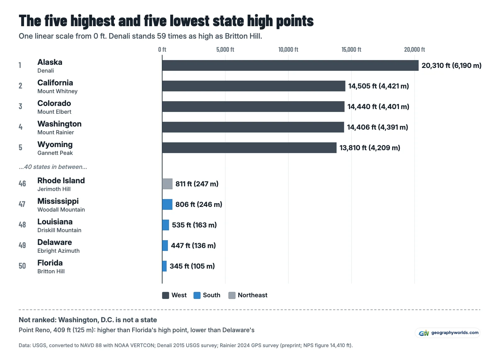
Denali's 20,310 ft comes from a USGS-led GPS survey announced on 2 September 2015, which replaced the 20,320 ft figure from 1950s surveys that the USGS table still prints. Its federal name has changed twice in a decade: Mount McKinley became Denali in 2015, and Secretarial Order 3424 reinstated Mount McKinley in 2025 while keeping Denali National Park's name. With sea level as its lowest ground, Alaska spans 20,310 ft; California, from Death Valley at −282 ft to Whitney, spans 14,787 ft, more than any state but Alaska. Denali is also North America's highest summit, as our ranking of every country's highest mountain shows.
How every height was measured
The starting point is the USGS table "Highest and Lowest Elevations", which gives every state's high point from 7.5-minute topographic maps. Those maps use the 1929 datum (NGVD 29), modern surveys NAVD 88. We moved the figures for 43 states and DC to NAVD 88 with NOAA's VERTCON conversion at the summit's coordinates. The shift is under a foot across most of the East and grows westward to 6.6 ft in Washington.
Three states have a newer measurement of the summit: Denali (2015), Rainier (the 2024 preprint) and Mount Mansfield, where NGS levelled its highest-point station with GPS. For three more we use NGS's own height for the survey mark on the summit instead of the map figure. Whitney's station is 14,498 ft on the old datum (the table prints 14,494) and 14,505 ft on NAVD 88; Hood's station, named as its highest point, is 11,250 ft against the table's 11,239. Mauna Kea's 13,803 ft is NGS's height for a summit disk stamped 13,796, the table's figure. Delaware's benchmark is converted like the rest.
We checked the figures two more ways. Of 13 further NGS summit stations, 11 agree with ours within 3 ft, which mostly confirms the conversion, since NGS converted most of them the same way; the exceptions are Cheaha, where an NGS chiselled cross gives 2,413 ft, and Mount Rogers, where an NGS disk height derived from 1993 GPS gives 5,711 ft, 18 ft below the map figure. Wikipedia's NAVD 88 list matches ours within 3 ft for 43 states; Virginia, Maryland, Washington, Connecticut, Kentucky, South Carolina and Nebraska differ by 5 to 18 ft. On every one of these alternative sets, and on the USGS table as printed, the order of all 50 states is the same.
The spreadsheet has every state's USGS figure, VERTCON shift, comparisons, coordinates and the reason for each replacement; download the data as a CSV. In Parity, those columns become a chart of any states you pick. Sources:
- USGS, Elevations and Distances in the United States: Highest and Lowest Elevations: high and low point of every state and DC, online edition revised 2005; US government work, public domain
- NOAA National Geodetic Survey, NCAT coordinate conversion tool (VERTCON 3.0, NGVD 29 to NAVD 88): datum shift at each summit, queried point by point through the NCAT API on 16 October 2026; public domain
- NOAA National Geodetic Survey datasheets (summit stations): heights of NGS stations on or near 17 high points, read through the NGS Data Explorer API; public domain
- USGS news release, 'New Elevation for Nation's Highest Peak' (2 September 2015): Denali 20,310 ft; public domain
- Eric Gilbertson, Larry Signani and Kathryn Stanchak, 'Mount Rainier Elevation Survey 2024', arXiv:2512.01130 (preprint): Rainier's summit moved to the Southwest Rim, 14,406.2 ft NAVD 88; figure quoted, not an official figure
- National Park Service, Mount Rainier National Park: official summit height 14,410 ft; figure quoted
- Delaware Geological Survey, 'Highest point in Delaware': Ebright Azimuth benchmark 447.85 ft (a pre-NAVD 88 height, converted with VERTCON); figure quoted
- Wikidata: highest point (P610) of each state, with coordinates (P625): queried 16 October 2026; CC0
- US Census Bureau, Census Regions and Divisions of the United States: region of each state; public domain
- us-atlas 3.0.1 (US Census Bureau cartographic boundaries): state outlines for the map; boundaries public domain, package ISC
- Wikipedia, 'List of U.S. states and territories by elevation': used only as a cross-check of every figure; not republished
For Denali set against Canada's Mount Logan and Mexico's Pico de Orizaba, and the story of its first ascent, see our guide to the highest mountain in North America.