

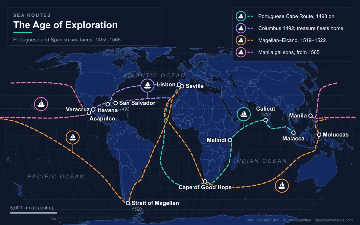
The Age of Exploration, also called the Age of Discovery, is the period from about 1450 to about 1620 when Portuguese and Spanish sailors, followed by the Dutch, English and French, opened sea routes that linked Europe, Africa, the Americas and Asia for the first time. Its main routes were the Portuguese Cape Route around Africa to India (1498), the Spanish Atlantic crossings to the Caribbean and Mexico (from 1492), the Strait of Magellan (1520) and the Manila galleon route across the Pacific (1565). The system peaked around 1580, when Philip II of Spain also became king of Portugal and a single crown ruled lanes from Lisbon and Seville to Goa, Malacca, Manila, Acapulco and Potosí. Silver, spices, silk, sugar and enslaved Africans moved along these routes, and so did the diseases that killed most of the Indigenous population of the Americas. The age began the global trade system and Europe's colonial empires, and it faded as Dutch and English companies broke the Iberian monopolies.
Ceuta, Caravels and Cape Bojador: Why Iberia Took to the Ocean (1415–1494)
Three pressures pushed Portugal and Castile out into the Atlantic. The first was the middlemen. Asian spices and silks reached Europe through the Levant and Egypt, where Venice and Genoa held the European end of the trade, and the Ottoman capture of Constantinople in 1453 was a further blow to Christian Europe’s commercial links with the East. The second was a shortage of bullion: Europe's gold and silver flowed east to pay for these goods, several European mines were exhausted, and the shortage drove the growth of banking, beginning with Genoa’s Banco di San Giorgio in 1407. The third was crusading ambition. In 1415 John I of Portugal took Ceuta, across the Strait of Gibraltar, with a fleet of about 200 ships carrying as many as 50,000 men, and his son Prince Henry, later called the Navigator, began sending expeditions down the African coast from 1418.
Technology made the push possible. From 1440 the Portuguese used the caravel, a light, shallow-draught ship with a sternpost rudder that could work to windward along an unknown coast. Columbus later re-rigged the Niña with square sails for the run across the Atlantic. Tables of star positions, such as the Almanac Perpetuum published by Abraham Zacuto in 1496, let pilots calculate latitude, though longitude stayed out of reach for centuries. The tradition that Henry ran a school of navigators at Sagres is now regarded by historians as a myth; he did employ cartographers to chart the African coast.
Progress was slow at first. Henry's captain Gil Eanes passed Cape Bojador, in present-day Western Sahara, only in 1434. Senegal and Cape Verde were reached in 1445, and the Gulf of Guinea in the 1460s. In 1482 Portugal built São Jorge da Mina (Elmina Castle) on the Gold Coast, the first European trading post on the Gulf of Guinea. Bartolomeu Dias rounded the Cape of Good Hope in 1488.

Papal bulls gave the Iberian crowns a legal claim to whatever they found. Romanus Pontifex in 1455 granted Portugal the lands and seas beyond Cape Bojador. After Columbus's first voyage, the 1494 Treaty of Tordesillas divided the world outside Europe along a line 370 leagues west of the Cape Verde Islands: lands to the east went to Portugal and lands to the west to Castile. England, France and the Netherlands never recognised it.
1492 to 1522: Columbus, da Gama and the Victoria Open Three Oceans
Funded by the Catholic Monarchs Ferdinand and Isabella in the year they conquered Granada, Christopher Columbus left Palos de la Frontera on 3 August 1492 and sighted land in the Bahamas on 12 October. Portugal had twice rejected his plan, in 1485 and 1488, because its experts rightly judged his estimate of 2,400 miles (3,860 km) to Asia far too short. Vasco da Gama left Lisbon on 8 July 1497 and reached Kozhikode (Calicut) in India on 20 May 1498, after more than three months and over 10,000 km on the open ocean without sighting land, the longest such passage then made. In 1500 Pedro Álvares Cabral, bound for India, swung far west and landed in Brazil, which lay on Portugal's side of the Tordesillas line.
The Pacific followed. Vasco Núñez de Balboa crossed the Isthmus of Panama in 1513 and saw the "other sea". Ferdinand Magellan, a Portuguese navigator sailing for Charles I of Spain, left Seville on 10 August 1519 with five ships and about 237 men. The fleet passed through the 600 km strait that now bears his name between 21 October and 28 November 1520. Magellan was killed at the Battle of Mactan in the Philippines, and Juan Sebastián Elcano brought the last ship, the Victoria, home to Spain on 6 September 1522, completing the first circumnavigation.
The two crowns then argued over where the Tordesillas line fell on the far side of the globe, since both claimed the clove-producing Moluccas. The 1529 Treaty of Zaragoza settled it in Portugal's favour, with Portugal paying Charles V 350,000 gold ducats. By then the Spanish had conquered the Aztec Empire (1519–1521) and in 1532 Francisco Pizarro would begin the conquest of the Inca Empire.
Potosí Silver, the Manila Galleon and the Iberian Union: The Peak Around 1580
The routes reached their fullest extent in the third quarter of the 16th century. In 1545 silver was found at the Cerro Rico above Potosí in present-day Bolivia, and in the second half of the century that one mountain produced an estimated 60 percent of all the silver mined in the world. The town grew to more than 200,000 people. Under the mita forced-labour system, about 13,000 Indigenous men were conscripted each year, about one in seven adult men in the region. Between 1500 and 1800 Mexico and Peru produced about 80 percent of the world's silver.

That silver tied the oceans together. From 1566 the Spanish treasure fleets sailed in convoy between the Caribbean and Seville, where the Casa de Contratación held a legal monopoly on colonial trade. In 1565 Andrés de Urdaneta found a way back across the Pacific by sailing north to about 38° N to pick up westerly winds, reaching Acapulco on 8 October after 130 days and about 19,000 km. His route carried the Manila galleons, which took American silver to Manila to buy Chinese silk and porcelain; more than 30 percent of the world's silver output eventually ended up in China. One galleon is recorded carrying more than 50,000 pairs of silk stockings. On the Portuguese side, 1,033 ships sailed from Lisbon on the Carreira da Índia between 1497 and 1650. Portuguese traders reached Japan in 1543, and in 1557 the Ming court allowed them to settle at Macau.
The human cost was enormous. Eurasian diseases, war and forced labour killed an estimated 50 to 90 percent of the Indigenous population in parts of the Americas. To replace that labour, Europeans turned to Africa: about 12.75 million Africans were loaded onto slave ships for the Americas over the whole history of the Atlantic slave trade, and up to 2 million died on the crossing. Portugal was the largest slave-trading nation by volume. The Columbian exchange also moved maize and manioc to Africa, sweet potatoes and peanuts to China and cattle, horses and sheep to the Americas.
The high point came in 1580, when Philip II of Spain inherited the Portuguese crown. Although the two empires were run separately, a single monarch now held the Atlantic, Indian Ocean and Pacific routes at once.
Spanish Defaults, Antwerp's Fall and Dutch Fleets: How the Iberian Age Ended (1557–1641)
The decline began inside the boom. American silver flooding into Europe fed a long inflation, the price revolution, which hurt Spanish industry. Philip II spent heavily on war and defaulted on his debts in 1557, 1560, 1575 and 1596. The Dutch revolt against him from 1568 started the Eighty Years' War, and when Spanish troops took Antwerp, then the most important port in the world, in 1585, its Protestant merchants and craftsmen moved north and turned Amsterdam into a commercial centre. In 1588 an English fleet, in which Francis Drake played a major role, defeated the Spanish Armada.
The Iberian union of crowns also made Portugal's eastern posts targets for Spain's enemies. In 1592 Cornelis de Houtman gathered intelligence in Lisbon, and Jan Huyghen van Linschoten published sailing directions to the East Indies in Amsterdam; Houtman then led the first Dutch voyage to the East Indies, which found a new route from Madagascar to the Sunda Strait and secured a treaty with the Sultan of Banten on Java. England chartered its East India Company in 1600 and the Dutch the VOC in 1602, and Dutch, English and French ships flouted the century-old Portuguese monopoly on the Cape Route, whose scattered coastal forts could not defend so vast a network. The Dutch took Elmina in 1637 and Malacca in 1641. The Age of Exploration is usually dated to end around 1620, by which time the routes were known and the contest had become one of trading companies and colonial wars. The Spanish treasure fleets continued until 1790 and the Manila galleons until 1815.
For the human trade that grew out of these voyages, read our guide to the Atlantic slave trade routes; for the passage that opened the Pacific, see the Strait of Magellan, and for the northern sea route that English and Dutch explorers searched for in vain, our Northwest Passage guide.