
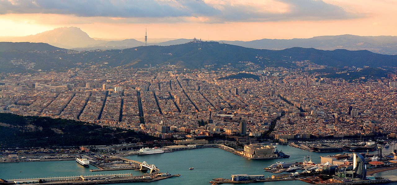
Barcelona, the capital of Catalonia and Spain's second-largest city, occupies a narrow coastal plain on the northeastern Iberian Peninsula, wedged between the Mediterranean Sea to the east and the Collserola mountain range to the west. The city is bounded by two rivers—the Besòs to the north and the Llobregat to the south—creating a naturally defined urban footprint.
Introduction
This compact geography, covering roughly 101 km² within the city limits and home to about 1.6 million people (5.5 million in the metropolitan area), has produced one of the most densely built cities in Europe. The interplay of mountain, plain, and sea gives Barcelona its distinctive character and microclimates.
Location & Setting
- Coordinates: 41.3874°N, 2.1686°E
- Elevation Range: 0–512 m (Tibidabo)
- Area: 101 km² (city proper)
- Country: Spain
Barcelona sits on the Pla de Barcelona, a gently tilted plain that slopes from the Collserola ridge (512 m at Tibidabo) down to the Mediterranean shore. The plain is roughly 5 km wide and 10 km long, bounded by the Besòs river valley to the northeast and the Llobregat delta to the southwest.
The city's coastline stretches roughly 4.5 km along sandy beaches that are largely artificial, created in the 1990s when Barcelona's industrial waterfront was transformed for the 1992 Olympic Games. Offshore, the continental shelf is narrow, and the Mediterranean reaches depths of over 2,000 meters within 100 km of the coast.
Terrain & Landscape
- Collserola Ridge: Forested mountain range, 512 m at Tibidabo
- Montjuïc: Prominent hill, 173 m, overlooking the harbor
- Barcelona Plain: Gently sloping coastal plain
- Llobregat Delta: Wetland area south of the city, important bird habitat
The Collserola ridge forms Barcelona's natural western boundary, a forested barrier that separates the coastal plain from the Vallès region inland. The Serra de Collserola Natural Park covers over 8,000 hectares of Mediterranean woodland and provides the city with green space, fresh air, and hiking trails within minutes of the urban center.
Montjuïc, a prominent hill (173 m) on the southwestern edge of the city overlooking the port, is Barcelona's other major topographic feature. The hill is composed of red sandstone (from which it gets its distinctive color) and has served as a fortress, cemetery, and now a park and cultural complex. The Llobregat Delta, at the southern edge of the metropolitan area, is a significant wetland that supports over 350 bird species despite being surrounded by the airport, industrial zones, and agriculture.
Climate & Weather
- Climate Type: Mediterranean (Köppen Csa)
- Average Summer Temp: 24–30°C
- Average Winter Temp: 5–13°C
- Annual Rainfall: ~600 mm
Barcelona has a classic Mediterranean climate with hot, dry summers and mild, relatively wet winters. The city benefits from the moderating influence of the Mediterranean Sea, which keeps summer temperatures lower and winter temperatures higher than inland Catalonia. Sea breezes provide natural cooling in summer, though heat waves can push temperatures above 35°C.
Rainfall is concentrated in autumn, when intense convective storms (known locally as gota fría or DANA events) can dump months’ worth of rain in hours, causing flash flooding in the city's streets and underpasses. Barcelona experiences roughly 55 rainy days per year, and summer drought is common, occasionally leading to water restrictions. The city has invested in desalination and water recycling to manage chronic water scarcity.
Hydrology & Water
- Besòs River: Northern boundary, 17.7 km, heavily urbanized
- Llobregat River: Southern boundary, 170 km, major water source
- Aquifer: Llobregat delta aquifer, historically overexploited
- Desalination: El Prat plant, one of Europe's largest
Barcelona's two rivers—the Besòs and the Llobregat—define the city's northern and southern limits but are modest in size and flow. Both were heavily polluted by industrial activity in the 20th century; the Besòs was once called the most polluted river in Europe. Major cleanup efforts since the 1990s have restored both rivers to the point where fish and bird life have returned.
Water scarcity is Barcelona's most significant ongoing geographic challenge. The city relies on the Llobregat and Ter rivers, desalination, and groundwater, but demand from over 5 million metropolitan residents strains supplies, especially during summer droughts. The 2008 drought was so severe that Barcelona briefly imported emergency water by ship from southern France. The El Prat desalination plant, opened in 2009, can produce 200,000 m³ of drinking water per day.
Coastal Geography
- Coastline: ~4.5 km of city beaches
- Port of Barcelona: Major Mediterranean cruise and cargo port
- Beach Origin: Artificial beaches created for the 1992 Olympics
- Offshore: Continental shelf narrows rapidly to deep Mediterranean
Barcelona's coastline was fundamentally transformed for the 1992 Olympic Games. Before the Olympics, the waterfront was an industrial zone of railways, factories, and warehouses that cut the city off from the sea. The Olympic redevelopment demolished these barriers, created sandy beaches, and opened a promenade that is now one of the most popular public spaces in the city.
The Port of Barcelona is one of the busiest in the Mediterranean, handling over 3 million cruise passengers and significant container traffic annually. The port sits in the natural shelter of Montjuïc hill, which provides protection from southwesterly winds. Rising sea levels and increased storm intensity pose future risks to Barcelona's low-lying coastal areas and delta.
Key Facts
- Barcelona occupies a 101 km² coastal plain between the Collserola mountains (512 m) and the Mediterranean Sea.
- The city's beaches are largely artificial, created for the 1992 Olympic Games.
- Annual rainfall is only ~600 mm, and water scarcity is a chronic challenge for the metropolitan area.
- The Llobregat Delta supports over 350 bird species despite being surrounded by urban and industrial development.
- The Collserola Natural Park provides over 8,000 hectares of forested green space adjacent to the city.
Fun Facts
- Barcelona imported emergency drinking water by ship from France during the severe 2008 drought.
- The Besòs River was once called the most polluted river in Europe before major restoration efforts.
- Flash floods from Mediterranean storms can dump months’ worth of rain on Barcelona in a single day.
- Montjuïc's red sandstone gives the hill its distinctive color; it was quarried for building material for centuries.
Final Thoughts
Barcelona's geography is defined by compression—a dense city squeezed onto a narrow coastal plain between mountains and sea, bounded by two rivers. This compact setting has produced one of Europe's most walkable and vibrant urban environments, but it also concentrates the city's geographic challenges: water scarcity, flash flood risk, and limited space for expansion. The transformation of Barcelona's industrial waterfront into a beach city for the 1992 Olympics stands as one of the great urban-geographic reinventions of modern times.
Test Your Knowledge!
Think you know world city geography? Test your knowledge with our interactive games!
Play Geography Games →