

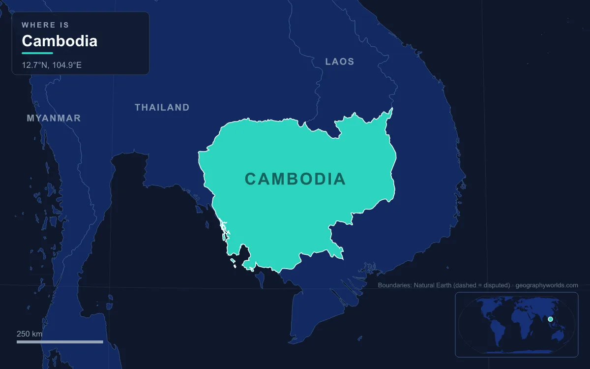
Cambodia is a country of 181,035 km² in the southwest of mainland Southeast Asia, bordered by Thailand, Laos and Vietnam and facing the Gulf of Thailand along roughly 440 km of coast. Its shape is often compared to a bowl. About three-quarters of the country is the low central plain of the Tonlé Sap basin, the Mekong and the Bassac River, and around it rise the walls: the Dângrêk escarpment in the north, the Annamite foothills and eastern highlands in the northeast, and the Cardamom and Elephant mountains in the southwest and south. The highest point is Phnom Aural in the Cardamoms, at about 1,810 m; the lowest is sea level on the Gulf. The Mekong, which flows 486 km through the country, is the longest river, and the Tonlé Sap is the largest freshwater lake in Southeast Asia. Of about 17 million Cambodians, two-thirds live on the lowlands, where the river's annual floods leave the soil that grows the rice. The clearest way to understand the country is to cross it one region at a time, starting on the floor of the bowl.
The Central Plain and the Tonlé Sap, the Lake That Breathes
The interconnected flood plain at Cambodia's centre is a geologically young depression where the Mekong and its tributaries drop their sediment, and the Tonlé Sap lake and river occupy its lowest part. The lake's Khmer name means "fresh river", though in English it is usually called the Great Lake. Its story begins at the end of the last ice age, when the lower Mekong plain was a bay of the sea. Sediment cores near Angkor contain tidal, salt-marsh and mangrove deposits laid down about 7,900 to 7,300 years ago. As the Mekong built its delta over the following 6,000 years, the water left behind in the northwest corner of the plain became the Tonlé Sap.
What makes the lake unique is that its outlet runs in both directions. The Tonlé Sap River, about 115 km long, links the lake to the Mekong at Phnom Penh. From May or June, when melting snow far upstream and monsoon rain swell the Mekong, water pushes up the river into the lake, peaking at around 10,000 m³ per second in late August. In October or November, as the Mekong falls below the level of the flooded lake, the current reverses and the lake drains back out. The mean volume that flows backwards each year is about 30 km³, roughly half of the lake's maximum volume.
The result is a lake that changes size almost tenfold. At the end of the dry season in April it covers around 2,700 km² and is about 1 m deep; by October or November it spreads over about 26,000 km² and reaches depths of up to 9 m. In 2000, one of the worst floods on record pushed it to about 45,000 km² and caused more than 800 deaths in Cambodia and Vietnam. Its drainage basin covers 86,000 km², bounded by the Cardamoms to the southwest. Flooded forest, fish and floating villages all depend on this pulse, and UNESCO designated the lake a Biosphere Reserve in 1997. The site's Tonlé Sap geography guide looks at the lake's ecology in more depth.
The plain's soils are less generous than its water. Sandstone underlies much of the country, and Acrisols, weathered and low in nutrients, cover nearly half of the land area. Wet-rice farming has therefore clustered where the floods renew the ground each year, with sugar palms, coconut trees and banana groves fringing the paddies, while natural vegetation survives mainly on higher ground and along waterways.
The Mekong Corridor From Stung Treng to Phnom Penh
The Mekong is the axis of the country. It is about 4,909 km long in total, with a drainage area of 795,000 km², and by the time it crosses into Cambodia at Stung Treng Province over 95 percent of its water has already joined it. Upstream in Laos it tumbles through rapids and cataracts. Once inside Cambodia it becomes calm, widens across the lowlands and stays navigable all year, flowing south past Kratie toward the capital.

Phnom Penh sits at the most important junction on the river. Here the Tonlé Sap River joins the Mekong, and here the Bassac River begins. The city was founded in 1372, served as capital from 1434 to 1497 after the fall of Angkor, and has been the national capital again since 1865. Below it the Mekong divides into several arms and enters Vietnam south of the Koh Thom and Loek Daek districts of Kandal Province, where the low plain continues into the Mekong Delta and out to the South China Sea.
The corridor carries the country's rhythm of seasons. The southwest monsoon brings rain from mid-May to September or early October, and the northeast monsoon brings drier, cooler air from November to March. Across the Tonlé Sap basin temperatures hardly change, with an annual mean near 25 °C, though readings above 38 °C are possible just before the rains, and May is usually the warmest month. More on the river's full course, from Tibet to the delta, is in the site's Mekong River guide.
The Dângrêk Escarpment on the Thai Border
Cambodia's northern wall is the Dângrêk range, a forested line of sandstone hills averaging 450 to 600 m that runs about 320 km westward from the Mekong. It is really the southern edge of the Khorat Plateau of northeastern Thailand. On the Thai side the land slopes gently north toward the Mun River; on the Cambodian side it drops abruptly to the plain. The highest point is 761 m. The watershed along the escarpment marks most of the border between the two countries, though not everywhere, and dry evergreen and dipterocarp forests cover the slopes, with illegal logging and dry-season fires stripping some stretches.
The escarpment's sharpest point holds Prasat Preah Vihear, a Khmer temple built on top of Poy Tadi, a cliff about 525 m high. Unusually for a Khmer temple, it runs for 800 m along a north–south axis, climbing from the plateau toward the edge of the drop. The international border cuts it off from the plains to the north, and its ownership was disputed for decades. The International Court of Justice ruled in 1962 that the temple lies in Cambodia, UNESCO listed it as a World Heritage Site on 7 July 2008, and a further ICJ ruling in 2013, after renewed tension, again found in Cambodia's favour.

Ratanakiri, Mondulkiri and the Annamite Foothills
East of the Mekong the bowl's rim is formed by the foothills of the Annamite Range, which continue across the border into the Central Highlands of Vietnam. Cambodia's northernmost and easternmost points both lie in Ratanakiri Province, in Ta Veaeng and Ou Ya Dav districts. In Mondulkiri, to the south, transitional plains climb into the eastern highlands at 200 to 1,000 m, covered in tall grass and deciduous forest.
The wider Greater Annamites ecoregion is among the last relatively intact moist forests in Indochina. Annual rainfall ranges from 1,500 to 3,850 mm, mean temperatures are about 20 °C, and moisture blowing in from the Gulf of Tonkin keeps the air humid. More than 30 Indigenous groups live across the Annamites, each with its own language and customs. In Cambodia, Mondulkiri and Ratanakiri had the country's highest fertility rates in surveys around 2010, at about 4.5 children per woman. Rubber plantations, logging and especially mining have cut into the landscape in recent decades, though sizeable areas of forest survive.
The Cardamom and Elephant Mountains and the Gulf of Thailand Coast
The southwest is Cambodia's highest and wettest region. The Cardamom Mountains, or Krâvanh, run northwest to southeast through Koh Kong and Kampong Speu provinces and rise above 1,500 m. Phnom Aural, in Aoral District of Kampong Speu, is the summit of the country: most sources give about 1,810 to 1,813 m, though some give figures as low as 1,667 m, and the Phnom Aural Wildlife Sanctuary has protected it since 1993. Facing the southwest monsoon, the western slopes of the range receive 3,000 to 5,000 mm of rain a year, while the eastern slopes, in their rain shadow, get only 1,020 to 1,520 mm. Their remoteness has kept the Cardamom moist forests among the most species-rich and intact habitats in the region.

The Elephant Mountains, or Dâmrei, branch off toward the southeast as a chain of high hills between 500 and 1,000 m, extending about 110 km north from the Gulf of Thailand. Their high point near the sea is Mount Bokor, 1,081 m, where the French built the Bokor Hill Station as a cool retreat in the early 1920s, about 37 km west of Kampot. Between the mountains and the sea lies a narrow coastal plain with Kampong Saom Bay and the Sihanoukville peninsula.
The coast itself is shared by four provinces, Koh Kong, Sihanoukville, Kampot and Kep, and covers 17,237 km². Its length depends on who measures it: the most widely accepted figure is 440 km, a 1997 survey found 435 km, and one FAO study gave 557 km. Rivers draining the mountains carry sediment onto the shallow shelf, which supports extensive mangroves, especially in Koh Kong and Ream National Park. Offshore lie about 60 islands, 23 of them in Koh Kong, 22 in Sihanoukville, 13 in Kep and 2 in Kampot, and the country's southernmost point is the island of Koh Poulo Wai. From this rainy rim the rivers run back inland to the plain and its capital, described in the site's article on Phnom Penh.