

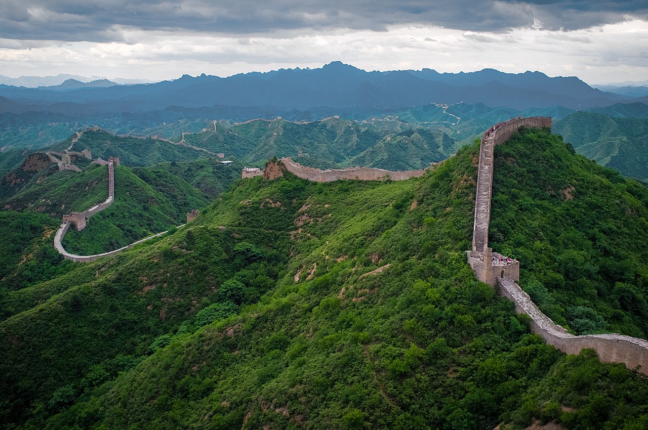
Chinese civilization was born along the Yellow River and expanded outward over four millennia, shaped at every stage by geography. The fertile plains of the Yellow and Yangtze rivers supported the world's largest agricultural populations. Mountain ranges and deserts defined the empire's boundaries. The Great Wall marked the geographic frontier between settled agriculture and nomadic pastoralism.
Introduction
Understanding Chinese dynastic geography means understanding how terrain determined political boundaries. Dynasties that controlled both the Yellow and Yangtze river basins unified "China Proper." Those that pushed into Central Asia controlled the Silk Road. Those that failed to defend the northern steppe frontier fell to nomadic invasions. Geography was the script that dynasties performed.
Geographic Context
- Yellow River: 5,464 km, "Cradle of Chinese Civilization"
- Yangtze River: 6,300 km, longest river in Asia
- Great Wall: ~21,000 km (all sections combined)
- China Proper: ~4 million km² (eastern agricultural heartland)
China's core geography is defined by two great river systems. The Yellow River (Huang He) in the north flows through loess plateau regions where windblown soil creates some of the world's most fertile farmland. The Yangtze River in the south drains a vast basin of rice paddies and subtropical agriculture. Together, these two river systems supported the densest agricultural populations in the premodern world.
The geographic boundaries of the Chinese empire were remarkably consistent across dynasties. To the east, the Pacific Ocean. To the south, tropical mountains and jungles of Southeast Asia. To the west, the Tibetan Plateau, averaging 4,500 meters elevation. To the north, the Gobi Desert and Mongolian steppe. These natural barriers defined the limits of Chinese agricultural civilization.
Key Events
- Qin Unification: 221 BC (first unified China)
- Han Dynasty Silk Road: 130 BC-220 AD
- Grand Canal: Built 605-610 AD, 1,776 km
- Qing Maximum Extent: 1790 AD, ~13 million km²
The Qin Dynasty's unification of China in 221 BC was as much a geographic achievement as a military one. Emperor Qin Shi Huang standardized weights, measures, currency, and writing across regions that had been geographically isolated for centuries. He connected existing defensive walls into the first Great Wall, establishing the geographic boundary between Chinese agriculture and steppe nomadism.
The Grand Canal, built primarily during the Sui Dynasty (605-610 AD) and extended under later dynasties, was China's most important geographic engineering project. Stretching 1,776 kilometers from Beijing to Hangzhou, it connected the Yellow and Yangtze river basins, enabling the transport of rice from the productive south to the political capital in the north. This north-south waterway unified what nature had divided.
Territorial Changes
- China Proper: ~4 million km² (consistent core)
- Tang Dynasty Peak: ~5.4 million km² (Central Asian expansion)
- Mongol Yuan: Entire China plus Mongolia, Tibet, Yunnan
- Qing Empire: ~13 million km² (largest Chinese empire)
Chinese territorial history follows a pattern dictated by geography: strong dynasties expanded from the agricultural core into Central Asia, Mongolia, Tibet, and Vietnam; weak dynasties contracted to the core river plains. The Tang Dynasty (618-907 AD) pushed deep into Central Asia, controlling the Silk Road oasis cities. The Song Dynasty (960-1279 AD), weakened by northern incursions, controlled only the southern half of China Proper.
The Qing Dynasty (1644-1912) achieved China's maximum geographic extent, incorporating Mongolia, Tibet, Xinjiang (Central Asia), Manchuria, and Taiwan into an empire of approximately 13 million square kilometers. The Qing frontier policy was explicitly geographic: controlling the steppe by incorporating it, rather than simply building walls against it. Modern China's borders largely reflect Qing geographic expansion.
Lasting Impact
- Modern Borders: PRC borders largely follow Qing boundaries
- Agricultural Zones: North wheat, south rice divide persists
- Infrastructure: Grand Canal still navigable today
The geographic pattern of Chinese agriculture, wheat and millet in the dry north, rice in the wet south, established during the early dynasties, persists to this day. The Qinling Mountains and Huai River form the traditional geographic boundary between north and south China, a line that also roughly separates Mandarin from southern Chinese dialect groups.
China's modern territorial claims, including Tibet, Xinjiang, and the South China Sea, are rooted in dynastic geographic history. The People's Republic of China explicitly identifies its territory with the Qing Empire's maximum extent, making dynastic geography a live political issue in contemporary Asian geopolitics.
Modern Relevance
- Three Gorges Dam: World's largest hydroelectric dam on the Yangtze
- Belt and Road: Modern Silk Road follows ancient routes
- Urbanization: 600 million people in Yangtze River basin
The same geographic features that shaped dynastic China continue to shape the modern nation. The Three Gorges Dam on the Yangtze, completed in 2006, is the world's largest hydroelectric facility, harnessing the same river that sustained Chinese civilization for millennia. The Yangtze River basin alone contains roughly 600 million people, more than the entire population of the European Union.
China's Belt and Road Initiative explicitly follows the geographic corridors of the ancient Silk Road, investing in infrastructure across Central Asia along routes that Chinese empires contested and controlled for over two thousand years. The geographic logic of Chinese expansion, connecting the productive heartland to the wider world through mountain passes and maritime routes, remains unchanged.
Key Facts
- The Yellow River and Yangtze River basins form the agricultural heartland of Chinese civilization.
- The Great Wall, totaling ~21,000 km across all dynasties, marked the frontier between agriculture and steppe.
- The Grand Canal (1,776 km) connected the Yellow and Yangtze basins, unifying north and south China.
- The Qing Dynasty achieved China's maximum extent at approximately 13 million km².
- Modern China's borders largely follow the geographic expansion of the Qing Dynasty.
Fun Facts
- The Yellow River is called "China's Sorrow" because its frequent devastating floods have killed millions over the centuries; the 1887 flood alone may have killed up to 2 million people.
- The Grand Canal is the world's oldest and longest artificial waterway still in use, with sections dating back over 2,400 years and still carrying commercial traffic today.
- The Great Wall of China is not a single continuous wall but thousands of separate sections built by different dynasties over roughly 2,000 years, totaling approximately 21,000 kilometers.
- During the Song Dynasty (960-1279), China's population exceeded 100 million for the first time, making the Yangtze River delta the most densely populated region on Earth.
Final Thoughts
China's 4,000-year dynastic history was written by geography. Rivers created the agricultural core, mountains and deserts defined the boundaries, and the steppe frontier dictated defense policy. Every dynasty's rise and fall can be mapped onto the same geographic template: control the rivers, defend the frontier, connect the provinces. Modern China still operates within this ancient geographic logic.
Test Your Knowledge!
Think you know your historical geography? Try our interactive geography quiz!
Play Country Quiz →