
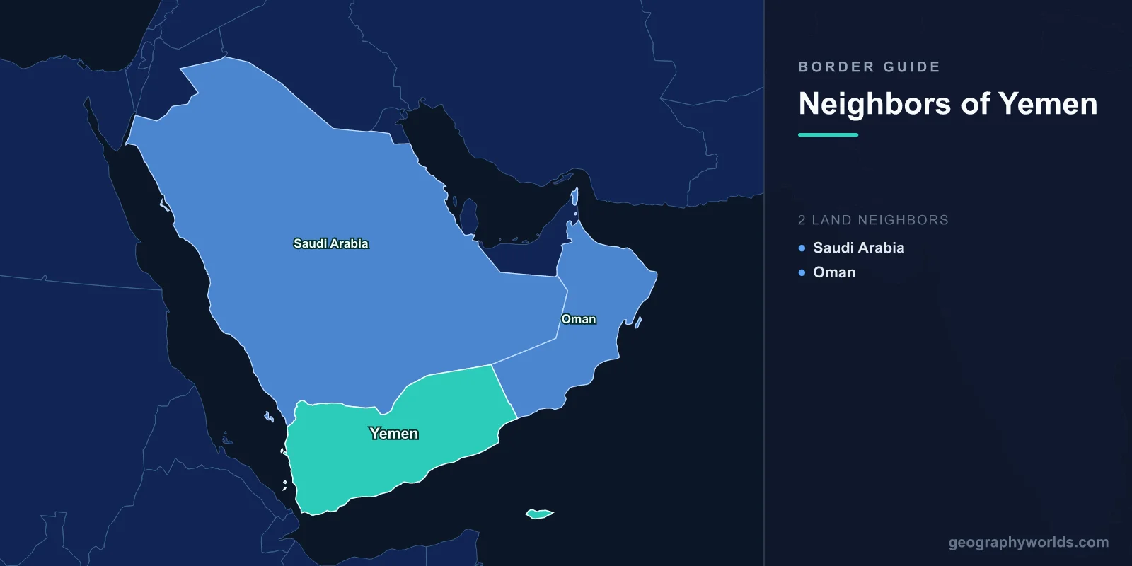
Yemen shares land borders with exactly two countries: Saudi Arabia to the north and Oman to the east. Together they run roughly 1,300 kilometres with Saudi Arabia and close to 300 with Oman, across some of the emptiest terrain on the Arabian Peninsula. Everything else that bounds Yemen is sea — the Red Sea to the west, the Gulf of Aden and the Arabian Sea to the south — and it is the maritime frontier, not the land one, that gives the country its strategic weight.
The Border That Nobody Could Locate
For most of the twentieth century, the Saudi-Yemeni boundary existed in two incompatible versions. The western section, through the mountains of Asir, Jizan and Najran, was settled by force: the Saudi-Yemeni war of 1934 ended with the Treaty of Taif, under which the Zaydi imam of Yemen conceded those three provinces to Ibn Saud. Taif was renewed at intervals but was never accepted by Yemeni nationalists as permanent, and the loss of the three provinces remained a live grievance.
The eastern section simply had no agreed line at all. Beyond the mountains the boundary ran out into the Rub al Khali, the Empty Quarter, where no administration reached and no survey had been attempted. Maps of the region through the 1960s and 1970s show the frontier as a dotted line trailing off into blank desert, sometimes labelled as undefined.
This was tolerable while the sand was worthless. It stopped being tolerable when oil exploration moved toward it, and it produced repeated clashes between tribal forces and border patrols.
The Jeddah Treaty of 2000
The matter was settled by the Treaty of Jeddah, signed in June 2000 after years of negotiation. It confirmed the Taif line in the west and, for the first time, fixed a defined boundary across the desert to the east, running to the tripoint with Oman.
The agreement was unusual in the Gulf for actually being implemented. A joint commission surveyed and demarcated the line, pillars were planted, and the two states exchanged the maps. It also included provisions for cross-border grazing, allowing tribes on both sides to move their herds across the line for several kilometres in each direction — a recognition that a boundary drawn through pastoral territory cannot simply cut a community's seasonal range in half.
Yemen's formal acceptance of the loss of Asir, Jizan and Najran remains politically sensitive, and Houthi rhetoric has periodically reopened the question of the three provinces.
The Wall and the Berm
Within a few years of settling the boundary, Saudi Arabia began physically closing it. From 2003 a security barrier was constructed along sections of the frontier — concrete-filled pipeline in some stretches, sand berms and electronic sensors elsewhere — to stop smuggling and infiltration.
Yemen objected that parts of the structure violated the Jeddah provisions on the border zone, and construction was paused before resuming in modified form. Since 2015 the frontier has been a war zone: the Saudi-led intervention against the Houthi movement turned Jizan, Najran and Asir into the target of cross-border shelling and drone attacks, and Saudi forces have operated inside northern Yemen.
The border also carries one of the world's most dangerous migration routes. Ethiopian and other East African migrants cross the Gulf of Aden to Yemen and attempt to reach Saudi Arabia on foot through the mountains; human rights investigators have documented large numbers of deaths along the crossing.
The Omani Frontier, and Why It Is the Quiet One
Yemen's border with Oman is the opposite case: shorter, later, and almost entirely untroubled. It was agreed in 1992 and demarcated over the following years without significant dispute, running from the Saudi tripoint south-east to the coast of the Arabian Sea near Hawf.
The reason it is easy is partly geography — it crosses sparsely populated desert and the eastern edge of the Dhofar mountains — and partly history. Oman had an interest in a settled frontier after the Dhofar rebellion of the 1960s and 1970s, in which insurgents operated from what was then the Marxist People's Democratic Republic of Yemen. Once that regime ended with Yemeni unification in 1990, the two states had every reason to fix the line quickly.
Since 2015 the Omani crossing at Sarfayt has been one of very few functioning exits from Yemen, used by traders, patients seeking treatment and travellers who cannot fly. Oman's neutrality in the conflict — it is the only Gulf state that did not join the coalition — turned its border into the country's back door and Muscat into the venue for talks between the warring parties.
Socotra, and the Borders That Are Not Land
Yemen's territory extends well beyond its mainland. Socotra, some 350 kilometres off the Horn of Africa and far closer to Somalia than to Yemen, is a UNESCO World Heritage site whose isolation produced flora found nowhere else, including the dragon's blood tree. It has been under the control of the Southern Transitional Council and its Emirati backers for much of the recent conflict.
The Hanish Islands in the Red Sea produced Yemen's only serious modern territorial dispute with an African state. Eritrea seized Greater Hanish by force in 1995; the two governments agreed to arbitration, and the tribunal awarded the main islands to Yemen in 1998 while confirming Eritrean rights in the surrounding waters and traditional fishing regimes for both. Both sides accepted the ruling, which makes it one of the more successful territorial arbitrations of the period.
Who Actually Controls the Crossings
A border is only as meaningful as the authority standing at it, and Yemen has not had one authority since 2014. The northern highlands including Sanaa are administered by the Houthi movement; Aden and much of the south by the internationally recognised government and the Southern Transitional Council; Marib and parts of the east by government-aligned forces; and stretches of Hadhramaut and Mahra by local authorities with Saudi or Emirati backing.
This means the Saudi frontier faces Houthi-held territory along most of its length, while the Omani frontier at Sarfayt faces Mahra, a governorate that has stayed largely out of the fighting and has resisted the stationing of foreign forces on its soil. The practical result is that goods, money and people move through Mahra in volumes the province's population would never generate on its own.
Fuel, food and consumer goods travel the long road from Oman west across the country, and the checkpoints along it are revenue sources for whoever holds them. Control of a road in Yemen is control of a customs regime.
Counting the Kilometres
Yemen's land frontier totals roughly 1,600 kilometres, which is short for a country of its size and population. The Saudi section accounts for around four-fifths of it, curving from the Red Sea coast north of Midi, up through the Jizan and Asir highlands, then east along the edge of the Empty Quarter to the Omani tripoint. The Omani section is under 300 kilometres and runs almost entirely through desert and the eastern fringe of the Dhofar uplands.
Set against that is a coastline of roughly 1,900 kilometres — longer than all the land borders combined. Yemen faces the Red Sea on one side, the Gulf of Aden and the Arabian Sea on the other, and controls the eastern shore of one of the world's most important shipping lanes. It is, in the most literal sense, a maritime state with a short back door.
That ratio explains a great deal of Yemeni history. Ports rather than frontier towns were the country's points of contact with the outside world: Mocha exported the coffee that carries its name, Aden was one of the busiest bunkering ports on earth under British rule, and Mukalla traded across the Indian Ocean to East Africa, India and South East Asia. The Hadhrami diaspora that resulted still has substantial communities in Indonesia, Malaysia, Singapore and the Gulf.
Bab el-Mandeb: The Frontier That Matters Most
The strait separating Yemen from Djibouti and Eritrea is about 30 kilometres wide at its narrowest, and roughly a tenth of world seaborne trade has historically passed through it, including a large share of Europe's oil and almost everything moving between Asia and the Suez Canal.
That is why a country with two land neighbours and no oil wealth to speak of attracts sustained international attention. Attacks on shipping launched from Yemeni territory since 2023 have rerouted a substantial part of Asia-Europe container traffic around the Cape of Good Hope, adding thousands of kilometres and a week or more to voyages, and cutting Suez Canal revenues sharply.
Perim Island, sitting in the middle of the strait and Yemeni territory, has been fortified and contested repeatedly for exactly this reason. Britain garrisoned it from 1857 precisely to control the passage.
The Internal Line That Behaves Like a Border
Yemen also contains a de facto frontier that appears on no map of international boundaries. The Yemen Arab Republic in the north and the People's Democratic Republic of Yemen in the south were separate states until unification in 1990, and their old boundary ran east from Bab el-Mandeb across the country.
A southern secession attempt in 1994 was defeated militarily, but southern grievance did not disappear, and since 2017 the Southern Transitional Council has controlled Aden and much of the former PDRY territory. Front lines in the current war have at points approximated the pre-1990 line, and any settlement of the conflict will have to decide whether that line becomes a border again.
What the Two Borders Mean Now
For a country of more than 40 million people facing one of the world's largest humanitarian emergencies, the practical consequence of having two land neighbours is stark. When ports are blockaded or damaged and the airport's operations are restricted, overland routes are what remain — and one of the two is a closed military frontier.
The terrain these frontiers cross is described in our Yemen country guide, and our Middle East countries guide sets them beside the region's others.
