

Decolonization was the most comprehensive geographic transformation of the 20th century. Between 1945 and 1975, over 80 new nations gained independence from European colonial empires, primarily in Africa, Asia, the Middle East, and the Pacific. The world map went from being dominated by a handful of imperial colors to a kaleidoscope of independent nations.
Introduction
The geographic consequences of decolonization were profound but paradoxical. While political independence was achieved, the geographic framework of colonialism, the borders, infrastructure, economic structures, and administrative systems, was largely inherited intact. New nations were born into colonial geographic bodies, creating tensions between political sovereignty and geographic dependency that persist to this day.
Geographic Context
- Pre-WWII Colonies: ~85% of Earth's surface had been colonized
- New Nations (1945-75): 80+
- Colonial Powers: Britain, France, Netherlands, Portugal, Belgium, Spain
- Key Regions: Africa, South/Southeast Asia, Middle East, Pacific
By 1945, European colonial empires controlled roughly 85% of the Earth's land surface. The British Empire alone governed one-quarter of the planet. France controlled a vast African empire plus Indochina. The Netherlands held the East Indies (Indonesia). Portugal clung to Angola, Mozambique, and other territories. Belgium controlled the Congo.
World War II fatally weakened the colonial powers. Britain and France were economically exhausted. Japan's wartime conquests had shattered the myth of European invincibility in Asia. The United States and Soviet Union, the new superpowers, both opposed colonialism (for different reasons). The geographic framework for decolonization was set.
Key Events
- India/Pakistan Independence: 1947
- African Year: 1960 (17 nations independent)
- Portuguese Colonial Wars: 1961-1975
- Last Major Colony: Hong Kong returned to China, 1997
India's independence in 1947 was the geographic tipping point. The loss of the "jewel in the crown" demonstrated that even the world's largest empire could not resist the tide of decolonization. India's geographic transformation, with Partition creating India, Pakistan, and eventually Bangladesh, set the template for the messy geographic realities of post-colonial statehood.
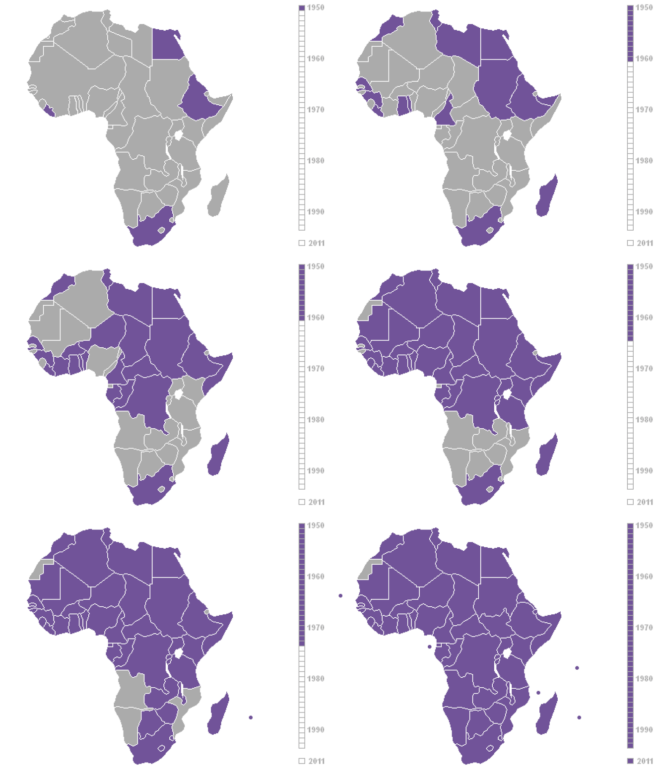
1960, "The Year of Africa," saw 17 nations gain independence, primarily from France. The speed was dizzying: in a single year, territories covering millions of square kilometers and tens of millions of people became sovereign states. Many had little economic infrastructure, few trained administrators, and borders that divided ethnic groups and combined incompatible populations.
Territorial Changes
- Africa: 54 nations from ~50 colonial territories
- Asia: ~25 new nations
- Middle East: ~15 new nations from Ottoman/colonial territories
- Pacific: ~15 new island nations
Africa's decolonization was the most geographically dramatic, transforming the entire continent from a patchwork of colonial territories into 54 independent nations within roughly two decades. The borders of these new states almost universally followed colonial administrative boundaries, regardless of ethnic, linguistic, or geographic logic.
In Asia, decolonization created geographic giants: India (3.3 million km²), Indonesia (1.9 million km², the world's largest archipelagic state), and Pakistan. It also created geographic anomalies: East Pakistan was separated from West Pakistan by 1,600 km of Indian territory. Singapore, expelled from Malaysia in 1965, became one of the world's smallest independent states.
Lasting Impact
- Inherited Borders: Colonial borders retained by almost all new nations
- Economic Dependency: Colonial economic structures persisted
- Language Legacy: Colonial languages became official in most new states
The decision to retain colonial borders, enshrined in the OAU's 1964 Cairo Declaration for Africa, was pragmatic but consequential. It prevented border wars but locked in the geographic arbitrariness of colonial cartography. Ethnic groups remained divided, incompatible populations remained yoked together, and the geographic framework of colonial administration became the permanent architecture of independent states.
Colonial economic geography proved even more durable than political colonialism. Railways still run from mines to ports, not between African capitals. Cash-crop agriculture still displaces food production. Former colonies still export raw materials to former colonial powers. This geographic economic orientation, designed for extraction rather than development, has proven extraordinarily resistant to change.
Modern Relevance
- Developing World: Post-colonial nations still face geographic challenges
- Ongoing Dependencies: Economic, military, linguistic ties to former colonizers
- Border Disputes: Colonial-era borders continue to generate conflict
Decolonization's geographic legacy is the developing world itself. The nations categorized as "developing" are overwhelmingly former colonies whose economic geography was shaped by colonial exploitation rather than domestic development. The geographic infrastructure of colonialism, from port cities built for export to national borders that fracture ethnic homelands, remains the operating system of the post-colonial world.
Understanding decolonization is essential for understanding 21st-century geography. From the civil wars in the Congo and South Sudan (both products of colonial borders) to the ethnic tensions in Myanmar and Sri Lanka (legacies of colonial divide-and-rule) to the economic challenges of island nations in the Pacific (where colonial trade patterns persist), the geographic consequences of colonialism and decolonization continue to shape the lives of billions.
Key Facts
- Over 80 new nations gained independence between 1945 and 1975.
- By 1945, European colonial empires controlled roughly 85% of the Earth's land surface.
- 1960, "The Year of Africa," saw 17 nations gain independence in a single year.
- Almost all post-colonial nations retained their inherited colonial borders.
- Colonial economic infrastructure (railways from mines to ports) persists in most former colonies.
Fun Facts
- Indonesia's independence created the world's largest archipelagic state: over 17,000 islands spanning 5,000 km from east to west, a geographic entity that had never existed as a unified state before Dutch colonization.
- When the Congo gained independence from Belgium in 1960, it had fewer than 30 university graduates in a country of 15 million people, illustrating how colonialism had developed geographic infrastructure while neglecting human development.
- Timor-Leste (East Timor) did not achieve full independence until 2002, making it one of the newest nations on Earth, because it was a Portuguese colony colonized a second time by Indonesia in 1975.
- The Maldives, a chain of 1,192 coral islands with an average elevation of just 1.5 meters, faces the existential geographic threat of disappearing entirely due to sea level rise, a post-colonial nation potentially un-made by geography.
Final Thoughts
Decolonization was the most sweeping geographic transformation of the modern era, creating over 80 new nations and remaking the world map within three decades. Yet the geographic legacy of colonialism, its borders, infrastructure, economic patterns, and institutional frameworks, persists within every post-colonial state. Understanding decolonization means understanding how the geography of power can outlast the power itself.
Test Your Knowledge!
Think you know your historical geography? Try our interactive geography quiz!
Play Country Quiz →