

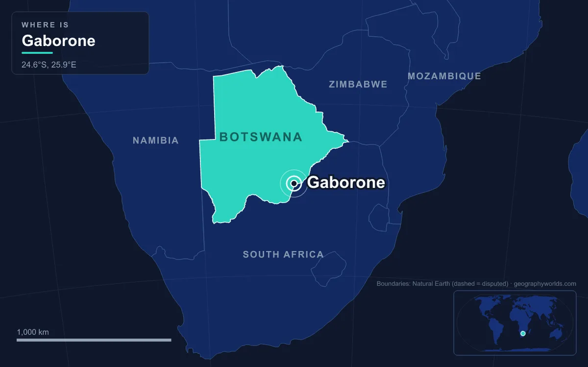
Gaborone is the capital and largest city of Botswana, set in the country’s south-eastern corner between Kgale Hill and Oodi Hill on the Notwane River, only about 15 kilometres from the South African border. The 2022 census counted 246,325 people in the city itself, about a tenth of the national population, and 534,842 across the wider metropolitan area. What sets Gaborone apart from almost every other African capital is its age: the modern city was laid out on nearly empty ground from 1964 onwards, so that a country about to become independent would have a seat of government inside its own borders for the first time.
Moshaweng and Gaberones, 1880–1963
People had lived along the Notwane for centuries before any town appeared. Around 1880 the Tlokwa, led by Chief Gaborone, moved north from the Magaliesberg ranges in what is now South Africa and settled beside the river at a place they called Moshaweng. The chief’s name is usually translated as “it does not fit badly” or “it is not unbecoming”, and European settlers turned “Gaborone’s village” into Gaberones. His home village, today’s Tlokweng, lay on the far bank of the river from the small colonial post known as the Government Camp. That camp is the source of the city’s modern nickname, GC.
In 1890 Cecil Rhodes picked Gaberones as the site for a colonial fort, but for the next seventy years the place stayed small. The oddity of the period was where the colony was actually run from. The Bechuanaland Protectorate, proclaimed by Britain on 31 March 1885, was administered from Mafeking, a town that lay outside the protectorate altogether, south of the Molopo River in British Bechuanaland and later South Africa. For almost its entire existence, and from 1894 at the latest, the protectorate was governed from a town beyond its own border, and that arrangement could not survive independence.
Choosing a Capital Site, 1963–1965
When self-government came into view in the early 1960s, the obvious candidate was Lobatse, an existing town on the railway further south. Planners judged it too cramped for a capital, and the choice fell instead on open land next to the old Gaberones. Four arguments carried the decision. The site had a reliable source of fresh water; it lay on the railway line to Pretoria; it was central to the main Tswana groups of the south-east; and, just as important, it belonged to none of them, so no single chiefdom could claim the new capital as its own.
Water came first. Construction of the Gaborone Dam on the Notwane began in 1963, while the city was still on the drawing board, and the earth-fill wall was finished in 1964. The reservoir filled and overflowed during the 1965–66 rainy season, just as the first residents arrived. In 1965 the administration of the protectorate finally moved from Mafeking to Gaberones, the same year Botswana became self-governing.

Building the Brandy Glass, 1964–1966
Work on the town started in mid-1964 and followed garden city principles, with footpaths separated from roads and generous open spaces. Geoffrey Cornish, chairman of the Gaberones Township Authority, compared the plan to a brandy glass. Government offices sat in the rounded base, and a long commercial strip, the Main Mall, formed the stem. That shape is still readable on a map of the centre: the semicircular Government Enclave, home to the National Assembly and the Ntlo ya Dikgosi (the advisory house of chiefs), with the Mall running away from it towards the Civic Centre.
Most of the early town went up in about three years. The builders delivered assembly buildings, ministries, a power station, a hospital, schools, a radio station, a telephone exchange, police stations, a post office and more than 1,000 houses, all sized for a town of about 20,000 people. On 30 September 1966 Bechuanaland became the Republic of Botswana, the eleventh British dependency in Africa to gain independence, with Gaberones as its capital. The Reverend Derek Jones became the first mayor, the colonial settlement was absorbed as a suburb still called “the Village”, and in 1969 the city dropped the colonial spelling and became Gaborone.

Naledi and the Housing Squeeze, 1966–1975
Building so fast created a problem the plan had not allowed for. Thousands of labourers came to put up the capital, and there was nowhere official for them to live. They built their own homes on land set aside for industry in the south of the city, and the settlement became known as Naledi, “the star”, a name that can also mean “under the open sky”. The authorities tried several fixes. In 1971 the Town Council and the Ministry of Local Government and Lands surveyed Bontleng for low-cost housing. In 1973 the Botswana Housing Corporation built a “New Naledi” across the road from the old one and moved residents there, but many disliked the new houses and the old settlement kept growing. The question was settled in 1975, when President Sir Seretse Khama rezoned Naledi from an industrial zone into a low-income residential area, accepting the city its residents had built.
The numbers explain the pressure. Gaborone had 3,855 residents in 1964 and almost 18,000 seven years later. The National Museum and Art Gallery opened in 1968, a sign that the new town was starting to act like a national capital rather than a construction camp.
Raids Across the Border, 1980–1994
A capital 15 kilometres from apartheid South Africa could not stay out of the region’s conflicts. Botswana followed a policy of non-alignment, yet South African exiles, including members of the African National Congress, lived in and around Gaborone. In the early hours of 14 June 1985, about 50 South African Defence Force soldiers crossed near the Tlokweng border post and attacked homes and offices in Tlokweng, Broadhurst and elsewhere in the city. Pretoria called the operation “Plecksy”. Twelve people were killed, including women and children, and only five of the dead were ANC members. Among the dead was the South African graphic artist Thamsanqa Mnyele, who had been living in exile in the city.
The same decade brought a very different kind of regional role. In April 1980 nine majority-ruled states created the Southern African Development Coordination Conference to reduce their economic dependence on South Africa, and Gaborone became its home. When the body was reorganised as the Southern African Development Community (SADC) under the Windhoek Treaty of 17 August 1992, the headquarters stayed in Gaborone, where it now serves 16 member states. Growth did not slow: by 1992 the city had about 138,000 people, nearly seven times the population it was designed for. After the 1994 general election, riots broke out in the capital over high unemployment, a reminder that jobs had not kept pace with arrivals.
Diamonds, Drought and the Dikgosi, 1995–2022
Botswana’s diamond wealth runs through Gaborone even though the mines lie far from the capital. Debswana, the joint venture between De Beers and the government, has its headquarters in the city, and its rough stones are sorted and valued at Orapa House, on the corner of Khama Crescent and Nelson Mandela Drive, a building designed to let in steady indirect light for grading. The Bank of Botswana, the Botswana Stock Exchange and Air Botswana are based here too, along with a Diamond Technology Park built to keep more cutting and polishing in the country.
Water, the reason the site was chosen, became its weak point. The dam had already been raised by 7 metres between 1983 and 1985, to a height of 25 metres and a length of 3.6 kilometres, giving it a capacity of about 141 million cubic metres. Even so, lower rainfall, high evaporation and a thirstier city drained it. The reservoir was 79 per cent full at the end of 2002, 27 per cent at the end of 2004 and 17 per cent by September 2005, forcing strict water restrictions. Part of the city’s supply is now piped from the Letsibogo Dam far to the north, one reason Gaborone’s water tariffs are among the highest in the country.
The city also began to build its own national symbols. On 29 September 2005, the eve of Independence Day, President Festus Mogae unveiled the Three Dikgosi Monument in the Central Business District. Its bronze figures, each 5.4 metres tall, show Khama III, Sebele I and Bathoen I, the chiefs who travelled to Britain in 1895 and persuaded the government not to hand the protectorate to Cecil Rhodes’s British South Africa Company. The statues were made by the North Korean firm Mansudae Overseas Projects, a commission that angered local sculptors, and critics also noted that the monument leaves out other founding figures such as Sechele I.
A Capital of 246,325 in the 2022 Census
The 2022 census recorded 118,727 men and 127,598 women in 58,476 households. Growth of about 3.4 per cent a year has been the highest in Botswana, and almost half of the country’s citizens now live within 100 kilometres of the capital. Much of that growth lands outside the city boundary, in commuter towns such as Tlokweng, Mogoditshane and Ramotswa, or in affluent Phakalane about 13 kilometres north of the centre. The railway that helped decide the site still cuts the city north to south; passenger trains stopped on 1 April 2009 and returned in 2016.
For many readers abroad the city is still the Gaborone of Alexander McCall Smith’s No. 1 Ladies’ Detective Agency novels, whose detective, Precious Ramotswe, solves her cases in and around the capital. The real city is sunnier and drier than most capitals, with a hot semi-arid climate, rain falling mostly between October and April, and more than 3,300 hours of sunshine a year. It sits on the eastern fringe of the Kalahari, which covers much of the country, and its whole urban history fits inside a single lifetime. For the wider national picture, from the Okavango to the salt pans, see our Botswana country guide, or compare it with a neighbouring capital whose water story is just as central in our piece on Windhoek, Namibia’s highland capital.
Quick Facts About Gaborone
- Country: Botswana
- Continent: Africa (Southern Africa)
- Country population: approximately 2.6 million
- Capital city status: Gaborone is the capital of Botswana, the seat of national government, and the location of foreign embassies, parliament, and the head of state's official residence.
Frequently Asked Questions
What is the capital of Botswana?
The capital of Botswana is Gaborone. Gaborone is the seat of national government, hosts most foreign embassies and consulates, and is typically where the head of state and parliament are located.
What continent is Gaborone in?
Gaborone, the capital of Botswana, is located in Africa, in the Southern Africa region. As Botswana's capital, Gaborone serves as the country's primary connection to the broader African political, economic, and cultural sphere.
Why is Gaborone the capital of Botswana?
Gaborone was chosen as the capital of Botswana for reasons that typically combine geography, history, and politics. Capital city selections often reflect a desire for centrality (being accessible from across the country), historical importance (being a longstanding seat of government or culture), or neutrality (being acceptable to multiple regions or ethnic groups within the country). The specific reasons for Gaborone's designation are detailed in the city's history above.
What is Gaborone known for?
As the capital of Botswana, Gaborone is best known for housing the country's central government institutions — parliament, presidential or royal residences, supreme court, and key ministries. It is also typically a major cultural and economic center within Botswana, hosting national museums, embassies, and signature monuments. The introduction and history sections above provide detailed coverage of the city's specific notable institutions and landmarks.
Related Pages
- Botswana Country Guide — full geography, climate, economy, and culture overview
- Flag of Botswana — meaning, history, and design of Botswana's national flag